List of species
-
Mallomonas
-
a
- Mallomonas acaroides
- Mallomonas acaroides var. inermis
- Mallomonas actinoloma
- Mallomonas actinoloma var. maramuresensis
- Mallomonas actinoloma var. nadiensis
- Mallomonas adamas
- Mallomonas akrokomos
- Mallomonas alata
- Mallomonas allorgei
- Mallomonas alphaphora
- Mallomonas alpina
- Mallomonas alveolata
- Mallomonas annulata
- Mallomonas areolata
-
b - c
- Mallomonas balonovii
- Mallomonas bangladeshica
- Mallomonas calceolus
- Mallomonas canina
- Mallomonas caudata
- Mallomonas clavus
- Mallomonas conspersa
- Mallomonas corcontica
- Mallomonas corymbosa
- Mallomonas costata
- Mallomonas crassisquama
- Mallomonas crassisquama var. papillosa
- Mallomonas cratis
- Mallomonas cristata
- Mallomonas cucullata
- Mallomonas cyathellata
- d - g
- h - k
-
l - m
- Mallomonas labyrinthina
- Mallomonas leboimei
- Mallomonas lelymene
- Mallomonas lychenensis
- Mallomonas lychenensis f. symposiaca
- Mallomonas maculata
- Mallomonas mangofera
- Mallomonas mangofera var. gracilis
- Mallomonas mangofera var. reticulata
- Mallomonas matvienkoae
- Mallomonas multisetigera
- Mallomonas multiunca
- Mallomonas munda
- o - ph
-
pi - pu
- Mallomonas pillula
- Mallomonas pillula f. exannulata
- Mallomonas pillula f. latimarginalis
- Mallomonas pillula f. valdiviana
- Mallomonas portae-ferreae
- Mallomonas prora
- Mallomonas pseudocoronata
- Mallomonas pseudocratis
- Mallomonas pugio
- Mallomonas pumilio
- Mallomonas pumilio var. dispersa
- Mallomonas punctifera
- Mallomonas punctifera var. brasiliensis
- r - s
- t - z
-
a
-
Synura
- a - g
- h - m
- n - u
- Neotessella
-
Paraphysomonas
- a - ci
- co - h
- i - q
- r - v
-
Lepidochromonas
- c - i
-
m - u
- Lepidochromonas manubriata
- Lepidochromonas morchella
- Lepidochromonas poteriophora
- Lepidochromonas quadrispina
- Lepidochromonas runcinifera
- Lepidochromonas sigillifera
- Lepidochromonas stelligera
- Lepidochromonas stephanolepis
- Lepidochromonas subquadrangularis
- Lepidochromonas subrotacea
- Lepidochromonas takahashii
- Lepidochromonas undulata
-
Spiniferomonas
- a - c
- m - t
- Chrysosphaerella
- Polylepidomonas
Search
General information
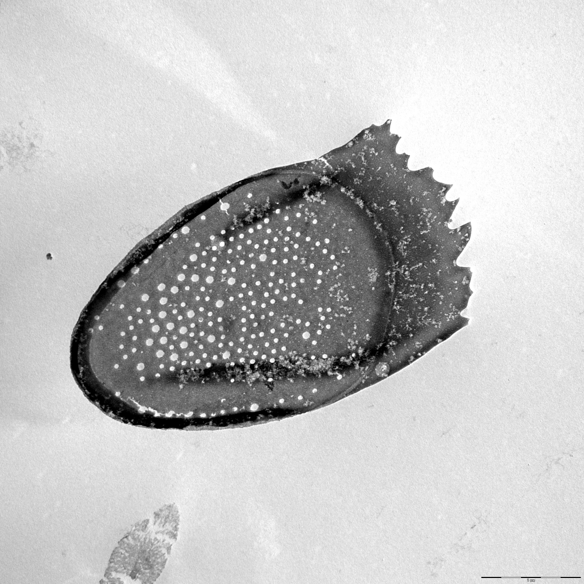
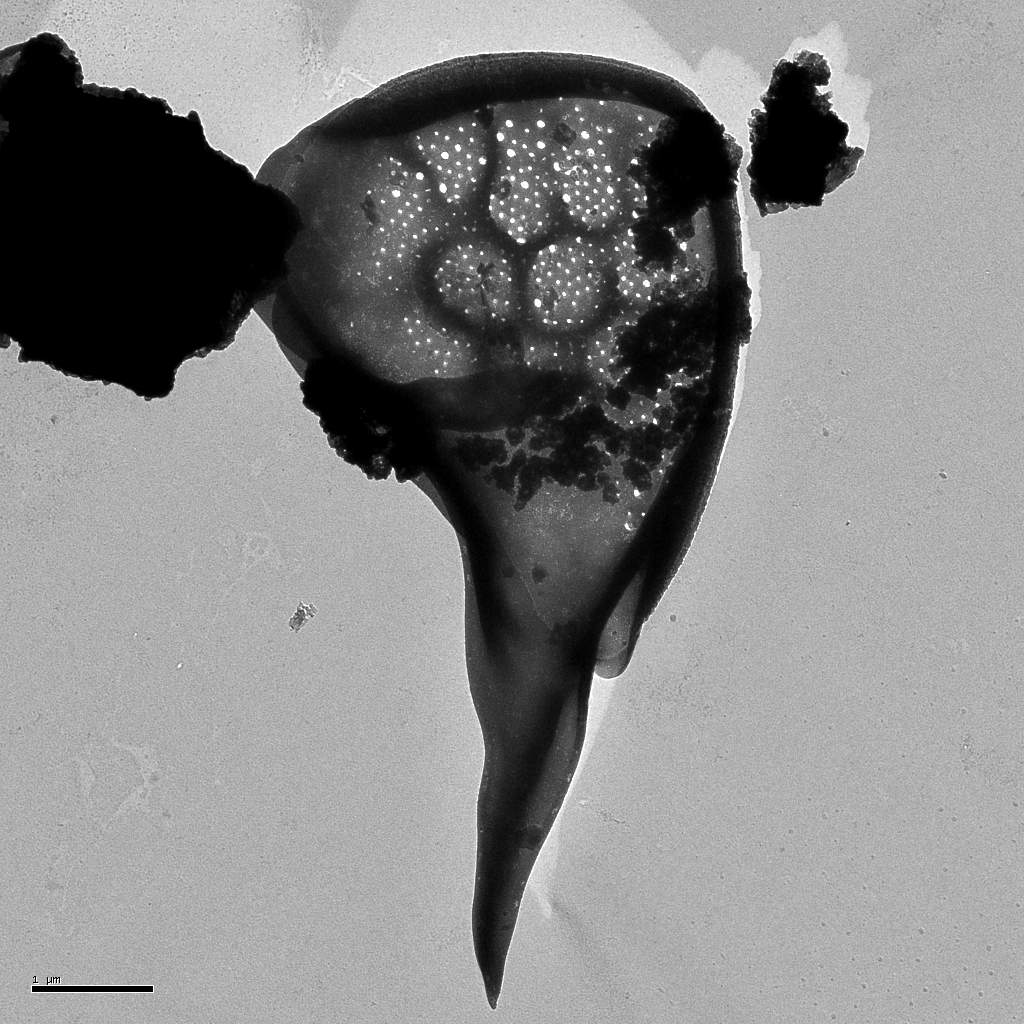
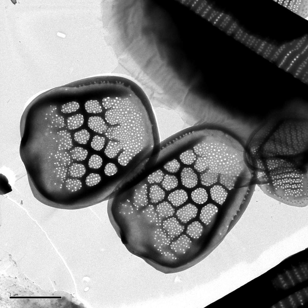
Description: Korshikov, A.A. (1941). On some new or little known flagellates. Archiv für Protistenkunde 95: 22-44.
Autecology: alkaliphilic to pH indifferent.
Distribution: Northern temperate, incl. arctic.
Image gallery

List of records
| Locality | Sampling date | pH | Conductivity (μS/cm) | Temperature (°C) | Coordinates | References |
|---|---|---|---|---|---|---|
| Lygnern lake | 2021 | 6.4 | 85 | 15.5 | 57.5348617, 12.4288819 | SKALOUD et al. (2025) |
| Spalena Borkovna | 2021 | 6.6 | 126 | 48.9800389, 14.7994933 | SKALOUD et al. (2025) | |
| Vltavský luh | 2002 | 5.3 | 63 | 48.82893, 13.937779 | SEJNOHOVA (2003) | |
| cutoff of the river Labe | 2014 | 7.4 | 307 | 20.0 | 50.361841, 15.910475 | CERTNEROVA (unpublished) |
| Gieringer Weiher | 2012 | 7.6 | 102 | 11.9 | 47.4707, 12.3626 | PICHRTOVÁ et al. (2013) |
| Bufernoe lake, Vorkutinskaya tundra, Russia | 2002 | 6.8 | 9.0 | 67.519926, 64.35585 | VOLOSHKO (2012) | |
| Bousquet region, wetland near Lac du Bourg | 2010 | 7.2 | 224 | 25.5 | 44.498517, -0.638753 | NEMCOVA et al. (2012) |
| Bousquet region, wetland near Lac du Bourg | 2010 | 6.9 | 224 | 25.8 | 44.498583, -0.639417 | NEMCOVA et al. (2012) |
| Bousquet region, a reed encircled small pool | 2010 | 4.7 | 79 | 44.499889, -0.643 | NEMCOVA et al. (2012) | |
| Schönwalder Allee, pond | 52.584017, 13.164439 | GUTOWSKI (1997) |
Distribution map
Lygnern lake
Locality:
Lygnern lake
Coordinates:
57.5348617, 12.4288819
Spalena Borkovna
Locality:
Spalena Borkovna
Coordinates:
48.9800389, 14.7994933
Vltavský luh
Locality:
Vltavský luh
Coordinates:
48.82893, 13.937779
cutoff of the river Labe
Locality:
cutoff of the river Labe
Coordinates:
50.361841, 15.910475
Gieringer Weiher
Locality:
Gieringer Weiher
Coordinates:
47.4707, 12.3626
Bufernoe lake, Vorkutinskaya tundra, Russia
Locality:
Bufernoe lake, Vorkutinskaya tundra, Russia
Coordinates:
67.519926, 64.35585
Bousquet region, wetland near Lac du Bourg
Locality:
Bousquet region, wetland near Lac du Bourg
Coordinates:
44.498517, -0.638753
Bousquet region, wetland near Lac du Bourg
Locality:
Bousquet region, wetland near Lac du Bourg
Coordinates:
44.498583, -0.639417
Bousquet region, a reed encircled small pool
Locality:
Bousquet region, a reed encircled small pool
Coordinates:
44.499889, -0.643
Schönwalder Allee, pond
Locality:
Schönwalder Allee, pond
Coordinates:
52.584017, 13.164439
Rückertteich
Locality:
Rückertteich
Coordinates:
52.461265, 13.305427
brackish water of Pojo Bay
Locality:
brackish water of Pojo Bay
Coordinates:
60.041875, 23.493462
Trummen
Locality:
Trummen
Coordinates:
56.862041, 14.831793
Sammakkolampi
Locality:
Sammakkolampi
Coordinates:
63.237995, 24.690692
Ladozskoye ozero, lake
Locality:
Ladozskoye ozero, lake
Coordinates:
60.802064, 31.513367
Konnevesi
Locality:
Konnevesi
Coordinates:
62.600846, 26.547575
Vendyurskoye ozero, Karelia
Locality:
Vendyurskoye ozero, Karelia
Coordinates:
62.217876, 33.253155
Ukshozero, Karelia
Locality:
Ukshozero, Karelia
Coordinates:
61.971557, 34.1609
Syamozero, Karelia
Locality:
Syamozero, Karelia
Coordinates:
61.962844, 33.083839
Lizhmozero, Karelia
Locality:
Lizhmozero, Karelia
Coordinates:
62.623036, 34.068489
Urosozero, Karelia
Locality:
Urosozero, Karelia
Coordinates:
63.440993, 34.253883
Konchezero, Karelia
Locality:
Konchezero, Karelia
Coordinates:
62.138238, 33.978538
Pertozero, Karelia
Locality:
Pertozero, Karelia
Coordinates:
64.458587, 34.00177
Rind-Ozero, lake, Karelia
Locality:
Rind-Ozero, lake, Karelia
Coordinates:
62.251283, 33.24681
lake Trummen
Locality:
lake Trummen
Coordinates:
56.862018, 14.829819
Mathislesweiher
Locality:
Mathislesweiher
Coordinates:
47.884953, 8.084214
Moorweiher in Bärnau
Locality:
Moorweiher in Bärnau
Coordinates:
49.81085, 12.433949
Eixendorfer Speicher
Locality:
Eixendorfer Speicher
Coordinates:
49.339441, 12.445965
Kainzmühlspeicher
Locality:
Kainzmühlspeicher
Coordinates:
49.574657, 12.297907
Volgogradskoye Vodokhranilishche, reservoir
Locality:
Volgogradskoye Vodokhranilishche, reservoir
Coordinates:
51.429183, 46.027908
Saratovskoye Vodokhranilishche, reservoir
Locality:
Saratovskoye Vodokhranilishche, reservoir
Coordinates:
53.449522, 49.609623
Kuybyshevskoye Vodokhranilishche, reservoir
Locality:
Kuybyshevskoye Vodokhranilishche, reservoir
Coordinates:
53.460255, 49.103394
Gor'kovskoye Vodokhranilishche, reservoir
Locality:
Gor'kovskoye Vodokhranilishche, reservoir
Coordinates:
57.212916, 43.096619
Sheksinskoye Vodokhranilishche, reservoir
Locality:
Sheksinskoye Vodokhranilishche, reservoir
Coordinates:
59.730206, 38.542142
Rybinskoye Vodokhranilishche, reservoir
Locality:
Rybinskoye Vodokhranilishche, reservoir
Coordinates:
58.450607, 38.2901
Kis-Jusztus swamp, temporary
Locality:
Kis-Jusztus swamp, temporary
Coordinates:
47.57502, 21.022854
Kisköre reservoir, before Tisza bridge
Locality:
Kisköre reservoir, before Tisza bridge
Coordinates:
47.653363, 20.685883
Rókás, backwater of the Danube
Locality:
Rókás, backwater of the Danube
Coordinates:
47.094319, 18.922648
Estoto Lake
Locality:
Estoto Lake
Coordinates:
67.316667, 65.55
small lake near Estoto Lake
Locality:
small lake near Estoto Lake
Coordinates:
67.283333, 65.733333
alluvial pools, Lužnice River, Mallomonas in years 2000-2003
Locality:
alluvial pools, Lužnice River, Mallomonas in years 2000-2003
Coordinates:
48.810255, 14.930763
Ribeiro do Pano, small tributary of Pateira de Fermentelos
Locality:
Ribeiro do Pano, small tributary of Pateira de Fermentelos
Coordinates:
40.574375, -8.53608
Poço do grifo, large ditch
Locality:
Poço do grifo, large ditch
Coordinates:
40.630679, -8.559118
Brejo de Segadães, ditch
Locality:
Brejo de Segadães, ditch
Coordinates:
40.605922, -8.491234
Portela, reservoir of river Mondego
Locality:
Portela, reservoir of river Mondego
Coordinates:
40.185037, -8.394785
Acude de Coimbra, eservoir of river Mondego
Locality:
Acude de Coimbra, eservoir of river Mondego
Coordinates:
40.21657, -8.441463
Barragem da Raiva, reservoir of river Mondego
Locality:
Barragem da Raiva, reservoir of river Mondego
Coordinates:
40.318017, -8.23102
river Coa at Sabugal
Locality:
river Coa at Sabugal
Coordinates:
40.351319, -7.09641
Laukunlampi - sediment core
Locality:
Laukunlampi - sediment core
Coordinates:
62.667878, 29.15607
undefined localities (approx. coord.)
Locality:
undefined localities (approx. coord.)
Coordinates:
61.543641, 25.422363
Växjösjön - eutrophic polluted lake
Locality:
Växjösjön - eutrophic polluted lake
Coordinates:
56.867554, 14.809198
Trummen - eutrophic-polluted lake
Locality:
Trummen - eutrophic-polluted lake
Coordinates:
56.851225, 14.781218
Adams göl
Locality:
Adams göl
Coordinates:
57.162917, 14.561162
Straken - oligotrophic humic lake
Locality:
Straken - oligotrophic humic lake
Coordinates:
57.09523, 14.59631
Allgunnen - oligotrophic clear water lake
Locality:
Allgunnen - oligotrophic clear water lake
Coordinates:
57.210685, 14.599228
sediment core, lake Lilla Öresjön
Locality:
sediment core, lake Lilla Öresjön
Coordinates:
57.551968, 12.326353
sediment core, lake Verevatn
Locality:
sediment core, lake Verevatn
Coordinates:
58.69817, 8.156605
sediment core, lake Röyrtjörna
Locality:
sediment core, lake Röyrtjörna
Coordinates:
64.668863, 12.178974
lake Haukilampi
Locality:
lake Haukilampi
Coordinates:
61.719166, 26.841974
Malvaniemi, lake Puulavesi
Locality:
Malvaniemi, lake Puulavesi
Coordinates:
61.729005, 26.817598
Pääskynniemi II, shore of lake Puulavesi
Locality:
Pääskynniemi II, shore of lake Puulavesi
Coordinates:
61.722337, 26.897936
Pääskynniemi I, shore of lake Puulavesi
Locality:
Pääskynniemi I, shore of lake Puulavesi
Coordinates:
61.703546, 26.907377
Merrasmäki, pond at the lake Kotkatvesi
Locality:
Merrasmäki, pond at the lake Kotkatvesi
Coordinates:
61.669615, 26.871135
Sawmill, lake Kotkatvesi
Locality:
Sawmill, lake Kotkatvesi
Coordinates:
61.672934, 26.849699
Rehniöniemi, lake Ryökäsvesi
Locality:
Rehniöniemi, lake Ryökäsvesi
Coordinates:
61.627042, 26.845922
12 lakes in Seitseminen National Park
Locality:
12 lakes in Seitseminen National Park
Coordinates:
61.930228, 23.412437
13 lakes in Salamajärvi National Park
Locality:
13 lakes in Salamajärvi National Park
Coordinates:
63.290007, 24.693432
9 lakes in Isojärvi National Park
Locality:
9 lakes in Isojärvi National Park
Coordinates:
61.701756, 25.003452
8 lakes in Pyhä-Häkki National Park
Locality:
8 lakes in Pyhä-Häkki National Park
Coordinates:
62.848253, 25.467625
Etuniemi - beach beside Lake Liekune
Locality:
Etuniemi - beach beside Lake Liekune
Coordinates:
61.669839, 26.744442
Geuldert, Helbeek , pH 5.9-7.3
Locality:
Geuldert, Helbeek , pH 5.9-7.3
Coordinates:
51.737651, 5.929827
Sonröda träsk, Åland
Locality:
Sonröda träsk, Åland
Coordinates:
60.272515, 20.129514
Brantsböle Träsk, Åland
Locality:
Brantsböle Träsk, Åland
Coordinates:
60.26911, 19.925201
Zeller Loch, Fulda
Locality:
Zeller Loch, Fulda
Coordinates:
50.513392, 9.620998
Geuldert
Locality:
Geuldert
Coordinates:
51.737651, 5.929827
Erpewaai III
Locality:
Erpewaai III
Coordinates:
51.761054, 5.827293
Erpewaai III
Locality:
Erpewaai III
Coordinates:
51.761054, 5.827293
Erpewaai II
Locality:
Erpewaai II
Coordinates:
51.761054, 5.827293
Erpewaai II
Locality:
Erpewaai II
Coordinates:
51.761054, 5.827293
Oisterwijkse Vennen, group of moorland pools, Staalbergsven
Locality:
Oisterwijkse Vennen, group of moorland pools, Staalbergsven
Coordinates:
51.57301, 5.222797
Haarsteegse Wiel: harbour
Locality:
Haarsteegse Wiel: harbour
Coordinates:
51.718946, 5.18383
Broekse Wielen IV., pond near the river Meuse
Locality:
Broekse Wielen IV., pond near the river Meuse
Coordinates:
51.728889, 5.763788
Broekse Wielen II., pond near the river Meuse
Locality:
Broekse Wielen II., pond near the river Meuse
Coordinates:
51.728889, 5.763788
Broekse Wielen I., pond near the river Meuse
Locality:
Broekse Wielen I., pond near the river Meuse
Coordinates:
51.728889, 5.763788
moorland pool, near Rolvennen I.
Locality:
moorland pool, near Rolvennen I.
Coordinates:
51.171244, 6.107883
small pond at playgrounds in Nijmegen
Locality:
small pond at playgrounds in Nijmegen
Coordinates:
51.831322, 5.812454
pond D of the Oude Waal, pH neutral to slightly alkaline
Locality:
pond D of the Oude Waal, pH neutral to slightly alkaline
Coordinates:
51.853091, 5.896783
Szeremlei holtág, a sluice on backwater of the R. Danube at Baja city
Locality:
Szeremlei holtág, a sluice on backwater of the R. Danube at Baja city
Coordinates:
46.168874, 18.941966
Baláta-tó, bog lake complex, shallow waters among sedge humocks and floating peat islands, after ice melting
Locality:
Baláta-tó, bog lake complex, shallow waters among sedge humocks and floating peat islands, after ice melting
Coordinates:
46.311011, 17.207508
Hortobágy, small fishpond
Locality:
Hortobágy, small fishpond
Coordinates:
47.609404, 21.065254
Hortobágy, large fishpond
Locality:
Hortobágy, large fishpond
Coordinates:
47.609404, 21.065254
Killarney, Loch Beg
Locality:
Killarney, Loch Beg
Coordinates:
51.972401, -9.609729
Vash.-Kharbey, small pond
Locality:
Vash.-Kharbey, small pond
Coordinates:
67.896867, 61.745544
Vashutkini, Vaniukti Lake
Locality:
Vashutkini, Vaniukti Lake
Coordinates:
67.960497, 61.519275
Vashutkini, Vaniukti Lake
Locality:
Vashutkini, Vaniukti Lake
Coordinates:
67.963789, 61.51905
Province of Limburg, Geuldert
Locality:
Province of Limburg, Geuldert
Coordinates:
51.737651, 5.929827
Province of Gelderland, Erpewaai IV
Locality:
Province of Gelderland, Erpewaai IV
Coordinates:
51.761054, 5.827293
Lake Ladoga, Estuary of Burnaya River, station 61
Locality:
Lake Ladoga, Estuary of Burnaya River, station 61
Coordinates:
60.613933, 30.594177
Lake Ladoga, Volchov Bay, station 1
Locality:
Lake Ladoga, Volchov Bay, station 1
Coordinates:
60.177038, 32.321777
Lake Ladoga, Petrokrepost Bay, station A
Locality:
Lake Ladoga, Petrokrepost Bay, station A
Coordinates:
60.168842, 31.080322
Magleås Conference Centre, Høsterkøb, North Zealand
Locality:
Magleås Conference Centre, Høsterkøb, North Zealand
Coordinates:
55.855363, 12.468255
Madriz marsh
Locality:
Madriz marsh
Coordinates:
40.179431, -8.688576
Madriz puddle
Locality:
Madriz puddle
Coordinates:
40.179431, -8.688576
Prokopova pool
Locality:
Prokopova pool
Coordinates:
48.833894, 14.927651
T2 pool
Locality:
T2 pool
Coordinates:
48.835123, 14.927174
T2 pool
Locality:
T2 pool
Coordinates:
48.835123, 14.927174
T2 pool
Locality:
T2 pool
Coordinates:
48.835123, 14.927174
T2 pool
Locality:
T2 pool
Coordinates:
48.835123, 14.927174
T2 pool
Locality:
T2 pool
Coordinates:
48.835123, 14.927174
T2 pool
Locality:
T2 pool
Coordinates:
48.835123, 14.927174
T2 pool
Locality:
T2 pool
Coordinates:
48.835123, 14.927174
T2 pool
Locality:
T2 pool
Coordinates:
48.835123, 14.927174
pond in Zizkuv Dvorec
Locality:
pond in Zizkuv Dvorec
Coordinates:
48.892381, 14.607171
Sabrava brook
Locality:
Sabrava brook
Coordinates:
49.556966, 15.915574
Velke Darko pond
Locality:
Velke Darko pond
Coordinates: