List of species
-
Mallomonas
-
a
- Mallomonas acaroides
- Mallomonas acaroides var. inermis
- Mallomonas actinoloma
- Mallomonas actinoloma var. maramuresensis
- Mallomonas actinoloma var. nadiensis
- Mallomonas adamas
- Mallomonas akrokomos
- Mallomonas alata
- Mallomonas allorgei
- Mallomonas alphaphora
- Mallomonas alpina
- Mallomonas alveolata
- Mallomonas annulata
- Mallomonas areolata
-
b - c
- Mallomonas balonovii
- Mallomonas bangladeshica
- Mallomonas calceolus
- Mallomonas canina
- Mallomonas caudata
- Mallomonas clavus
- Mallomonas conspersa
- Mallomonas corcontica
- Mallomonas corymbosa
- Mallomonas costata
- Mallomonas crassisquama
- Mallomonas crassisquama var. papillosa
- Mallomonas cratis
- Mallomonas cristata
- Mallomonas cucullata
- Mallomonas cyathellata
- d - g
- h - k
-
l - m
- Mallomonas labyrinthina
- Mallomonas leboimei
- Mallomonas lelymene
- Mallomonas lychenensis
- Mallomonas lychenensis f. symposiaca
- Mallomonas maculata
- Mallomonas mangofera
- Mallomonas mangofera var. gracilis
- Mallomonas mangofera var. reticulata
- Mallomonas matvienkoae
- Mallomonas multisetigera
- Mallomonas multiunca
- Mallomonas munda
- o - ph
-
pi - pu
- Mallomonas pillula
- Mallomonas pillula f. exannulata
- Mallomonas pillula f. latimarginalis
- Mallomonas pillula f. valdiviana
- Mallomonas portae-ferreae
- Mallomonas prora
- Mallomonas pseudocoronata
- Mallomonas pseudocratis
- Mallomonas pugio
- Mallomonas pumilio
- Mallomonas pumilio var. dispersa
- Mallomonas punctifera
- Mallomonas punctifera var. brasiliensis
- r - s
- t - z
-
a
-
Synura
- a - g
- h - m
- n - u
- Neotessella
-
Paraphysomonas
- a - ci
- co - h
- i - q
- r - v
-
Lepidochromonas
- c - i
-
m - u
- Lepidochromonas manubriata
- Lepidochromonas morchella
- Lepidochromonas poteriophora
- Lepidochromonas quadrispina
- Lepidochromonas runcinifera
- Lepidochromonas sigillifera
- Lepidochromonas stelligera
- Lepidochromonas stephanolepis
- Lepidochromonas subquadrangularis
- Lepidochromonas subrotacea
- Lepidochromonas takahashii
- Lepidochromonas undulata
-
Spiniferomonas
- a - c
- m - t
- Chrysosphaerella
- Polylepidomonas
Search
General information
Description: Lucas, I.A.N. (1967): Two marine species of Paraphysomonas. - J. mar. biol. Ass. U.K. 47: 329-334.
Autecology: acidophilic to pH indifferent, temperature tolerant.
Distribution: cosmopolitan, widely distributed.
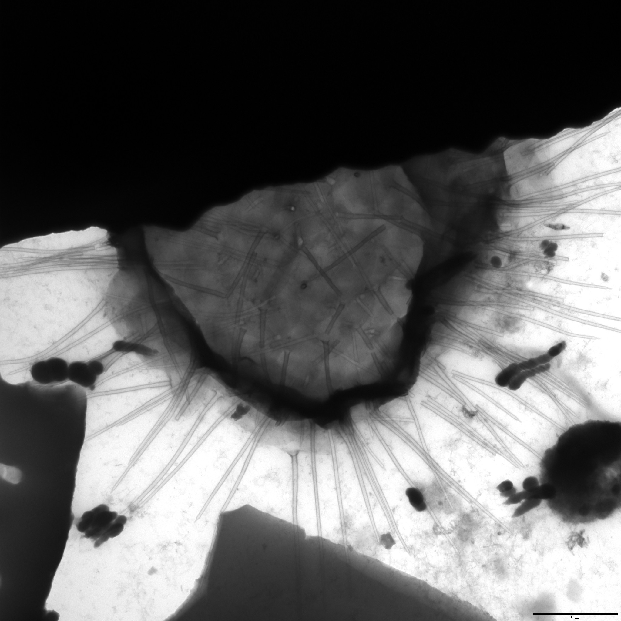
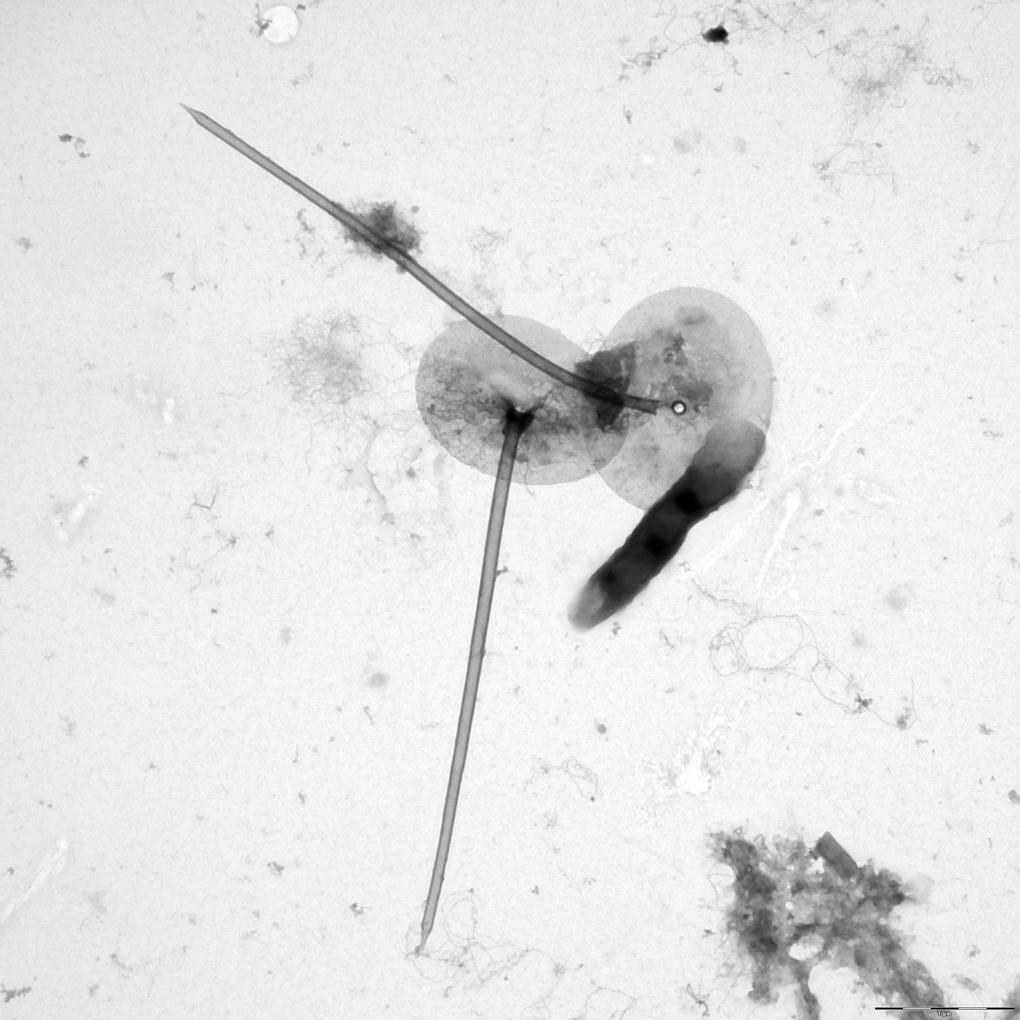
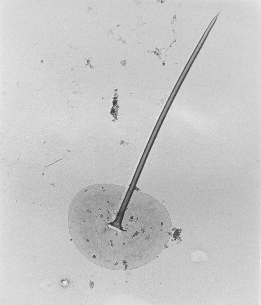
Image gallery
List of records
| Locality | Sampling date | pH | Conductivity (μS/cm) | Temperature (°C) | Coordinates | References |
|---|---|---|---|---|---|---|
| Five lakes in Kab-hegyi | 2013 | 47, 17.6 | PADISÁK et al. (2015) | |||
| Piburger See | 2012 | 7.5 | 71 | 8.3 | 47.1952, 10.8861 | PICHRTOVÁ et al. (2013) |
| Möserer See | 2012 | 8.2 | 371 | 5.8 | 47.3144, 11.1442 | PICHRTOVÁ et al. (2013) |
| Herzsee | 2012 | 8.2 | 312 | 12.8 | 47.248533, 11.455436 | PICHRTOVÁ et al. (2013) |
| Schwarzsee | 2012 | 7.7 | 247 | 9.5 | 47.456155, 12.366958 | PICHRTOVÁ et al. (2013) |
| Gieringer Weiher | 2012 | 7.6 | 102 | 11.9 | 47.4707, 12.3626 | PICHRTOVÁ et al. (2013) |
| Längsee | 2012 | 8.4 | 253 | 11.2 | 47.600492, 12.154999 | PICHRTOVÁ et al. (2013) |
| brackish water of Pojo Bay | 1990 | 60.041875, 23.493462 | IKÄVALKO (1994b) | |||
| HANSEN et al. (1993b) | ||||||
| HANSEN et al. (1993b) |
Distribution map
Five lakes in Kab-hegyi
Locality:
Five lakes in Kab-hegyi
Coordinates:
47, 17.6
Piburger See
Locality:
Piburger See
Coordinates:
47.1952, 10.8861
Möserer See
Locality:
Möserer See
Coordinates:
47.3144, 11.1442
Herzsee
Locality:
Herzsee
Coordinates:
47.248533, 11.455436
Schwarzsee
Locality:
Schwarzsee
Coordinates:
47.456155, 12.366958
Gieringer Weiher
Locality:
Gieringer Weiher
Coordinates:
47.4707, 12.3626
Längsee
Locality:
Längsee
Coordinates:
47.600492, 12.154999
brackish water of Pojo Bay
Locality:
brackish water of Pojo Bay
Coordinates:
60.041875, 23.493462
Konnevesi
Locality:
Konnevesi
Coordinates:
62.600846, 26.547575
Lebrader Teich
Locality:
Lebrader Teich
Coordinates:
54.220536, 10.428421
Grosser Binnensee
Locality:
Grosser Binnensee
Coordinates:
54.325434, 10.622821
Garrensee
Locality:
Garrensee
Coordinates:
53.687813, 10.850193
Oberer Ausgrabensee
Locality:
Oberer Ausgrabensee
Coordinates:
54.177432, 10.446446
Unterer Ausgrabensee
Locality:
Unterer Ausgrabensee
Coordinates:
54.17497, 10.437562
Neversdorfer See
Locality:
Neversdorfer See
Coordinates:
53.867839, 10.265601
Heidensee
Locality:
Heidensee
Coordinates:
54.139563, 10.473139
Plusssee inlet, west
Locality:
Plusssee inlet, west
Coordinates:
54.182267, 10.440969
Plusssee
Locality:
Plusssee
Coordinates:
54.182003, 10.443957
Schöhsee
Locality:
Schöhsee
Coordinates:
54.165273, 10.439622
Suhrer See
Locality:
Suhrer See
Coordinates:
54.150799, 10.473354
Kleiner Kolksee
Locality:
Kleiner Kolksee
Coordinates:
54.155901, 10.716126
Tresdorfer See
Locality:
Tresdorfer See
Coordinates:
54.233029, 10.467088
Nikolassee
Locality:
Nikolassee
Coordinates:
52.424146, 13.192077
lake Trummen
Locality:
lake Trummen
Coordinates:
56.862018, 14.829819
Bergsee
Locality:
Bergsee
Coordinates:
47.57143, 7.936406
Baltic sea ice station
Locality:
Baltic sea ice station
Coordinates:
59.972195, 25.394897
Baltic sea ice station
Locality:
Baltic sea ice station
Coordinates:
59.968931, 25.451546
Baltic sea ice station
Locality:
Baltic sea ice station
Coordinates:
62.315175, 20.418091
Baltic sea ice station
Locality:
Baltic sea ice station
Coordinates:
64.261895, 22.404213
Baltic sea ice station
Locality:
Baltic sea ice station
Coordinates:
64.091408, 22.490387
Kis-Jusztus swamp, temporary
Locality:
Kis-Jusztus swamp, temporary
Coordinates:
47.57502, 21.022854
Kis-Balaton reservoir
Locality:
Kis-Balaton reservoir
Coordinates:
46.628221, 17.151604
small pond, 2.5 km south from Sármellék, at the road towards Balatonmagyaród
Locality:
small pond, 2.5 km south from Sármellék, at the road towards Balatonmagyaród
Coordinates:
46.682892, 17.169714
Sós-tó, boating pond
Locality:
Sós-tó, boating pond
Coordinates:
46.93447, 18.13194
Rókás, backwater of the Danube
Locality:
Rókás, backwater of the Danube
Coordinates:
47.094319, 18.922648
small groundwater pond before entering Szigetcsép, at the road coming from Tököl
Locality:
small groundwater pond before entering Szigetcsép, at the road coming from Tököl
Coordinates:
47.272561, 18.975512
Kuzty Lake
Locality:
Kuzty Lake
Coordinates:
67.6, 65.65
Bolshoye Schjuchie Lake
Locality:
Bolshoye Schjuchie Lake
Coordinates:
67.833333, 66.333333
Channel near B. Khadata Lake
Locality:
Channel near B. Khadata Lake
Coordinates:
67.616667, 66.333333
Sidiyambtosio Lake
Locality:
Sidiyambtosio Lake
Coordinates:
68.116667, 65.5
Lake Kavicsos, Budapest
Locality:
Lake Kavicsos, Budapest
Coordinates:
47.387716, 19.057152
Lake Feneketlen, Budapest
Locality:
Lake Feneketlen, Budapest
Coordinates:
47.476622, 19.041685
oligotrophic pool near lake Vassijaure
Locality:
oligotrophic pool near lake Vassijaure
Coordinates:
68.439917, 18.266483
Priest Pot, pond
Locality:
Priest Pot, pond
Coordinates:
54.372134, -2.99052
lake Ozeros and adjacent pond
Locality:
lake Ozeros and adjacent pond
Coordinates:
38.656829, 21.223125
lake Lysimachia
Locality:
lake Lysimachia
Coordinates:
38.56518, 21.369517
lake Pamvotis
Locality:
lake Pamvotis
Coordinates:
39.671785, 20.877056
Ølene
Locality:
Ølene
Coordinates:
55.100987, 15.014012
Kis-Balaton reservoir
Locality:
Kis-Balaton reservoir
Coordinates:
46.635294, 17.146111
undefined localities (approx. coord.)
Locality:
undefined localities (approx. coord.)
Coordinates:
61.543641, 25.422363
Växjösjön - eutrophic polluted lake
Locality:
Växjösjön - eutrophic polluted lake
Coordinates:
56.867554, 14.809198
Kalven - eutrophic - polluted lake
Locality:
Kalven - eutrophic - polluted lake
Coordinates:
57.178366, 14.595752
Adams göl
Locality:
Adams göl
Coordinates:
57.162917, 14.561162
Byggets göl - oligotrophic humic lake
Locality:
Byggets göl - oligotrophic humic lake
Coordinates:
57.10163, 14.584853
Gardsjön - oligotrophic humic lake
Locality:
Gardsjön - oligotrophic humic lake
Coordinates:
57.154306, 14.631672
Skärshultsjön - oligotrophic humic lake
Locality:
Skärshultsjön - oligotrophic humic lake
Coordinates:
57.163429, 14.508018
Helgasjön - oligotrophic clear water lake
Locality:
Helgasjön - oligotrophic clear water lake
Coordinates:
56.962947, 14.728317
Allgunnen - oligotrophic clear water lake
Locality:
Allgunnen - oligotrophic clear water lake
Coordinates:
57.210685, 14.599228
lake Haukilampi
Locality:
lake Haukilampi
Coordinates:
61.719166, 26.841974
Malvaniemi, lake Puulavesi
Locality:
Malvaniemi, lake Puulavesi
Coordinates:
61.729005, 26.817598
Pääskynniemi II, shore of lake Puulavesi
Locality:
Pääskynniemi II, shore of lake Puulavesi
Coordinates:
61.722337, 26.897936
Pääskynniemi I, shore of lake Puulavesi
Locality:
Pääskynniemi I, shore of lake Puulavesi
Coordinates:
61.703546, 26.907377
Merrasmäki, pond at the lake Kotkatvesi
Locality:
Merrasmäki, pond at the lake Kotkatvesi
Coordinates:
61.669615, 26.871135
Sawmill, lake Kotkatvesi
Locality:
Sawmill, lake Kotkatvesi
Coordinates:
61.672934, 26.849699
Rehniöniemi, lake Ryökäsvesi
Locality:
Rehniöniemi, lake Ryökäsvesi
Coordinates:
61.627042, 26.845922
Helvetinjärvi
Locality:
Helvetinjärvi
Coordinates:
62.046, 23.784657
12 lakes in Seitseminen National Park
Locality:
12 lakes in Seitseminen National Park
Coordinates:
61.930228, 23.412437
13 lakes in Salamajärvi National Park
Locality:
13 lakes in Salamajärvi National Park
Coordinates:
63.290007, 24.693432
Geuldert, Helbeek , pH 5.9-7.3
Locality:
Geuldert, Helbeek , pH 5.9-7.3
Coordinates:
51.737651, 5.929827
lake Þingvallavatn and adjacent ponds
Locality:
lake Þingvallavatn and adjacent ponds
Coordinates:
64.197113, -21.137123
Tystrup Sø
Locality:
Tystrup Sø
Coordinates:
55.369356, 11.570606
lake Lysimachia
Locality:
lake Lysimachia
Coordinates:
38.56518, 21.369517
lake Ozeros and adjacent pond
Locality:
lake Ozeros and adjacent pond
Coordinates:
38.656829, 21.223125
lake Pamvotis
Locality:
lake Pamvotis
Coordinates:
39.671785, 20.877056
St. Jansberg
Locality:
St. Jansberg
Coordinates:
51.737813, 5.922781
Geuldert
Locality:
Geuldert
Coordinates:
51.737651, 5.929827
Erpewaai IV
Locality:
Erpewaai IV
Coordinates:
51.761054, 5.827293
Erpewaai III
Locality:
Erpewaai III
Coordinates:
51.761054, 5.827293
ditch near Ooyendonk
Locality:
ditch near Ooyendonk
Coordinates:
51.610342, 5.325108
Loampit near Udenhout, pond
Locality:
Loampit near Udenhout, pond
Coordinates:
51.608903, 5.182114
ditch system near Haarsteegse Wiel, pH 6.3.-7.9
Locality:
ditch system near Haarsteegse Wiel, pH 6.3.-7.9
Coordinates:
51.718946, 5.18383
ditch at Mariaheide
Locality:
ditch at Mariaheide
Coordinates:
51.644442, 5.582428
small pool near Shayk (Shaijk)
Locality:
small pool near Shayk (Shaijk)
Coordinates:
51.741433, 5.632467
Broekse Wielen IV., pond near the river Meuse
Locality:
Broekse Wielen IV., pond near the river Meuse
Coordinates:
51.728889, 5.763788
Broekse Wielen II., pond near the river Meuse
Locality:
Broekse Wielen II., pond near the river Meuse
Coordinates:
51.728889, 5.763788
Broekse Wielen I., pond near the river Meuse
Locality:
Broekse Wielen I., pond near the river Meuse
Coordinates:
51.728889, 5.763788
Bosbeek, a brook about 1 km from its origin
Locality:
Bosbeek, a brook about 1 km from its origin
Coordinates:
51.171244, 6.107883
pool near Dutch-German border
Locality:
pool near Dutch-German border
Coordinates:
51.186445, 6.157666
small ditch in Nijmegen
Locality:
small ditch in Nijmegen
Coordinates:
51.831322, 5.812454
pond F of the Oude Waal, pH neutral to slightly alkaline
Locality:
pond F of the Oude Waal, pH neutral to slightly alkaline
Coordinates:
51.855847, 5.900259
pond D of the Oude Waal, pH neutral to slightly alkaline
Locality:
pond D of the Oude Waal, pH neutral to slightly alkaline
Coordinates:
51.853091, 5.896783
pond D of the Oude Waal, pH neutral to slightly alkaline
Locality:
pond D of the Oude Waal, pH neutral to slightly alkaline
Coordinates:
51.853091, 5.896783
Killarney, Upper Lake
Locality:
Killarney, Upper Lake
Coordinates:
51.974228, -9.604004
Killarney, Lough Leane
Locality:
Killarney, Lough Leane
Coordinates:
52.022617, -9.532338
Vash.-Kharbey, small pond
Locality:
Vash.-Kharbey, small pond
Coordinates:
67.920061, 61.743128
Province of Limburg, Geuldert
Locality:
Province of Limburg, Geuldert
Coordinates:
51.737651, 5.929827
Province of Gelderland, Erpewaai IV
Locality:
Province of Gelderland, Erpewaai IV
Coordinates:
51.761054, 5.827293
Province of Gelderland, Erpewaai II
Locality:
Province of Gelderland, Erpewaai II
Coordinates:
51.761054, 5.827293
Province of Gelderland, Erpewaai I
Locality:
Province of Gelderland, Erpewaai I
Coordinates:
51.761054, 5.827293
Bracos
Locality:
Bracos
Coordinates:
41.175317, -8.329108
Mondego Basin, Raiva
Locality:
Mondego Basin, Raiva
Coordinates:
41.274694, -7.510169
Serra da Esterela Natural Park, Covao do Curral
Locality:
Serra da Esterela Natural Park, Covao do Curral
Coordinates:
40.426303, -7.538896
Lake Ladoga, Svir Bay, station 17
Locality:
Lake Ladoga, Svir Bay, station 17
Coordinates:
60.543775, 32.667847
Lake Ladoga, Petrokrepost Bay, station C
Locality:
Lake Ladoga, Petrokrepost Bay, station C
Coordinates:
60.114145, 31.333008
Madriz puddle
Locality:
Madriz puddle
Coordinates:
40.179431, -8.688576
Quinhendros marsh
Locality:
Quinhendros marsh
Coordinates:
40.128101, -8.635745
Ransky pond
Locality:
Ransky pond
Coordinates:
49.683124, 15.83293
Sabrava brook
Locality:
Sabrava brook
Coordinates:
49.556966, 15.915574
Matejovsky pond
Locality:
Matejovsky pond
Coordinates: