List of species
-
Mallomonas
-
a
- Mallomonas acaroides
- Mallomonas acaroides var. inermis
- Mallomonas actinoloma
- Mallomonas actinoloma var. maramuresensis
- Mallomonas actinoloma var. nadiensis
- Mallomonas adamas
- Mallomonas akrokomos
- Mallomonas alata
- Mallomonas allorgei
- Mallomonas alphaphora
- Mallomonas alpina
- Mallomonas alveolata
- Mallomonas annulata
- Mallomonas areolata
-
b - c
- Mallomonas balonovii
- Mallomonas bangladeshica
- Mallomonas calceolus
- Mallomonas canina
- Mallomonas caudata
- Mallomonas clavus
- Mallomonas conspersa
- Mallomonas corcontica
- Mallomonas corymbosa
- Mallomonas costata
- Mallomonas crassisquama
- Mallomonas crassisquama var. papillosa
- Mallomonas cratis
- Mallomonas cristata
- Mallomonas cucullata
- Mallomonas cyathellata
- d - g
- h - k
-
l - m
- Mallomonas labyrinthina
- Mallomonas leboimei
- Mallomonas lelymene
- Mallomonas lychenensis
- Mallomonas lychenensis f. symposiaca
- Mallomonas maculata
- Mallomonas mangofera
- Mallomonas mangofera var. gracilis
- Mallomonas mangofera var. reticulata
- Mallomonas matvienkoae
- Mallomonas multisetigera
- Mallomonas multiunca
- Mallomonas munda
- o - ph
-
pi - pu
- Mallomonas pillula
- Mallomonas pillula f. exannulata
- Mallomonas pillula f. latimarginalis
- Mallomonas pillula f. valdiviana
- Mallomonas portae-ferreae
- Mallomonas prora
- Mallomonas pseudocoronata
- Mallomonas pseudocratis
- Mallomonas pugio
- Mallomonas pumilio
- Mallomonas pumilio var. dispersa
- Mallomonas punctifera
- Mallomonas punctifera var. brasiliensis
- r - s
- t - z
-
a
-
Synura
- a - g
- h - m
- n - u
- Neotessella
-
Paraphysomonas
- a - ci
- co - h
- i - q
- r - v
-
Lepidochromonas
- c - i
-
m - u
- Lepidochromonas manubriata
- Lepidochromonas morchella
- Lepidochromonas poteriophora
- Lepidochromonas quadrispina
- Lepidochromonas runcinifera
- Lepidochromonas sigillifera
- Lepidochromonas stelligera
- Lepidochromonas stephanolepis
- Lepidochromonas subquadrangularis
- Lepidochromonas subrotacea
- Lepidochromonas takahashii
- Lepidochromonas undulata
-
Spiniferomonas
- a - c
- m - t
- Chrysosphaerella
- Polylepidomonas
Search
General information
Description: Lund, J.W.G. (1942). Contributions to the knowledge of British Chrysophyceae. New Phytologist 41: 274-292.
Autecology: acidophilic to pH indifferent, pollution tolerant.
Distribution: widely distributed, frequent.
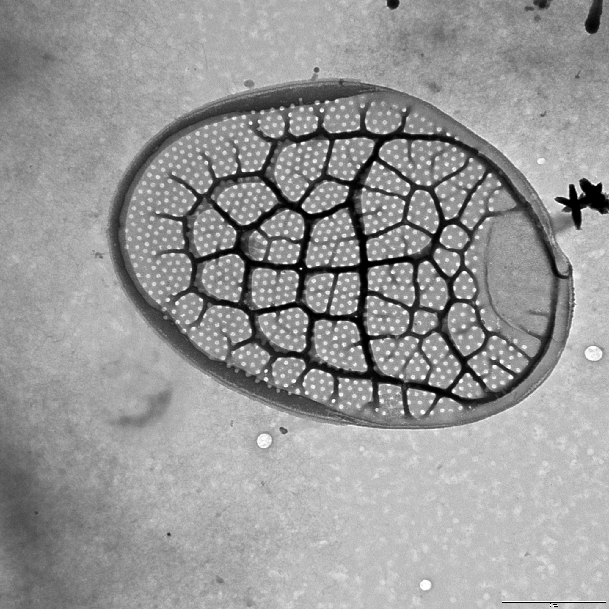
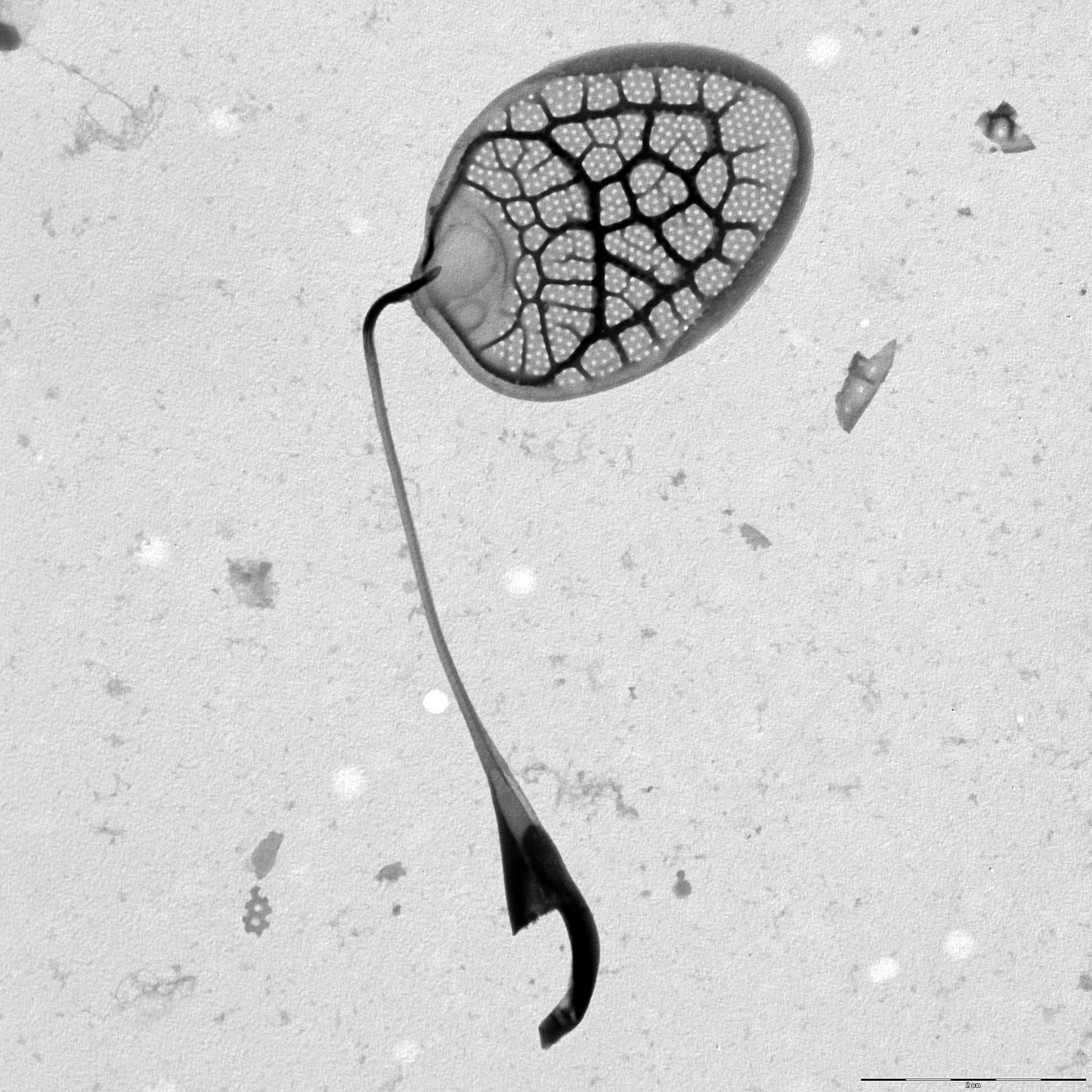
Image gallery


List of records
| Locality | Sampling date | pH | Conductivity (μS/cm) | Temperature (°C) | Coordinates | References |
|---|---|---|---|---|---|---|
| Five lakes in Kab-hegyi | 2013 | 47, 17.6 | PADISÁK et al. (2015) | |||
| alluvial pool 107 | 2022 | 7.7 | 278 | 4.3 | 48.8391514, 14.9149114 | SKALOUD et al. (2025) |
| Vltavský luh | 2002 | 5.3 | 63 | 48.82893, 13.937779 | SEJNOHOVA (2003) | |
| ephemeral pool | 2016 | 58.064468, 38.243574 | KAPUSTIN (unpublished) | |||
| pond Ahijarv | 2013 | 7.3 | 196 | 18.0 | 58.306502, 27.182326 | CERTNEROVA & SKALOUD (2020) |
| Emajoe-Suursoo sookaitseala/maastikukaitseala | 2013 | 6.7 | 157 | 21.0 | 58.335374, 27.263844 | CERTNEROVA & SKALOUD (2020) |
| Lake Suur Linajarv | 2013 | 7.4 | 340 | 15.0 | 58.876229, 26.2743 | CERTNEROVA & SKALOUD (2020) |
| Kropfsee | 2012 | 8.5 | 354 | 14.6 | 47.273, 10.8034 | PICHRTOVÁ et al. (2013) |
| fishpond near Mauschlhütte | 2012 | 47.275415, 10.808101 | PICHRTOVÁ et al. (2013) | |||
| Walchsee | 2012 | 8.3 | 343 | 9.5 | 47.651, 12.3252 | PICHRTOVÁ et al. (2013) |
Distribution map
Five lakes in Kab-hegyi
Locality:
Five lakes in Kab-hegyi
Coordinates:
47, 17.6
alluvial pool 107
Locality:
alluvial pool 107
Coordinates:
48.8391514, 14.9149114
Vltavský luh
Locality:
Vltavský luh
Coordinates:
48.82893, 13.937779
ephemeral pool
Locality:
ephemeral pool
Coordinates:
58.064468, 38.243574
pond Ahijarv
Locality:
pond Ahijarv
Coordinates:
58.306502, 27.182326
Emajoe-Suursoo sookaitseala/maastikukaitseala
Locality:
Emajoe-Suursoo sookaitseala/maastikukaitseala
Coordinates:
58.335374, 27.263844
Lake Suur Linajarv
Locality:
Lake Suur Linajarv
Coordinates:
58.876229, 26.2743
Kropfsee
Locality:
Kropfsee
Coordinates:
47.273, 10.8034
fishpond near Mauschlhütte
Locality:
fishpond near Mauschlhütte
Coordinates:
47.275415, 10.808101
Walchsee
Locality:
Walchsee
Coordinates:
47.651, 12.3252
Schwarzsee
Locality:
Schwarzsee
Coordinates:
47.456155, 12.366958
Gieringer Weiher
Locality:
Gieringer Weiher
Coordinates:
47.4707, 12.3626
Bufernoe lake, Vorkutinskaya tundra, Russia
Locality:
Bufernoe lake, Vorkutinskaya tundra, Russia
Coordinates:
67.519926, 64.35585
Cazaux-Biscarrosse region, small pool close to Biscarrosse, covered by Salvinia
Locality:
Cazaux-Biscarrosse region, small pool close to Biscarrosse, covered by Salvinia
Coordinates:
44.392444, -1.190667
Cazaux-Biscarrosse region, enclosed bay of Étang de Cazaux
Locality:
Cazaux-Biscarrosse region, enclosed bay of Étang de Cazaux
Coordinates:
44.440928, -1.188319
Rohrpfuhl
Locality:
Rohrpfuhl
Coordinates:
52.597678, 13.161263
Barssee, Berlin
Locality:
Barssee, Berlin
Coordinates:
52.477448, 13.215079
brackish water of Pojo Bay
Locality:
brackish water of Pojo Bay
Coordinates:
60.041875, 23.493462
Federsee
Locality:
Federsee
Coordinates:
48.084214, 9.627028
Trummen
Locality:
Trummen
Coordinates:
56.862675, 14.830334
Pildammen, eutrophic pond in Malmö
Locality:
Pildammen, eutrophic pond in Malmö
Coordinates:
55.589775, 12.995097
Flaten
Locality:
Flaten
Coordinates:
59.250744, 18.154292
Kaunislampi
Locality:
Kaunislampi
Coordinates:
63.242285, 24.905398
Ahvenlampi
Locality:
Ahvenlampi
Coordinates:
63.260711, 24.87535
Pieni Koirajärvi
Locality:
Pieni Koirajärvi
Coordinates:
63.233937, 24.822271
Sysilampi
Locality:
Sysilampi
Coordinates:
63.27793, 24.672883
Valkeisenjärvi
Locality:
Valkeisenjärvi
Coordinates:
63.231095, 24.606578
Kangaslampi
Locality:
Kangaslampi
Coordinates:
63.209729, 24.629445
Konnevesi
Locality:
Konnevesi
Coordinates:
62.600846, 26.547575
Syamozero, Karelia
Locality:
Syamozero, Karelia
Coordinates:
61.962844, 33.083839
Konchezero, Karelia
Locality:
Konchezero, Karelia
Coordinates:
62.138238, 33.978538
Pertozero, Karelia
Locality:
Pertozero, Karelia
Coordinates:
64.458587, 34.00177
meadow pond between Kossau and Schluensee
Locality:
meadow pond between Kossau and Schluensee
Coordinates:
54.197558, 10.46383
meadow pond between Rathjensdorf and Schluensee
Locality:
meadow pond between Rathjensdorf and Schluensee
Coordinates:
54.187024, 10.446619
fishpond in Rixdorf
Locality:
fishpond in Rixdorf
Coordinates:
54.204424, 10.412586
fishpond in Rathjensdorf
Locality:
fishpond in Rathjensdorf
Coordinates:
54.184338, 10.428223
Lebrader Teich
Locality:
Lebrader Teich
Coordinates:
54.220536, 10.428421
Vierer See
Locality:
Vierer See
Coordinates:
54.131265, 10.448842
Heidensee
Locality:
Heidensee
Coordinates:
54.139563, 10.473139
Tresdorfer See
Locality:
Tresdorfer See
Coordinates:
54.233029, 10.467088
Kellersee
Locality:
Kellersee
Coordinates:
54.173589, 10.594153
lake Trummen
Locality:
lake Trummen
Coordinates:
56.862018, 14.829819
Waschsee
Locality:
Waschsee
Coordinates:
47.772301, 11.319115
Schiffhüttensee
Locality:
Schiffhüttensee
Coordinates:
47.773945, 11.317545
strongly eutrophied canal in Schlungenhof
Locality:
strongly eutrophied canal in Schlungenhof
Coordinates:
49.124851, 10.752672
Schluchsee
Locality:
Schluchsee
Coordinates:
47.817535, 8.151112
Windgfällweiher
Locality:
Windgfällweiher
Coordinates:
47.851816, 8.12597
Titisee
Locality:
Titisee
Coordinates:
47.896578, 8.148458
Nonnenmattweiher
Locality:
Nonnenmattweiher
Coordinates:
47.794735, 7.798569
Mathislesweiher
Locality:
Mathislesweiher
Coordinates:
47.884953, 8.084214
Moorweiher in Bärnau
Locality:
Moorweiher in Bärnau
Coordinates:
49.81085, 12.433949
Gaisweiher outflow
Locality:
Gaisweiher outflow
Coordinates:
49.742814, 12.335844
Gaisweiher outflow
Locality:
Gaisweiher outflow
Coordinates:
49.742814, 12.335844
Gaisweiher
Locality:
Gaisweiher
Coordinates:
49.74305, 12.341101
Feisnitzspeicher
Locality:
Feisnitzspeicher
Coordinates:
50.034265, 12.17783
Weissenstädter See
Locality:
Weissenstädter See
Coordinates:
50.101148, 11.878409
Liebensteinspeicher
Locality:
Liebensteinspeicher
Coordinates:
49.809299, 12.336016
Silbersee
Locality:
Silbersee
Coordinates:
49.412481, 12.596984
Eixendorfer Speicher
Locality:
Eixendorfer Speicher
Coordinates:
49.339441, 12.445965
Kainzmühlspeicher
Locality:
Kainzmühlspeicher
Coordinates:
49.574657, 12.297907
Perlsee
Locality:
Perlsee
Coordinates:
49.392849, 12.699208
Gaisweiher
Locality:
Gaisweiher
Coordinates:
49.743896, 12.343998
Rybinskoye Vodokhranilishche, reservoir
Locality:
Rybinskoye Vodokhranilishche, reservoir
Coordinates:
58.450607, 38.2901
mine-lake, Bazsi
Locality:
mine-lake, Bazsi
Coordinates:
46.91769, 17.265186
Kis-Jusztus swamp, temporary
Locality:
Kis-Jusztus swamp, temporary
Coordinates:
47.57502, 21.022854
small groundwater pond before entering Szigetcsép, at the road coming from Tököl
Locality:
small groundwater pond before entering Szigetcsép, at the road coming from Tököl
Coordinates:
47.272561, 18.975512
Hverhóll, Skíðadalur
Locality:
Hverhóll, Skíðadalur
Coordinates:
65.783455, -18.900011
small oligotrophic lake at Abisko
Locality:
small oligotrophic lake at Abisko
Coordinates:
68.347048, 18.911247
Bolshoye Schjuchie Lake
Locality:
Bolshoye Schjuchie Lake
Coordinates:
67.833333, 66.333333
Bolshoye Schjuchie Lake
Locality:
Bolshoye Schjuchie Lake
Coordinates:
67.833333, 66.333333
Channel near B. Khadata Lake
Locality:
Channel near B. Khadata Lake
Coordinates:
67.616667, 66.333333
Ochety Lake st. 2, Basin of Kara River
Locality:
Ochety Lake st. 2, Basin of Kara River
Coordinates:
68.103889, 65.844444
alluvial pools, Lužnice River
Locality:
alluvial pools, Lužnice River
Coordinates:
48.835123, 14.927174
alluvial pools, Lužnice River, Mallomonas in years 2000-2003
Locality:
alluvial pools, Lužnice River, Mallomonas in years 2000-2003
Coordinates:
48.810255, 14.930763
Égeres, small temporary forest pond, Pilis/Visegrád Mountains, Király-valley (approx.)
Locality:
Égeres, small temporary forest pond, Pilis/Visegrád Mountains, Király-valley (approx.)
Coordinates:
47.74, 18.92
Ribeiro do Pano, small tributary of Pateira de Fermentelos
Locality:
Ribeiro do Pano, small tributary of Pateira de Fermentelos
Coordinates:
40.574375, -8.53608
Poço do grifo, large ditch
Locality:
Poço do grifo, large ditch
Coordinates:
40.630679, -8.559118
Store Grydesø
Locality:
Store Grydesø
Coordinates:
55.083821, 15.096495
Kleif
Locality:
Kleif
Coordinates:
66, -19.983333
various localities within 30 miles from Edinburgh, Scotland
Locality:
various localities within 30 miles from Edinburgh, Scotland
Coordinates:
55.953237, -3.188782
Bøgeholm Sø
Locality:
Bøgeholm Sø
Coordinates:
56.062812, 12.532003
Sortesø
Locality:
Sortesø
Coordinates:
56.047308, 12.5559
Bondedam
Locality:
Bondedam
Coordinates:
56.061638, 12.54869
Kobberdam
Locality:
Kobberdam
Coordinates:
56.058715, 12.557788
János Pond, Visegrád mountains
Locality:
János Pond, Visegrád mountains
Coordinates:
47.71364, 19.01981
small pond in mountain grassland, Visegrád mountains
Locality:
small pond in mountain grassland, Visegrád mountains
Coordinates:
47.72682, 19.01658
small bog pond in the Visegrád mountains
Locality:
small bog pond in the Visegrád mountains
Coordinates:
47.713521, 19.040333
small bog pond in the middle of an alder forest, Visegrád mountains
Locality:
small bog pond in the middle of an alder forest, Visegrád mountains
Coordinates:
47.707497, 19.040247
undefined localities (approx. coord.)
Locality:
undefined localities (approx. coord.)
Coordinates:
61.543641, 25.422363
Hestehavedam
Locality:
Hestehavedam
Coordinates:
55.241466, 14.790577
Södra Bergundasjön
Locality:
Södra Bergundasjön
Coordinates:
56.850192, 14.782519
Växjösjön - eutrophic polluted lake
Locality:
Växjösjön - eutrophic polluted lake
Coordinates:
56.867554, 14.809198
Trummen - eutrophic-polluted lake
Locality:
Trummen - eutrophic-polluted lake
Coordinates:
56.851225, 14.781218
Adams göl
Locality:
Adams göl
Coordinates:
57.162917, 14.561162
Lammen - oligotrophic humic lake
Locality:
Lammen - oligotrophic humic lake
Coordinates:
57.164546, 14.602346
Langen - oligotrophic humic lake
Locality:
Langen - oligotrophic humic lake
Coordinates:
57.150396, 14.657078
Lillesjön - oligotrophic clear water lake
Locality:
Lillesjön - oligotrophic clear water lake
Coordinates:
56.947221, 14.706345
Helgasjön - oligotrophic clear water lake
Locality:
Helgasjön - oligotrophic clear water lake
Coordinates:
56.962947, 14.728317
Allgunnen - oligotrophic clear water lake
Locality:
Allgunnen - oligotrophic clear water lake
Coordinates:
57.210685, 14.599228
Fiolen - oligotrophic clear water lake
Locality:
Fiolen - oligotrophic clear water lake
Coordinates:
57.084038, 14.526443
lake Haukilampi
Locality:
lake Haukilampi
Coordinates:
61.719166, 26.841974
Malvaniemi, lake Puulavesi
Locality:
Malvaniemi, lake Puulavesi
Coordinates:
61.729005, 26.817598
Pääskynniemi II, shore of lake Puulavesi
Locality:
Pääskynniemi II, shore of lake Puulavesi
Coordinates:
61.722337, 26.897936
Pääskynniemi I, shore of lake Puulavesi
Locality:
Pääskynniemi I, shore of lake Puulavesi
Coordinates:
61.703546, 26.907377
Merrasmäki, pond at the lake Kotkatvesi
Locality:
Merrasmäki, pond at the lake Kotkatvesi
Coordinates:
61.669615, 26.871135
Sawmill, lake Kotkatvesi
Locality:
Sawmill, lake Kotkatvesi
Coordinates:
61.672934, 26.849699
Rehniöniemi, lake Ryökäsvesi
Locality:
Rehniöniemi, lake Ryökäsvesi
Coordinates:
61.627042, 26.845922
Etuniemi - beach beside Lake Liekune
Locality:
Etuniemi - beach beside Lake Liekune
Coordinates:
61.669839, 26.744442
Geuldert, Helbeek , pH 5.9-7.3
Locality:
Geuldert, Helbeek , pH 5.9-7.3
Coordinates:
51.737651, 5.929827
Tystrup Sø
Locality:
Tystrup Sø
Coordinates:
55.369356, 11.570606
Sonröda träsk, Åland
Locality:
Sonröda träsk, Åland
Coordinates:
60.272515, 20.129514
small forest pond at biological station Husö, Åland, probably temporary
Locality:
small forest pond at biological station Husö, Åland, probably temporary
Coordinates:
60.278866, 19.83034
Brantsböle Träsk, Åland
Locality:
Brantsböle Träsk, Åland
Coordinates:
60.26911, 19.925201
St. Jansberg
Locality:
St. Jansberg
Coordinates:
51.737813, 5.922781
Geuldert
Locality:
Geuldert
Coordinates:
51.737651, 5.929827
Oisterwijkse Vennen, group of moorland pools, Staalbergsven
Locality:
Oisterwijkse Vennen, group of moorland pools, Staalbergsven
Coordinates:
51.57301, 5.222797
Loampit near Udenhout, pond
Locality:
Loampit near Udenhout, pond
Coordinates:
51.608903, 5.182114
ditch near Schijndel
Locality:
ditch near Schijndel
Coordinates:
51.620948, 5.433683
drinking pool between Mill and Beers
Locality:
drinking pool between Mill and Beers
Coordinates:
51.691288, 5.78825
Broekse Wielen IV., pond near the river Meuse
Locality:
Broekse Wielen IV., pond near the river Meuse
Coordinates:
51.728889, 5.763788
Broekse Wielen II., pond near the river Meuse
Locality:
Broekse Wielen II., pond near the river Meuse
Coordinates:
51.728889, 5.763788
Broekse Wielen I., pond near the river Meuse
Locality:
Broekse Wielen I., pond near the river Meuse
Coordinates:
51.728889, 5.763788
moorland pool, near Rolvennen I.
Locality:
moorland pool, near Rolvennen I.
Coordinates:
51.171244, 6.107883
moorland pool, Rolvennen I.
Locality:
moorland pool, Rolvennen I.
Coordinates:
51.171244, 6.107883
pool near Dutch-German border
Locality:
pool near Dutch-German border
Coordinates:
51.186445, 6.157666
small ditch in Nijmegen
Locality:
small ditch in Nijmegen
Coordinates:
51.831322, 5.812454
moorland pools Hatertse and Overasseltse Vennen, Talingenven
Locality:
moorland pools Hatertse and Overasseltse Vennen, Talingenven
Coordinates:
51.78425, 5.805845
moorland pools Hatertse and Overasseltse Vennen, Eendenven
Locality:
moorland pools Hatertse and Overasseltse Vennen, Eendenven
Coordinates:
51.78425, 5.805845
Immerlooplas
Locality:
Immerlooplas
Coordinates:
51.955189, 5.91485
Mestecănişul de la Reci, spring and autumn 1996 and 1997
Locality:
Mestecănişul de la Reci, spring and autumn 1996 and 1997
Coordinates:
45.822582, 25.926525
peat bog Tau cu rogoz near Salicea, under ice
Locality:
peat bog Tau cu rogoz near Salicea, under ice
Coordinates:
46.678387, 23.527885
eutrophic bog, Mestecănişul de la Reci
Locality:
eutrophic bog, Mestecănişul de la Reci
Coordinates:
45.822582, 25.926525
eutrophic bog, Mestecănişul de la Reci
Locality:
eutrophic bog, Mestecănişul de la Reci
Coordinates:
45.822582, 25.926525
Baláta-tó, bog lake complex, shallow waters among sedge humocks and floating peat islands, after ice melting
Locality:
Baláta-tó, bog lake complex, shallow waters among sedge humocks and floating peat islands, after ice melting
Coordinates:
46.311011, 17.207508
roadside Caricetum II. (temporary water)
Locality:
roadside Caricetum II. (temporary water)
Coordinates:
47.582605, 21.129155
Brehynsky pond
Locality:
Brehynsky pond
Coordinates:
50.579167, 14.703611
Vorkuta tundra, pond Vorgashor
Locality:
Vorkuta tundra, pond Vorgashor
Coordinates:
67.583333, 63.783333
Vorkuta tundra, pond Sovetsky
Locality:
Vorkuta tundra, pond Sovetsky
Coordinates:
67.516667, 64.366667
Vorkuta tundra, pond Mulda
Locality:
Vorkuta tundra, pond Mulda
Coordinates:
67.383333, 63.75
Vash.-Kharbey, small pond
Locality:
Vash.-Kharbey, small pond
Coordinates:
67.8868, 62.196694
Vash.-Kharbey, small pond
Locality:
Vash.-Kharbey, small pond
Coordinates:
67.920061, 61.743128
Vash.-Kharbey, small pond
Locality:
Vash.-Kharbey, small pond
Coordinates:
67.896867, 61.745544
Kharbey, small pond
Locality:
Kharbey, small pond
Coordinates:
67.538475, 62.745544
Kharbey, small pond
Locality:
Kharbey, small pond
Coordinates:
67.541078, 62.975869
Kharbey, small pond
Locality:
Kharbey, small pond
Coordinates:
67.540614, 62.979672
Vashutkini, small pond
Locality:
Vashutkini, small pond
Coordinates:
67.965017, 61.532622
Vashutkini, small pond
Locality:
Vashutkini, small pond
Coordinates:
67.962981, 61.529667
Vashutkini, Vaniukti Lake
Locality:
Vashutkini, Vaniukti Lake
Coordinates:
67.960497, 61.519275
Province of Limburg, St. Jansberg
Locality:
Province of Limburg, St. Jansberg
Coordinates:
51.737813, 5.922781
Province of Limburg, Geuldert
Locality:
Province of Limburg, Geuldert
Coordinates:
51.737651, 5.929827
Province of Gelderland, Erpewaai III
Locality:
Province of Gelderland, Erpewaai III
Coordinates:
51.761054, 5.827293
Lake Ladoga, Svir Bay, station 17
Locality:
Lake Ladoga, Svir Bay, station 17
Coordinates:
60.543775, 32.667847
Magleås Conference Centre, Høsterkøb, North Zealand
Locality:
Magleås Conference Centre, Høsterkøb, North Zealand
Coordinates:
55.855363, 12.468255
Madriz marsh
Locality:
Madriz marsh
Coordinates:
40.179431, -8.688576
Madriz puddle
Locality:
Madriz puddle
Coordinates:
40.179431, -8.688576
Madriz puddle
Locality:
Madriz puddle
Coordinates:
40.179431, -8.688576
Madriz puddle
Locality:
Madriz puddle
Coordinates:
40.179431, -8.688576
Quinhendros marsh
Locality:
Quinhendros marsh
Coordinates:
40.128101, -8.635745
Prokopova pool
Locality:
Prokopova pool
Coordinates:
48.833894, 14.927651
Prokopova pool
Locality:
Prokopova pool
Coordinates:
48.833894, 14.927651
T2 pool
Locality:
T2 pool
Coordinates:
48.835123, 14.927174
T2 pool
Locality:
T2 pool
Coordinates:
48.835123, 14.927174
T2 pool
Locality:
T2 pool
Coordinates:
48.835123, 14.927174
T2 pool
Locality:
T2 pool
Coordinates:
48.835123, 14.927174
T2 pool
Locality:
T2 pool
Coordinates:
48.835123, 14.927174
T2 pool
Locality:
T2 pool
Coordinates:
48.835123, 14.927174
T2 pool
Locality:
T2 pool
Coordinates:
48.835123, 14.927174
T2 pool
Locality:
T2 pool
Coordinates:
48.835123, 14.927174
Certuv pond
Locality:
Certuv pond
Coordinates:
48.820153, 14.767256
Nebakov pond
Locality:
Nebakov pond
Coordinates:
50.502018, 15.203962
Vezak pond
Locality:
Vezak pond
Coordinates:
50.514982, 15.188942
Ransky pond
Locality:
Ransky pond
Coordinates:
49.683124, 15.83293
Sabrava brook
Locality:
Sabrava brook
Coordinates:
49.556966, 15.915574
Matejovsky pond
Locality:
Matejovsky pond
Coordinates:
49.538912, 15.888805
Velke Darko pond
Locality:
Velke Darko pond
Coordinates:
49.632896, 15.902195
Hradcansky pond
Locality:
Hradcansky pond
Coordinates: