List of species
-
Mallomonas
-
a
- Mallomonas acaroides
- Mallomonas acaroides var. inermis
- Mallomonas actinoloma
- Mallomonas actinoloma var. maramuresensis
- Mallomonas actinoloma var. nadiensis
- Mallomonas adamas
- Mallomonas akrokomos
- Mallomonas alata
- Mallomonas allorgei
- Mallomonas alphaphora
- Mallomonas alpina
- Mallomonas alveolata
- Mallomonas annulata
- Mallomonas areolata
-
b - c
- Mallomonas balonovii
- Mallomonas bangladeshica
- Mallomonas calceolus
- Mallomonas canina
- Mallomonas caudata
- Mallomonas clavus
- Mallomonas conspersa
- Mallomonas corcontica
- Mallomonas corymbosa
- Mallomonas costata
- Mallomonas crassisquama
- Mallomonas crassisquama var. papillosa
- Mallomonas cratis
- Mallomonas cristata
- Mallomonas cucullata
- Mallomonas cyathellata
- d - g
- h - k
-
l - m
- Mallomonas labyrinthina
- Mallomonas leboimei
- Mallomonas lelymene
- Mallomonas lychenensis
- Mallomonas lychenensis f. symposiaca
- Mallomonas maculata
- Mallomonas mangofera
- Mallomonas mangofera var. gracilis
- Mallomonas mangofera var. reticulata
- Mallomonas matvienkoae
- Mallomonas multisetigera
- Mallomonas multiunca
- Mallomonas munda
- o - ph
-
pi - pu
- Mallomonas pillula
- Mallomonas pillula f. exannulata
- Mallomonas pillula f. latimarginalis
- Mallomonas pillula f. valdiviana
- Mallomonas portae-ferreae
- Mallomonas prora
- Mallomonas pseudocoronata
- Mallomonas pseudocratis
- Mallomonas pugio
- Mallomonas pumilio
- Mallomonas pumilio var. dispersa
- Mallomonas punctifera
- Mallomonas punctifera var. brasiliensis
- r - s
- t - z
-
a
-
Synura
- a - g
- h - m
- n - u
- Neotessella
-
Paraphysomonas
- a - ci
- co - h
- i - q
- r - v
-
Lepidochromonas
- c - i
-
m - u
- Lepidochromonas manubriata
- Lepidochromonas morchella
- Lepidochromonas poteriophora
- Lepidochromonas quadrispina
- Lepidochromonas runcinifera
- Lepidochromonas sigillifera
- Lepidochromonas stelligera
- Lepidochromonas stephanolepis
- Lepidochromonas subquadrangularis
- Lepidochromonas subrotacea
- Lepidochromonas takahashii
- Lepidochromonas undulata
-
Spiniferomonas
- a - c
- m - t
- Chrysosphaerella
- Polylepidomonas
Search
General information
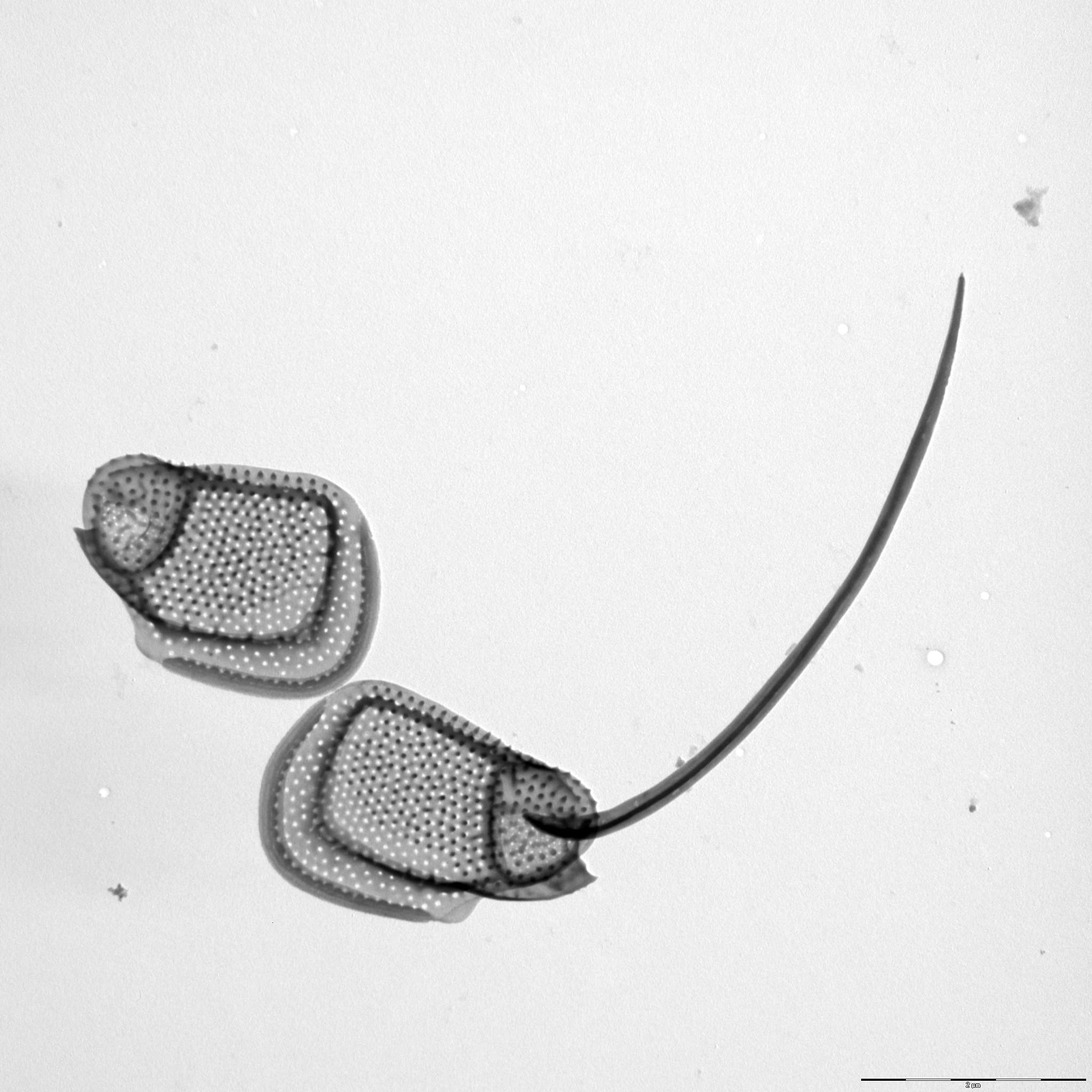
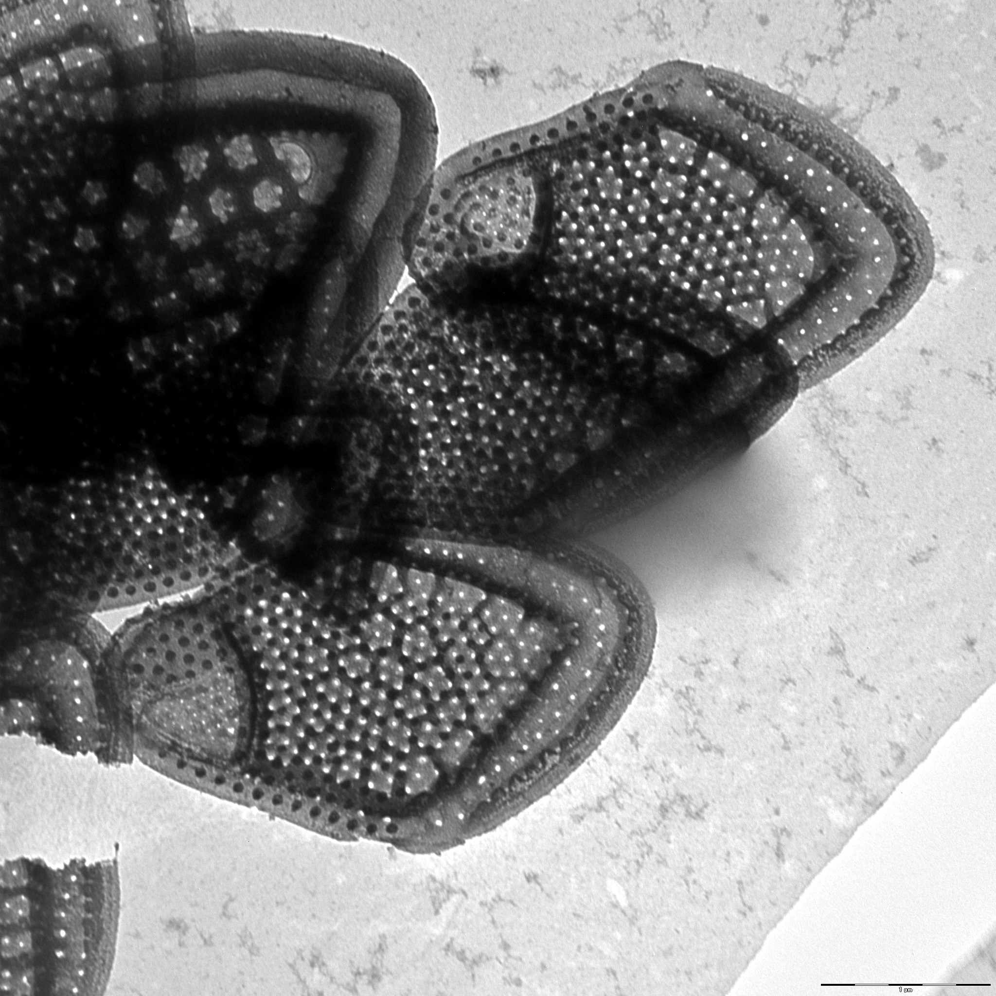
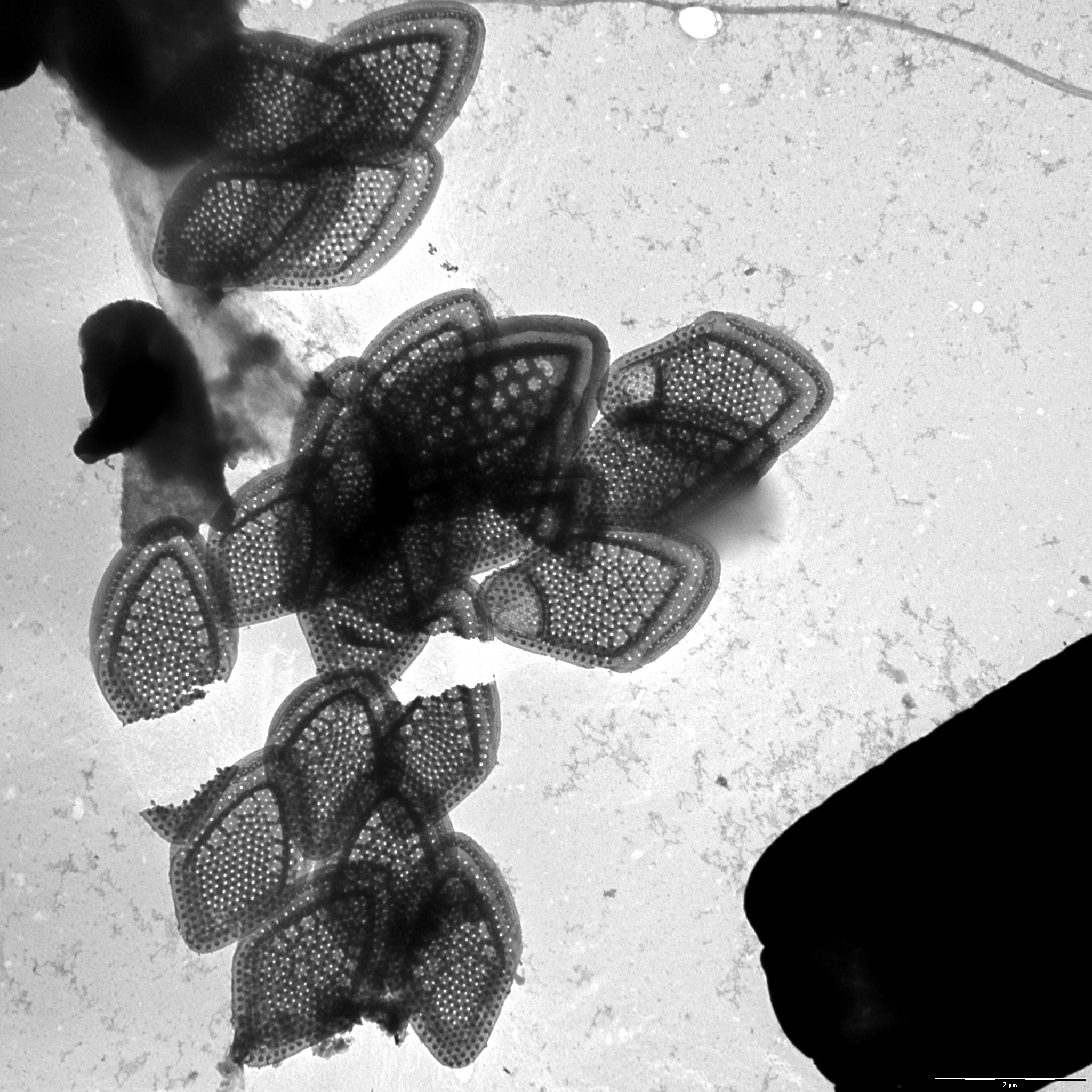
Description: Harris, K. (1967): Variability in Mallomonas. - Journal of General Microbiology 46: 185-191.
Basionym: Mallomonas papillosa f. annulata: Harris, K. & Bradley, D. E. (1960): A taxonomic study of Mallomonas. - Journal of General Microbiology 22: 750-777.
Autecology: pH indifferent, prefers cold water.
Distribution: widely distributed.
Image gallery

List of records
| Locality | Sampling date | pH | Conductivity (μS/cm) | Temperature (°C) | Coordinates | References |
|---|---|---|---|---|---|---|
| Five lakes in Kab-hegyi | 2013 | 47, 17.6 | PADISÁK et al. (2015) | |||
| Křtiny pond | 2020 | 7.6 | 1052 | 12.0 | 50.02565, 14.5350828 | SKALOUD et al. (2025) |
| Spalena Borkovna | 2021 | 6.6 | 126 | 48.9800389, 14.7994933 | SKALOUD et al. (2025) | |
| Vltavský luh | 2002 | 5.3 | 63 | 48.82893, 13.937779 | SEJNOHOVA (2003) | |
| canal of Sutka river | 2019 | 8.5 | 152 | 7.6 | 58.049256, 38.251608 | KAPUSTIN (unpublished) |
| Lake Saarde paisjarv | 2013 | 8.7 | 313 | 19.0 | 58.143496, 24.970324 | CERTNEROVA & SKALOUD (2020) |
| Ahja River | 2013 | 8.0 | 344 | 20.0 | 58.26853, 27.132563 | CERTNEROVA & SKALOUD (2020) |
| Emajoe-Suursoo sookaitseala/maastikukaitseala | 2013 | 6.7 | 157 | 21.0 | 58.335374, 27.263844 | CERTNEROVA & SKALOUD (2020) |
| Kaisma jarv | 2013 | 7.9 | 268 | 20.0 | 58.692999, 24.689986 | CERTNEROVA & SKALOUD (2020) |
| The river Raudna jogi | 2013 | 7.9 | 377 | 13.0 | 58.451234, 25.038077 | CERTNEROVA & SKALOUD (2020) |
Distribution map
Five lakes in Kab-hegyi
Locality:
Five lakes in Kab-hegyi
Coordinates:
47, 17.6
Křtiny pond
Locality:
Křtiny pond
Coordinates:
50.02565, 14.5350828
Spalena Borkovna
Locality:
Spalena Borkovna
Coordinates:
48.9800389, 14.7994933
Vltavský luh
Locality:
Vltavský luh
Coordinates:
48.82893, 13.937779
canal of Sutka river
Locality:
canal of Sutka river
Coordinates:
58.049256, 38.251608
Lake Saarde paisjarv
Locality:
Lake Saarde paisjarv
Coordinates:
58.143496, 24.970324
Ahja River
Locality:
Ahja River
Coordinates:
58.26853, 27.132563
Emajoe-Suursoo sookaitseala/maastikukaitseala
Locality:
Emajoe-Suursoo sookaitseala/maastikukaitseala
Coordinates:
58.335374, 27.263844
Kaisma jarv
Locality:
Kaisma jarv
Coordinates:
58.692999, 24.689986
The river Raudna jogi
Locality:
The river Raudna jogi
Coordinates:
58.451234, 25.038077
River Emajogi
Locality:
River Emajogi
Coordinates:
58.396362, 26.310943
Locality:
Coordinates:
58.396362, 26.310943
Lake Suur Linajarv
Locality:
Lake Suur Linajarv
Coordinates:
58.876229, 26.2743
Möserer See
Locality:
Möserer See
Coordinates:
47.3144, 11.1442
Herzsee
Locality:
Herzsee
Coordinates:
47.248533, 11.455436
Krummsee
Locality:
Krummsee
Coordinates:
47.456636, 11.883465
Schwarzsee
Locality:
Schwarzsee
Coordinates:
47.456155, 12.366958
Gieringer Weiher
Locality:
Gieringer Weiher
Coordinates:
47.4707, 12.3626
pool near Pfrilsee
Locality:
pool near Pfrilsee
Coordinates:
47.597598, 12.151179
Pfrillsee
Locality:
Pfrillsee
Coordinates:
47.594791, 12.149076
Bousquet region, bog near Lac du Bourg
Locality:
Bousquet region, bog near Lac du Bourg
Coordinates:
44.498781, -0.639481
Cazaux-Biscarrosse region, enclosed bay of Étang de Cazaux
Locality:
Cazaux-Biscarrosse region, enclosed bay of Étang de Cazaux
Coordinates:
44.440928, -1.188319
Schönwalder Allee, pond
Locality:
Schönwalder Allee, pond
Coordinates:
52.584017, 13.164439
Rohrpfuhl
Locality:
Rohrpfuhl
Coordinates:
52.597678, 13.161263
Nikolassee
Locality:
Nikolassee
Coordinates:
52.424198, 13.192077
Kuhlake, ditch
Locality:
Kuhlake, ditch
Coordinates:
52.572959, 13.171098
river Havel at Glienicke
Locality:
river Havel at Glienicke
Coordinates:
52.422314, 13.093929
Fauler See, Spandau
Locality:
Fauler See, Spandau
Coordinates:
52.519981, 13.214564
Botanical garden in Berlin, China pond
Locality:
Botanical garden in Berlin, China pond
Coordinates:
52.453558, 13.304905
Saratov reservoir
Locality:
Saratov reservoir
Coordinates:
52.837825, 48.484669
Kuybishevskoye vodokhranilishche, reservoir
Locality:
Kuybishevskoye vodokhranilishche, reservoir
Coordinates:
53.444568, 49.232251
Ivankovo Reservoir
Locality:
Ivankovo Reservoir
Coordinates:
56.753476, 37.096267
Kamskoye Vodokhranilishche, reservoir
Locality:
Kamskoye Vodokhranilishche, reservoir
Coordinates:
58.991067, 56.228027
Rybinskoye Vodokhranilishche, reservoir
Locality:
Rybinskoye Vodokhranilishche, reservoir
Coordinates:
58.450607, 38.2901
river Vaya (approximate coordinates)
Locality:
river Vaya (approximate coordinates)
Coordinates:
57.44274, 45.991567
brackish water of Pojo Bay
Locality:
brackish water of Pojo Bay
Coordinates:
60.041875, 23.493462
Federsee
Locality:
Federsee
Coordinates:
48.084214, 9.627028
Syamozero, Karelia
Locality:
Syamozero, Karelia
Coordinates:
61.962844, 33.083839
Konchezero, Karelia
Locality:
Konchezero, Karelia
Coordinates:
62.138238, 33.978538
Pertozero, Karelia
Locality:
Pertozero, Karelia
Coordinates:
64.458587, 34.00177
Oneshskoye lake, Karelia
Locality:
Oneshskoye lake, Karelia
Coordinates:
61.697687, 35.40802
ditch between Rathjensdorf and Kossau
Locality:
ditch between Rathjensdorf and Kossau
Coordinates:
54.194634, 10.440345
meadow pond west of Plusssee
Locality:
meadow pond west of Plusssee
Coordinates:
54.180879, 10.436136
meadow pond north of Trammer See
Locality:
meadow pond north of Trammer See
Coordinates:
54.181501, 10.42074
fishpond in Rixdorf
Locality:
fishpond in Rixdorf
Coordinates:
54.204424, 10.412586
fishpond in Rixdorf
Locality:
fishpond in Rixdorf
Coordinates:
54.204424, 10.412586
fishpond in Rathjensdorf
Locality:
fishpond in Rathjensdorf
Coordinates:
54.184338, 10.428223
Lebrader Teich
Locality:
Lebrader Teich
Coordinates:
54.220536, 10.428421
Grosser Binnensee
Locality:
Grosser Binnensee
Coordinates:
54.325434, 10.622821
Oberer Ausgrabensee
Locality:
Oberer Ausgrabensee
Coordinates:
54.177432, 10.446446
Neversdorfer See
Locality:
Neversdorfer See
Coordinates:
53.867839, 10.265601
Vierer See
Locality:
Vierer See
Coordinates:
54.131265, 10.448842
Heidensee
Locality:
Heidensee
Coordinates:
54.139563, 10.473139
Plusssee inlet, west
Locality:
Plusssee inlet, west
Coordinates:
54.182267, 10.440969
Plusssee
Locality:
Plusssee
Coordinates:
54.182003, 10.443957
Schmarksee
Locality:
Schmarksee
Coordinates:
54.183359, 10.487001
Tresdorfer See
Locality:
Tresdorfer See
Coordinates:
54.233029, 10.467088
Kleiner Plöner See
Locality:
Kleiner Plöner See
Coordinates:
54.160047, 10.392416
Kellersee
Locality:
Kellersee
Coordinates:
54.173589, 10.594153
Nikolassee
Locality:
Nikolassee
Coordinates:
52.424146, 13.192077
lake Trummen
Locality:
lake Trummen
Coordinates:
56.862018, 14.829819
Waschsee
Locality:
Waschsee
Coordinates:
47.772301, 11.319115
Schiffhüttensee
Locality:
Schiffhüttensee
Coordinates:
47.773945, 11.317545
Bergsee
Locality:
Bergsee
Coordinates:
47.57143, 7.936406
Feisnitzspeicher
Locality:
Feisnitzspeicher
Coordinates:
50.034265, 12.17783
Silbersee
Locality:
Silbersee
Coordinates:
49.412481, 12.596984
Eixendorfer Speicher
Locality:
Eixendorfer Speicher
Coordinates:
49.339441, 12.445965
Kis-Jusztus swamp, temporary
Locality:
Kis-Jusztus swamp, temporary
Coordinates:
47.57502, 21.022854
fishpond between Pat and Nemesdéd
Locality:
fishpond between Pat and Nemesdéd
Coordinates:
46.432385, 17.218396
angler pond between Miháld and Pat
Locality:
angler pond between Miháld and Pat
Coordinates:
46.450927, 17.152956
Kis-Balaton reservoir
Locality:
Kis-Balaton reservoir
Coordinates:
46.628221, 17.151604
small pond, 2.5 km south from Sármellék, at the road towards Balatonmagyaród
Locality:
small pond, 2.5 km south from Sármellék, at the road towards Balatonmagyaród
Coordinates:
46.682892, 17.169714
Rókás, backwater of the Danube
Locality:
Rókás, backwater of the Danube
Coordinates:
47.094319, 18.922648
small groundwater pond before entering Szigetcsép, at the road coming from Tököl
Locality:
small groundwater pond before entering Szigetcsép, at the road coming from Tököl
Coordinates:
47.272561, 18.975512
alluvial pools, Lužnice River
Locality:
alluvial pools, Lužnice River
Coordinates:
48.835123, 14.927174
alluvial pools, Lužnice River, Mallomonas in years 2000-2003
Locality:
alluvial pools, Lužnice River, Mallomonas in years 2000-2003
Coordinates:
48.810255, 14.930763
Égeres, small temporary forest pond, Pilis/Visegrád Mountains, Király-valley (approx.)
Locality:
Égeres, small temporary forest pond, Pilis/Visegrád Mountains, Király-valley (approx.)
Coordinates:
47.74, 18.92
lake Pamvotis
Locality:
lake Pamvotis
Coordinates:
39.671785, 20.877056
Ølene
Locality:
Ølene
Coordinates:
55.100987, 15.014012
various localities within 30 miles from Edinburgh, Scotland
Locality:
various localities within 30 miles from Edinburgh, Scotland
Coordinates:
55.953237, -3.188782
small pond in mountain grassland, Visegrád mountains
Locality:
small pond in mountain grassland, Visegrád mountains
Coordinates:
47.72682, 19.01658
small bog pond in the Visegrád mountains
Locality:
small bog pond in the Visegrád mountains
Coordinates:
47.713521, 19.040333
small bog pond in the middle of an alder forest, Visegrád mountains
Locality:
small bog pond in the middle of an alder forest, Visegrád mountains
Coordinates:
47.707497, 19.040247
Kis-Balaton reservoir
Locality:
Kis-Balaton reservoir
Coordinates:
46.635294, 17.146111
Näsijärvi
Locality:
Näsijärvi
Coordinates:
61.699965, 23.753014
Hestehavedam
Locality:
Hestehavedam
Coordinates:
55.241466, 14.790577
Tystrup Sø
Locality:
Tystrup Sø
Coordinates:
55.369356, 11.570606
Långträsk, Åland
Locality:
Långträsk, Åland
Coordinates:
60.169183, 19.788237
Zeller Loch, Fulda
Locality:
Zeller Loch, Fulda
Coordinates:
50.513392, 9.620998
Molenwiel
Locality:
Molenwiel
Coordinates:
51.770605, 5.754626
Petersven at Valkenswaard, moorland pool with Sphagnum
Locality:
Petersven at Valkenswaard, moorland pool with Sphagnum
Coordinates:
51.36803, 5.467973
ditch near Ooyendonk
Locality:
ditch near Ooyendonk
Coordinates:
51.610342, 5.325108
brook Beerze
Locality:
brook Beerze
Coordinates:
51.597174, 5.275154
Oisterwijkse Vennen, group of moorland pools, Staalbergsven
Locality:
Oisterwijkse Vennen, group of moorland pools, Staalbergsven
Coordinates:
51.57301, 5.222797
pool near pond-Loampit near Udenhout
Locality:
pool near pond-Loampit near Udenhout
Coordinates:
51.608903, 5.182114
ditch system near Haarsteegse Wiel, pH 6.3.-7.9
Locality:
ditch system near Haarsteegse Wiel, pH 6.3.-7.9
Coordinates:
51.718946, 5.18383
cut-off branch of the river Meuse, Grote Vilt
Locality:
cut-off branch of the river Meuse, Grote Vilt
Coordinates:
51.679687, 5.930557
small pool near Shayk (Shaijk)
Locality:
small pool near Shayk (Shaijk)
Coordinates:
51.741433, 5.632467
drinking pool between Mill and Beers
Locality:
drinking pool between Mill and Beers
Coordinates:
51.691288, 5.78825
Broekse Wielen IV., pond near the river Meuse
Locality:
Broekse Wielen IV., pond near the river Meuse
Coordinates:
51.728889, 5.763788
Broekse Wielen II., pond near the river Meuse
Locality:
Broekse Wielen II., pond near the river Meuse
Coordinates:
51.728889, 5.763788
Broekse Wielen I., pond near the river Meuse
Locality:
Broekse Wielen I., pond near the river Meuse
Coordinates:
51.728889, 5.763788
Bosbeek, a brook about 1 km from its origin
Locality:
Bosbeek, a brook about 1 km from its origin
Coordinates:
51.171244, 6.107883
pool near Dutch-German border
Locality:
pool near Dutch-German border
Coordinates:
51.186445, 6.157666
small pond at playgrounds in Nijmegen
Locality:
small pond at playgrounds in Nijmegen
Coordinates:
51.831322, 5.812454
pond E of the Oude Waal
Locality:
pond E of the Oude Waal
Coordinates:
51.855052, 5.897727
Immerlooplas
Locality:
Immerlooplas
Coordinates:
51.955189, 5.91485
pond F of the Oude Waal, pH neutral to slightly alkaline
Locality:
pond F of the Oude Waal, pH neutral to slightly alkaline
Coordinates:
51.855847, 5.900259
pond F of the Oude Waal, pH neutral to slightly alkaline
Locality:
pond F of the Oude Waal, pH neutral to slightly alkaline
Coordinates:
51.855847, 5.900259
pond D of the Oude Waal, pH neutral to slightly alkaline
Locality:
pond D of the Oude Waal, pH neutral to slightly alkaline
Coordinates:
51.853091, 5.896783
eutrophic peat bogs near Salicea (Cluj)
Locality:
eutrophic peat bogs near Salicea (Cluj)
Coordinates:
46.676867, 23.52536
Szeremlei holtág, a sluice on backwater of the R. Danube at Baja city
Locality:
Szeremlei holtág, a sluice on backwater of the R. Danube at Baja city
Coordinates:
46.168874, 18.941966
Mestecănişul de la Reci, spring and autumn 1996 and 1997
Locality:
Mestecănişul de la Reci, spring and autumn 1996 and 1997
Coordinates:
45.822582, 25.926525
Baláta-tó, bog lake complex, shallow waters among sedge humocks and floating peat islands, after ice melting
Locality:
Baláta-tó, bog lake complex, shallow waters among sedge humocks and floating peat islands, after ice melting
Coordinates:
46.311011, 17.207508
roadside Caricetum II. (temporary water)
Locality:
roadside Caricetum II. (temporary water)
Coordinates:
47.582605, 21.129155
Brehynsky pond
Locality:
Brehynsky pond
Coordinates:
50.579167, 14.703611
Madriz puddle
Locality:
Madriz puddle
Coordinates:
40.179431, -8.688576
Quinhendros marsh
Locality:
Quinhendros marsh
Coordinates:
40.128101, -8.635745
Quinhendros marsh
Locality:
Quinhendros marsh
Coordinates:
40.128101, -8.635745
the Kachní Stream, an upper reach near the origin and a lower re
Locality:
the Kachní Stream, an upper reach near the origin and a lower re
Coordinates:
50.860556, 14.309167
T2 pool
Locality:
T2 pool
Coordinates:
48.835123, 14.927174
T2 pool
Locality:
T2 pool
Coordinates:
48.835123, 14.927174
T2 pool
Locality:
T2 pool
Coordinates:
48.835123, 14.927174
T2 pool
Locality:
T2 pool
Coordinates:
48.835123, 14.927174
T2 pool
Locality:
T2 pool
Coordinates:
48.835123, 14.927174
oxbow lake Krnak, Berounka, Zbraslav
Locality:
oxbow lake Krnak, Berounka, Zbraslav
Coordinates:
49.979902, 14.394364
Vidlak pond
Locality:
Vidlak pond
Coordinates:
50.521759, 15.210732
Rokytnicky pond
Locality:
Rokytnicky pond
Coordinates:
50.530558, 15.221515
Reka pond
Locality:
Reka pond
Coordinates:
49.671738, 15.848808
Ransky pond
Locality:
Ransky pond
Coordinates:
49.683124, 15.83293
Sabrava brook
Locality:
Sabrava brook
Coordinates:
49.556966, 15.915574
pool near Matejovsky pond
Locality:
pool near Matejovsky pond
Coordinates:
49.540132, 15.896434
Matejovsky pond
Locality:
Matejovsky pond
Coordinates:
49.538912, 15.888805
Velke Darko pond
Locality:
Velke Darko pond
Coordinates:
49.632896, 15.902195
Macha lake
Locality:
Macha lake
Coordinates: