List of species
-
Mallomonas
-
a
- Mallomonas acaroides
- Mallomonas acaroides var. inermis
- Mallomonas actinoloma
- Mallomonas actinoloma var. maramuresensis
- Mallomonas actinoloma var. nadiensis
- Mallomonas adamas
- Mallomonas akrokomos
- Mallomonas alata
- Mallomonas allorgei
- Mallomonas alphaphora
- Mallomonas alpina
- Mallomonas alveolata
- Mallomonas annulata
- Mallomonas areolata
-
b - c
- Mallomonas balonovii
- Mallomonas bangladeshica
- Mallomonas calceolus
- Mallomonas canina
- Mallomonas caudata
- Mallomonas clavus
- Mallomonas conspersa
- Mallomonas corcontica
- Mallomonas corymbosa
- Mallomonas costata
- Mallomonas crassisquama
- Mallomonas crassisquama var. papillosa
- Mallomonas cratis
- Mallomonas cristata
- Mallomonas cucullata
- Mallomonas cyathellata
- d - g
- h - k
-
l - m
- Mallomonas labyrinthina
- Mallomonas leboimei
- Mallomonas lelymene
- Mallomonas lychenensis
- Mallomonas lychenensis f. symposiaca
- Mallomonas maculata
- Mallomonas mangofera
- Mallomonas mangofera var. gracilis
- Mallomonas mangofera var. reticulata
- Mallomonas matvienkoae
- Mallomonas multisetigera
- Mallomonas multiunca
- Mallomonas munda
- o - ph
-
pi - pu
- Mallomonas pillula
- Mallomonas pillula f. exannulata
- Mallomonas pillula f. latimarginalis
- Mallomonas pillula f. valdiviana
- Mallomonas portae-ferreae
- Mallomonas prora
- Mallomonas pseudocoronata
- Mallomonas pseudocratis
- Mallomonas pugio
- Mallomonas pumilio
- Mallomonas pumilio var. dispersa
- Mallomonas punctifera
- Mallomonas punctifera var. brasiliensis
- r - s
- t - z
-
a
-
Synura
- a - g
- h - m
- n - u
- Neotessella
-
Paraphysomonas
- a - ci
- co - h
- i - q
- r - v
-
Lepidochromonas
- c - i
-
m - u
- Lepidochromonas manubriata
- Lepidochromonas morchella
- Lepidochromonas poteriophora
- Lepidochromonas quadrispina
- Lepidochromonas runcinifera
- Lepidochromonas sigillifera
- Lepidochromonas stelligera
- Lepidochromonas stephanolepis
- Lepidochromonas subquadrangularis
- Lepidochromonas subrotacea
- Lepidochromonas takahashii
- Lepidochromonas undulata
-
Spiniferomonas
- a - c
- m - t
- Chrysosphaerella
- Polylepidomonas
Search
General information
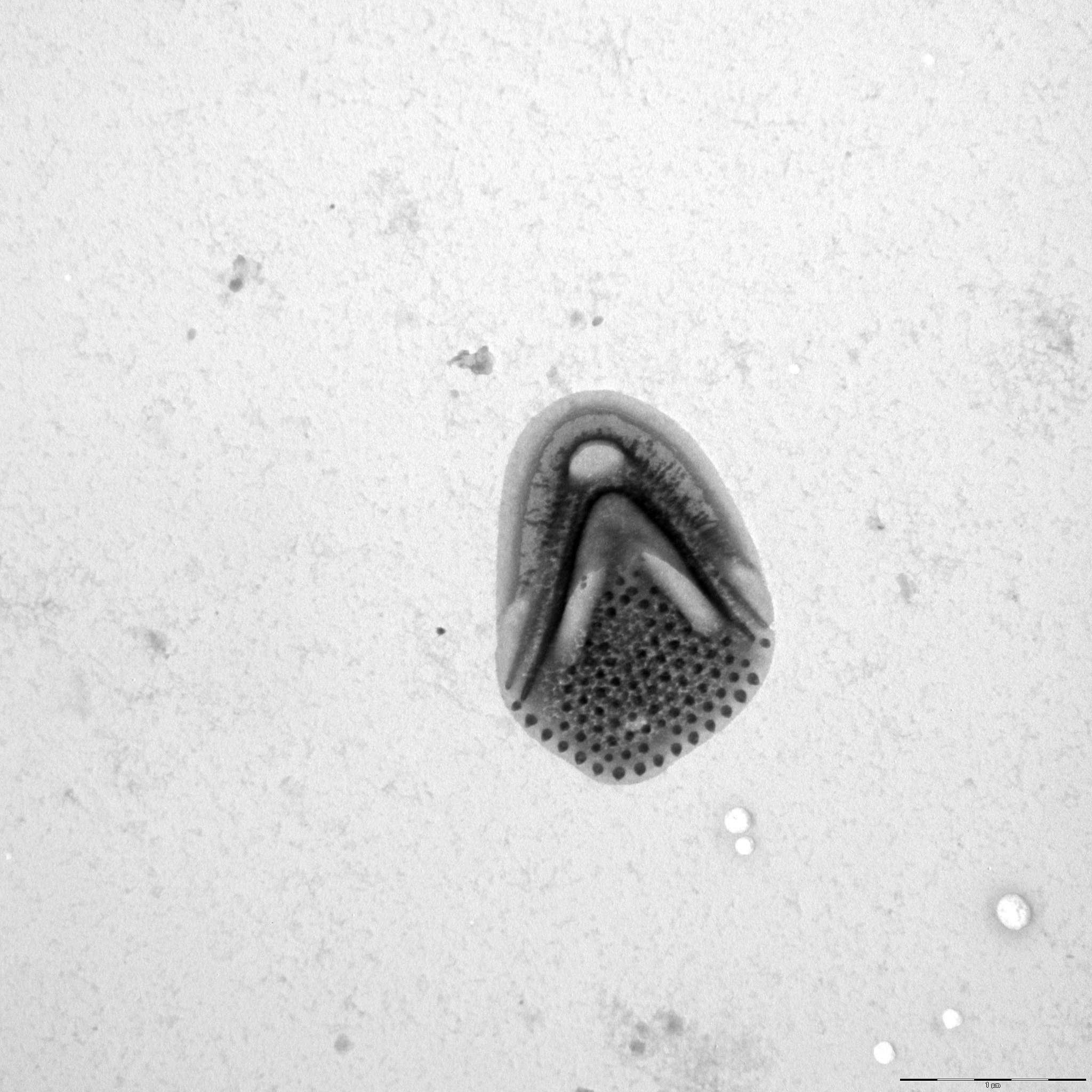
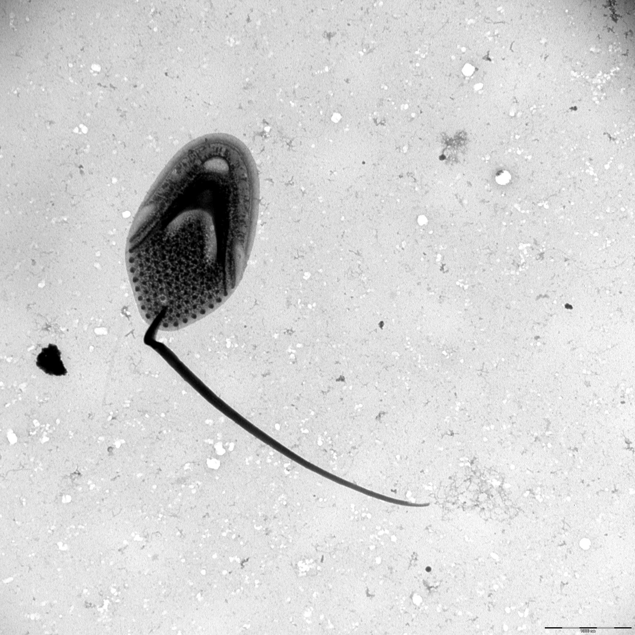
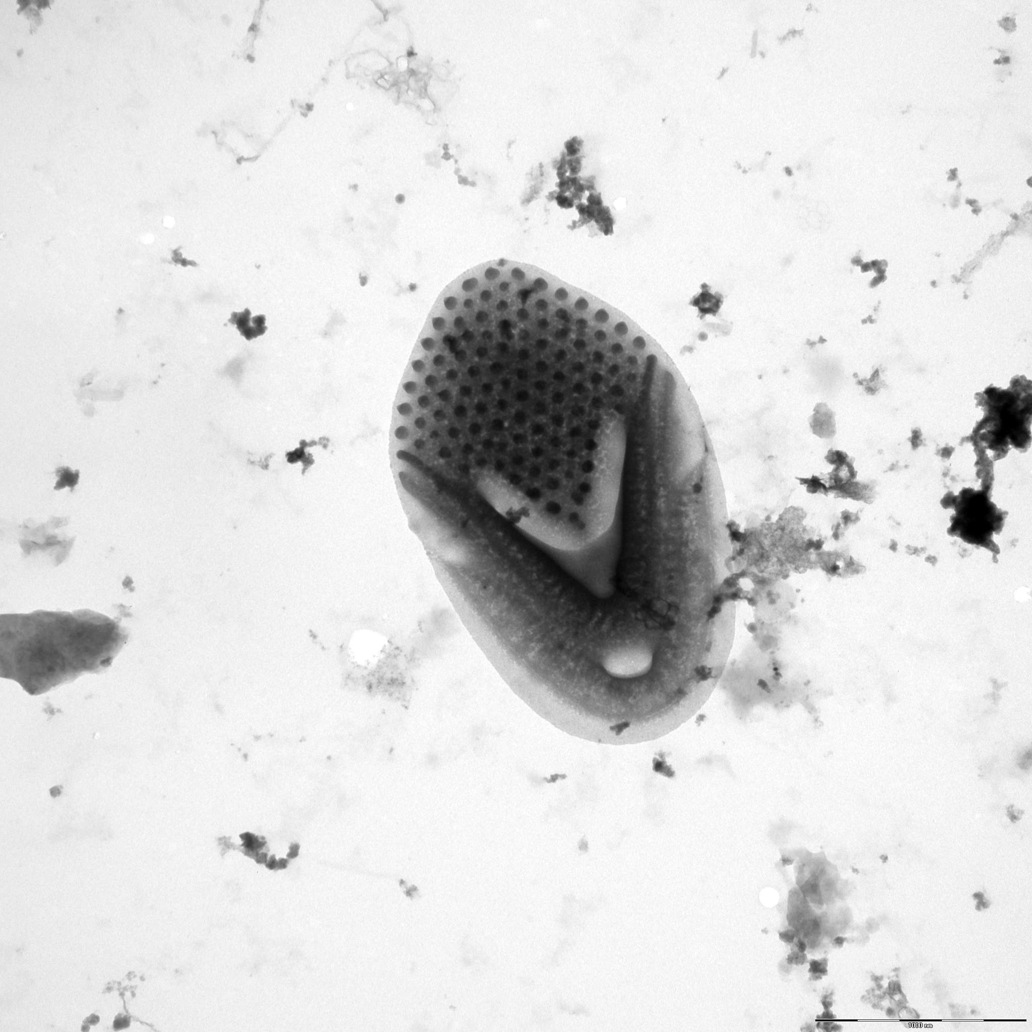
Description: Dürrschmidt, M. (1982): Studies on the Chrysophyceae from South Chilean inland waters by means of scanning and transmission electron microscopy, II. Arch. Hydrobiol. /Algological Studies 63,2: 121-163.
Autecology: alkaliphilic to pH indifferent, mesotrophic.
Distribution: widely distributed.
Image gallery

List of records
| Locality | Sampling date | pH | Conductivity (μS/cm) | Temperature (°C) | Coordinates | References |
|---|---|---|---|---|---|---|
| Five lakes in Kab-hegyi | 2013 | 47, 17.6 | PADISÁK et al. (2015) | |||
| forest pond | 2020 | 6.6 | 320 | 9.0 | 49.9800311, 12.7870547 | SKALOUD et al. (2025) |
| Spalena Borkovna | 2021 | 6.6 | 126 | 48.9800389, 14.7994933 | SKALOUD et al. (2025) | |
| Egelsee | 2012 | 8.1 | 309 | 12.6 | 47.613107, 12.170277 | PICHRTOVÁ et al. (2013) |
| Hechtsee | 2012 | 8.5 | 337 | 12.0 | 47.609056, 12.165298 | PICHRTOVÁ et al. (2013) |
| Léon-Soustons region, Étang de Soustons | 2010 | 7.3 | 178 | 9.5 | 43.758367, -1.337686 | NEMCOVA et al. (2012) |
| léon-Soustons region, small lake between Étang du Houa and Étang de Léon | 2010 | 7.2 | 123 | 17.5 | 43.894222, -1.303278 | NEMCOVA et al. (2012) |
| Bousquet region, wetland near Lac du Bourg | 2010 | 6.9 | 224 | 25.8 | 44.498583, -0.639417 | NEMCOVA et al. (2012) |
| Bousquet region, Marais du Cla, small pool | 2010 | 5.6 | 126 | 23.9 | 44.515806, -0.607528 | NEMCOVA et al. (2012) |
| Cazaux-Biscarrosse region, enclosed bay of Étang de Cazaux | 2010 | 6.8 | 236 | 44.440928, -1.188319 | NEMCOVA et al. (2012) |
Distribution map
Five lakes in Kab-hegyi
Locality:
Five lakes in Kab-hegyi
Coordinates:
47, 17.6
forest pond
Locality:
forest pond
Coordinates:
49.9800311, 12.7870547
Spalena Borkovna
Locality:
Spalena Borkovna
Coordinates:
48.9800389, 14.7994933
Egelsee
Locality:
Egelsee
Coordinates:
47.613107, 12.170277
Hechtsee
Locality:
Hechtsee
Coordinates:
47.609056, 12.165298
Léon-Soustons region, Étang de Soustons
Locality:
Léon-Soustons region, Étang de Soustons
Coordinates:
43.758367, -1.337686
léon-Soustons region, small lake between Étang du Houa and Étang de Léon
Locality:
léon-Soustons region, small lake between Étang du Houa and Étang de Léon
Coordinates:
43.894222, -1.303278
Bousquet region, wetland near Lac du Bourg
Locality:
Bousquet region, wetland near Lac du Bourg
Coordinates:
44.498583, -0.639417
Bousquet region, Marais du Cla, small pool
Locality:
Bousquet region, Marais du Cla, small pool
Coordinates:
44.515806, -0.607528
Cazaux-Biscarrosse region, enclosed bay of Étang de Cazaux
Locality:
Cazaux-Biscarrosse region, enclosed bay of Étang de Cazaux
Coordinates:
44.440928, -1.188319
Lacanau region, Étang de Lacanau
Locality:
Lacanau region, Étang de Lacanau
Coordinates:
44.971583, -1.098028
Rohrpfuhl
Locality:
Rohrpfuhl
Coordinates:
52.597678, 13.161263
Nikolassee
Locality:
Nikolassee
Coordinates:
52.424198, 13.192077
Kuhlake, ditch
Locality:
Kuhlake, ditch
Coordinates:
52.572959, 13.171098
river Havel at Glienicke
Locality:
river Havel at Glienicke
Coordinates:
52.422314, 13.093929
Fauler See, Spandau
Locality:
Fauler See, Spandau
Coordinates:
52.519981, 13.214564
Federsee
Locality:
Federsee
Coordinates:
48.084214, 9.627028
ditch between Rathjensdorf and Kossau
Locality:
ditch between Rathjensdorf and Kossau
Coordinates:
54.194634, 10.440345
meadow pond west of Plusssee
Locality:
meadow pond west of Plusssee
Coordinates:
54.180879, 10.436136
fishpond in Rixdorf
Locality:
fishpond in Rixdorf
Coordinates:
54.204424, 10.412586
fishpond in Rixdorf
Locality:
fishpond in Rixdorf
Coordinates:
54.204424, 10.412586
fishpond in Rathjensdorf
Locality:
fishpond in Rathjensdorf
Coordinates:
54.185362, 10.431452
Lebrader Teich
Locality:
Lebrader Teich
Coordinates:
54.220536, 10.428421
Grosser Binnensee
Locality:
Grosser Binnensee
Coordinates:
54.325434, 10.622821
Garrensee
Locality:
Garrensee
Coordinates:
53.687813, 10.850193
Vierer See
Locality:
Vierer See
Coordinates:
54.131265, 10.448842
Heidensee
Locality:
Heidensee
Coordinates:
54.139563, 10.473139
Plusssee inlet, west
Locality:
Plusssee inlet, west
Coordinates:
54.182267, 10.440969
Nikolassee
Locality:
Nikolassee
Coordinates:
52.424146, 13.192077
Waschsee
Locality:
Waschsee
Coordinates:
47.772301, 11.319115
Schiffhüttensee
Locality:
Schiffhüttensee
Coordinates:
47.773945, 11.317545
swamp in Vindornyaszölös
Locality:
swamp in Vindornyaszölös
Coordinates:
46.905832, 17.167211
Kis-Balaton reservoir
Locality:
Kis-Balaton reservoir
Coordinates:
46.628221, 17.151604
small pond, 2.5 km south from Sármellék, at the road towards Balatonmagyaród
Locality:
small pond, 2.5 km south from Sármellék, at the road towards Balatonmagyaród
Coordinates:
46.682892, 17.169714
alluvial pools, Lužnice River, Mallomonas in years 2000-2003
Locality:
alluvial pools, Lužnice River, Mallomonas in years 2000-2003
Coordinates:
48.810255, 14.930763
various localities within 30 miles from Edinburgh, Scotland
Locality:
various localities within 30 miles from Edinburgh, Scotland
Coordinates:
55.953237, -3.188782
Kis-Balaton reservoir
Locality:
Kis-Balaton reservoir
Coordinates:
46.635294, 17.146111
8 lakes in Pyhä-Häkki National Park
Locality:
8 lakes in Pyhä-Häkki National Park
Coordinates:
62.848253, 25.467625
Tystrup Sø
Locality:
Tystrup Sø
Coordinates:
55.369356, 11.570606
St. Jansberg
Locality:
St. Jansberg
Coordinates:
51.737813, 5.922781
Geuldert
Locality:
Geuldert
Coordinates:
51.737651, 5.929827
Erpewaai III
Locality:
Erpewaai III
Coordinates:
51.761054, 5.827293
brook Beerze
Locality:
brook Beerze
Coordinates:
51.597174, 5.275154
Loampit near Udenhout, pond
Locality:
Loampit near Udenhout, pond
Coordinates:
51.608903, 5.182114
Haarsteegse Wiel: harbour
Locality:
Haarsteegse Wiel: harbour
Coordinates:
51.718946, 5.18383
Broekse Wielen II., pond near the river Meuse
Locality:
Broekse Wielen II., pond near the river Meuse
Coordinates:
51.728889, 5.763788
Broekse Wielen I., pond near the river Meuse
Locality:
Broekse Wielen I., pond near the river Meuse
Coordinates:
51.728889, 5.763788
Immerlooplas
Locality:
Immerlooplas
Coordinates:
51.955189, 5.91485
pond D of the Oude Waal, pH neutral to slightly alkaline
Locality:
pond D of the Oude Waal, pH neutral to slightly alkaline
Coordinates:
51.853091, 5.896783
Province of Limburg, St. Jansberg
Locality:
Province of Limburg, St. Jansberg
Coordinates:
51.737813, 5.922781
Lake Ladoga, Svir Bay, station 17
Locality:
Lake Ladoga, Svir Bay, station 17
Coordinates:
60.543775, 32.667847
Quinhendros marsh
Locality:
Quinhendros marsh
Coordinates:
40.128101, -8.635745
Quinhendros marsh
Locality:
Quinhendros marsh
Coordinates:
40.128101, -8.635745
T2 pool
Locality:
T2 pool
Coordinates:
48.835123, 14.927174
Brehyne pond
Locality:
Brehyne pond
Coordinates: