List of species
-
Mallomonas
-
a
- Mallomonas acaroides
- Mallomonas acaroides var. inermis
- Mallomonas actinoloma
- Mallomonas actinoloma var. maramuresensis
- Mallomonas actinoloma var. nadiensis
- Mallomonas adamas
- Mallomonas akrokomos
- Mallomonas alata
- Mallomonas allorgei
- Mallomonas alphaphora
- Mallomonas alpina
- Mallomonas alveolata
- Mallomonas annulata
- Mallomonas areolata
-
b - c
- Mallomonas balonovii
- Mallomonas bangladeshica
- Mallomonas calceolus
- Mallomonas canina
- Mallomonas caudata
- Mallomonas clavus
- Mallomonas conspersa
- Mallomonas corcontica
- Mallomonas corymbosa
- Mallomonas costata
- Mallomonas crassisquama
- Mallomonas crassisquama var. papillosa
- Mallomonas cratis
- Mallomonas cristata
- Mallomonas cucullata
- Mallomonas cyathellata
- d - g
- h - k
-
l - m
- Mallomonas labyrinthina
- Mallomonas leboimei
- Mallomonas lelymene
- Mallomonas lychenensis
- Mallomonas lychenensis f. symposiaca
- Mallomonas maculata
- Mallomonas mangofera
- Mallomonas mangofera var. gracilis
- Mallomonas mangofera var. reticulata
- Mallomonas matvienkoae
- Mallomonas multisetigera
- Mallomonas multiunca
- Mallomonas munda
- o - ph
-
pi - pu
- Mallomonas pillula
- Mallomonas pillula f. exannulata
- Mallomonas pillula f. latimarginalis
- Mallomonas pillula f. valdiviana
- Mallomonas portae-ferreae
- Mallomonas prora
- Mallomonas pseudocoronata
- Mallomonas pseudocratis
- Mallomonas pugio
- Mallomonas pumilio
- Mallomonas pumilio var. dispersa
- Mallomonas punctifera
- Mallomonas punctifera var. brasiliensis
- r - s
- t - z
-
a
-
Synura
- a - g
- h - m
- n - u
- Neotessella
-
Paraphysomonas
- a - ci
- co - h
- i - q
- r - v
-
Lepidochromonas
- c - i
-
m - u
- Lepidochromonas manubriata
- Lepidochromonas morchella
- Lepidochromonas poteriophora
- Lepidochromonas quadrispina
- Lepidochromonas runcinifera
- Lepidochromonas sigillifera
- Lepidochromonas stelligera
- Lepidochromonas stephanolepis
- Lepidochromonas subquadrangularis
- Lepidochromonas subrotacea
- Lepidochromonas takahashii
- Lepidochromonas undulata
-
Spiniferomonas
- a - c
- m - t
- Chrysosphaerella
- Polylepidomonas
Search
General information
Description: Saedeleer, H. de (1929): Notules systématiques. VI. Physomonas. Ann. Protistol. 2: 177-178.
Basionym: Physomonas vestita A.C.Stokes 1885
Autecology: acidophilic to pH indifferent, temperature tolerant.
Distribution: cosmopolitan, widely distributed.
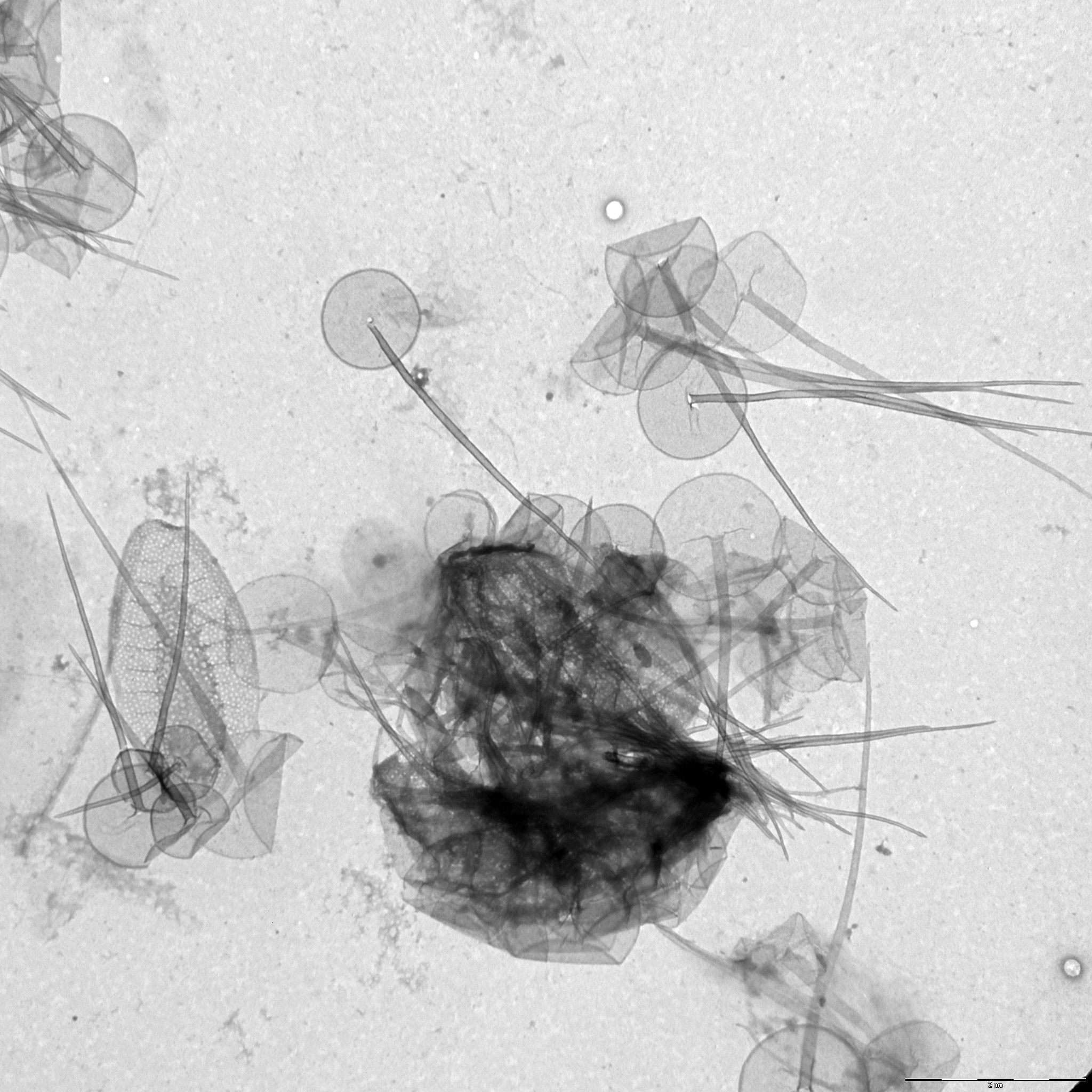
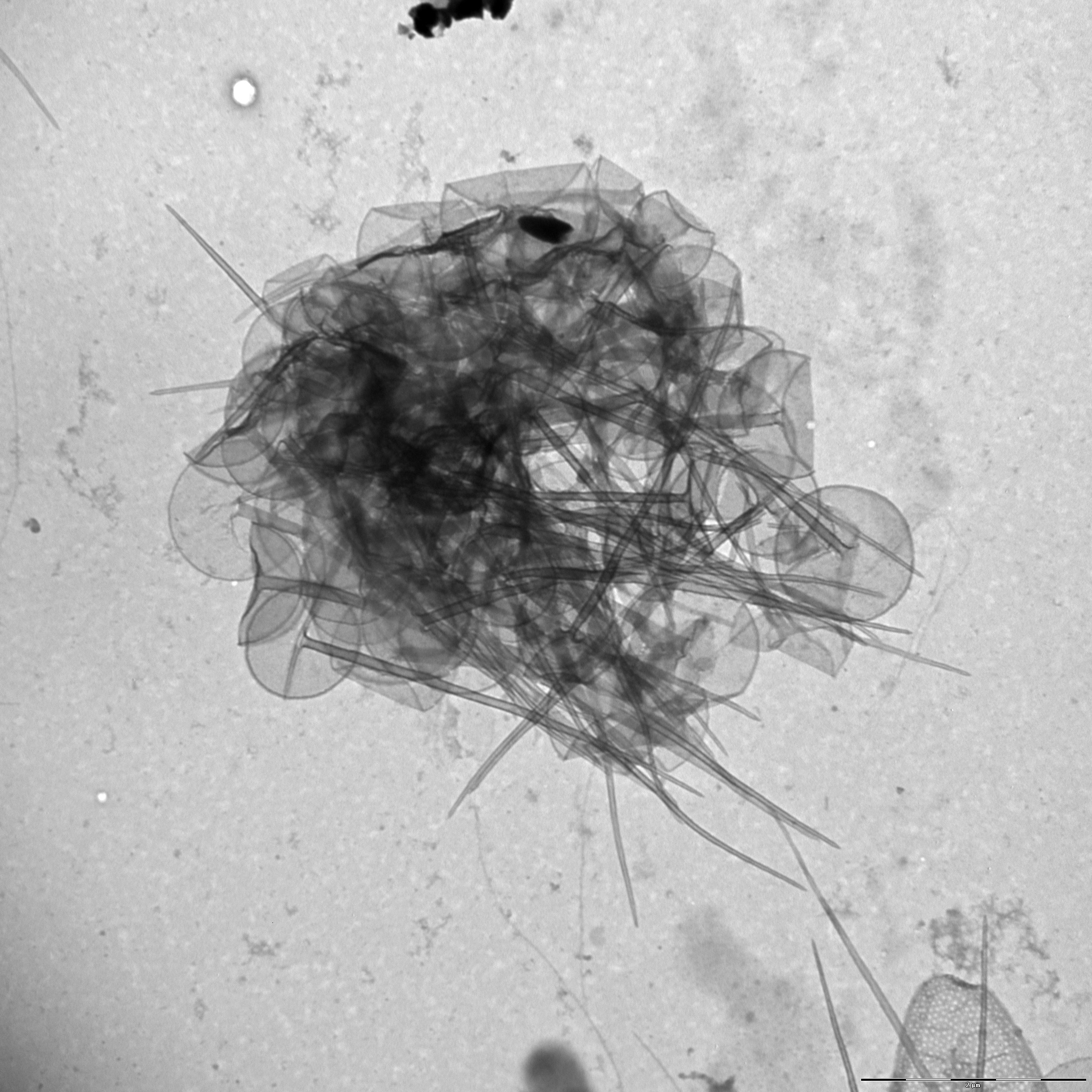
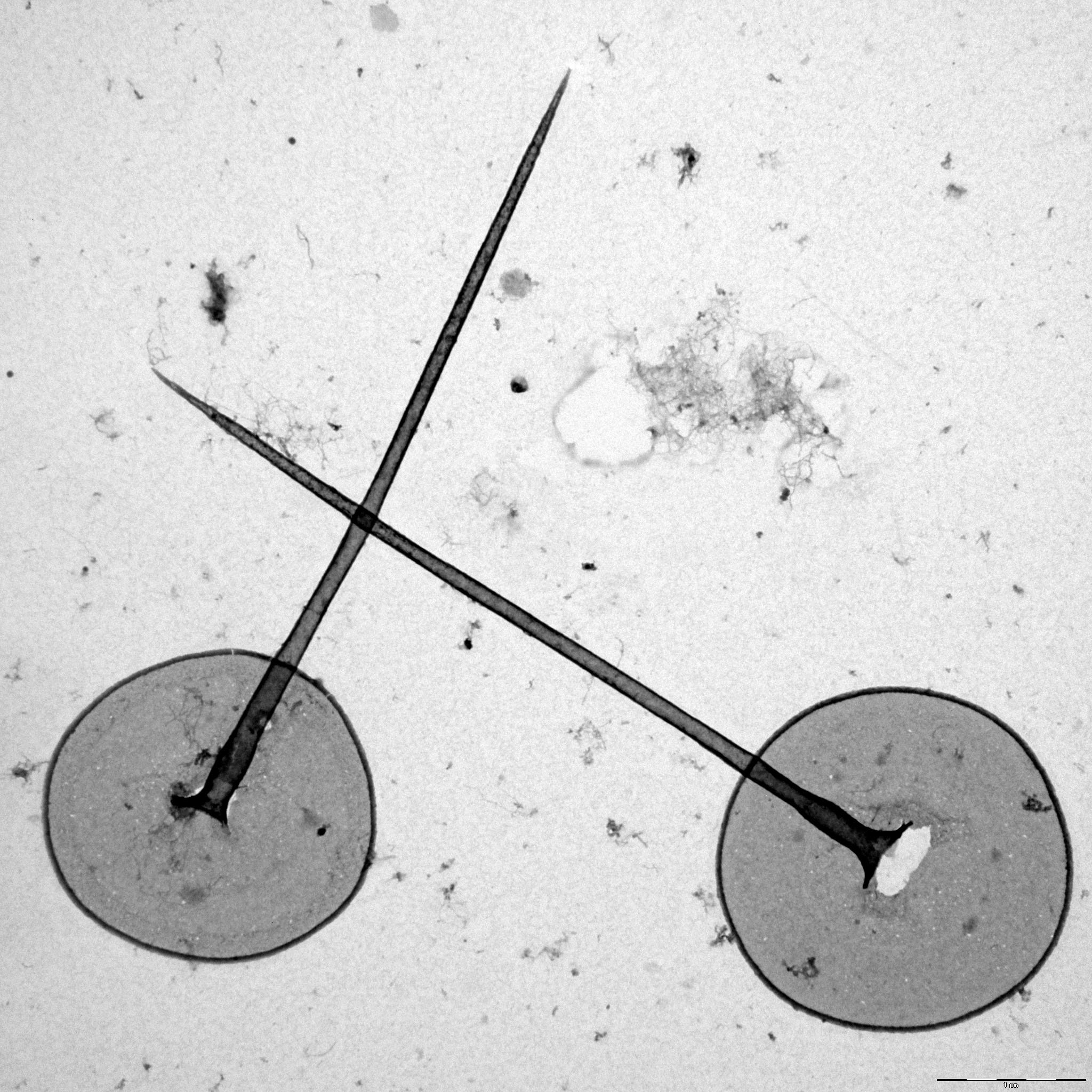
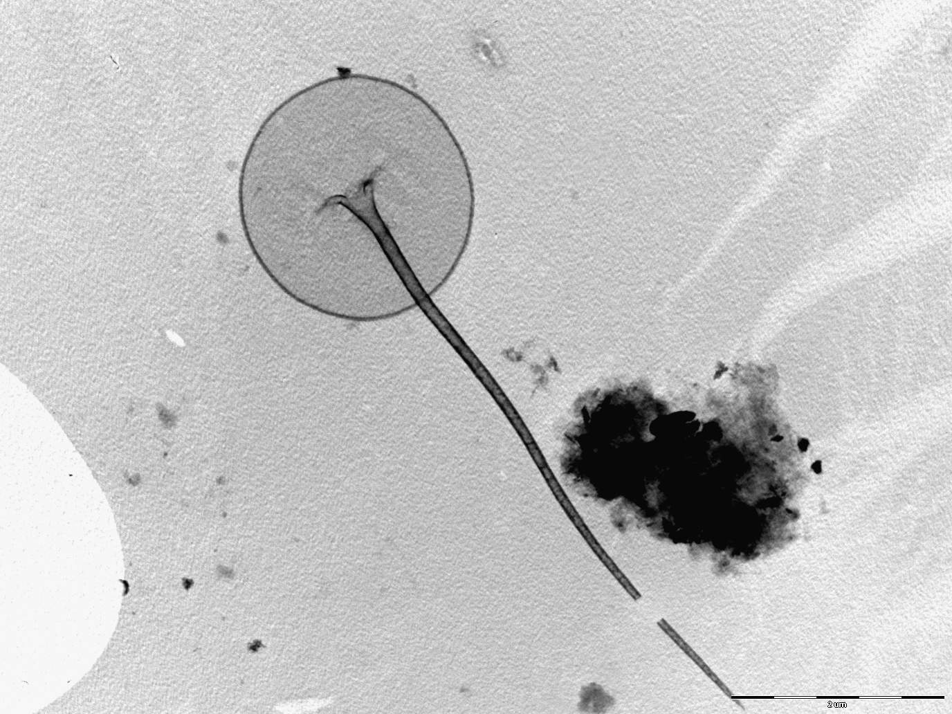
Image gallery
List of records
| Locality | Sampling date | pH | Conductivity (μS/cm) | Temperature (°C) | Coordinates | References |
|---|---|---|---|---|---|---|
| Five lakes in Kab-hegyi | 2013 | 47, 17.6 | PADISÁK et al. (2015) | |||
| Kropfsee | 2012 | 8.5 | 354 | 14.6 | 47.273, 10.8034 | PICHRTOVÁ et al. (2013) |
| fishpond near Mauschlhütte | 2012 | 47.275415, 10.808101 | PICHRTOVÁ et al. (2013) | |||
| Amberger See | 2012 | 5.9 | 16 | 6.3 | 47.226, 10.8853 | PICHRTOVÁ et al. (2013) |
| Piburger See | 2012 | 7.5 | 71 | 8.3 | 47.1952, 10.8861 | PICHRTOVÁ et al. (2013) |
| Seefelder See (Wildsee) | 2012 | 8.1 | 414 | 7.1 | 47.3224, 11.192 | PICHRTOVÁ et al. (2013) |
| Möserer See | 2012 | 8.2 | 371 | 5.8 | 47.3144, 11.1442 | PICHRTOVÁ et al. (2013) |
| Baggersee Rossau | 2012 | 8.2 | 673 | 12.6 | 47.2653, 11.4458 | PICHRTOVÁ et al. (2013) |
| Seerosenweiher | 2012 | 7.7 | 377 | 12.1 | 47.243, 11.419 | PICHRTOVÁ et al. (2013) |
| Brennersee | 2012 | 8.3 | 587 | 9.0 | 47.0171, 11.5037 | PICHRTOVÁ et al. (2013) |
Distribution map
Five lakes in Kab-hegyi
Locality:
Five lakes in Kab-hegyi
Coordinates:
47, 17.6
Kropfsee
Locality:
Kropfsee
Coordinates:
47.273, 10.8034
fishpond near Mauschlhütte
Locality:
fishpond near Mauschlhütte
Coordinates:
47.275415, 10.808101
Amberger See
Locality:
Amberger See
Coordinates:
47.226, 10.8853
Piburger See
Locality:
Piburger See
Coordinates:
47.1952, 10.8861
Seefelder See (Wildsee)
Locality:
Seefelder See (Wildsee)
Coordinates:
47.3224, 11.192
Möserer See
Locality:
Möserer See
Coordinates:
47.3144, 11.1442
Baggersee Rossau
Locality:
Baggersee Rossau
Coordinates:
47.2653, 11.4458
Seerosenweiher
Locality:
Seerosenweiher
Coordinates:
47.243, 11.419
Brennersee
Locality:
Brennersee
Coordinates:
47.0171, 11.5037
Reintaler See
Locality:
Reintaler See
Coordinates:
47.4586, 11.8904
Buchsee
Locality:
Buchsee
Coordinates:
47.455603, 11.885319
Walchsee
Locality:
Walchsee
Coordinates:
47.651, 12.3252
Krummsee
Locality:
Krummsee
Coordinates:
47.456636, 11.883465
Schwarzsee
Locality:
Schwarzsee
Coordinates:
47.456155, 12.366958
Gieringer Weiher
Locality:
Gieringer Weiher
Coordinates:
47.4707, 12.3626
Längsee
Locality:
Längsee
Coordinates:
47.600492, 12.154999
pool near Pfrilsee
Locality:
pool near Pfrilsee
Coordinates:
47.597598, 12.151179
Pfrillsee
Locality:
Pfrillsee
Coordinates:
47.594791, 12.149076
Egelsee
Locality:
Egelsee
Coordinates:
47.613107, 12.170277
Hechtsee
Locality:
Hechtsee
Coordinates:
47.609056, 12.165298
Llyn Coron
Locality:
Llyn Coron
Coordinates:
53.202717, -4.429257
brackish water of Pojo Bay
Locality:
brackish water of Pojo Bay
Coordinates:
60.041875, 23.493462
Kevojärvi
Locality:
Kevojärvi
Coordinates:
69.752591, 27.020187
Kaunislampi
Locality:
Kaunislampi
Coordinates:
63.242285, 24.905398
Sammakkolampi
Locality:
Sammakkolampi
Coordinates:
63.237995, 24.690692
Kuusjärvi
Locality:
Kuusjärvi
Coordinates:
63.213424, 24.688289
Kangaslampi
Locality:
Kangaslampi
Coordinates:
63.209729, 24.629445
Ruuhilampi
Locality:
Ruuhilampi
Coordinates:
63.200327, 24.632671
Onezhskoye ozero
Locality:
Onezhskoye ozero
Coordinates:
61.773123, 35.320129
Kildesø
Locality:
Kildesø
Coordinates:
55.77597, 12.571657
El'mus, Karelia
Locality:
El'mus, Karelia
Coordinates:
62.707851, 33.62011
Sandal, Karelia
Locality:
Sandal, Karelia
Coordinates:
62.448865, 33.970871
Urosozero, Karelia
Locality:
Urosozero, Karelia
Coordinates:
63.440993, 34.253883
Konchezero, Karelia
Locality:
Konchezero, Karelia
Coordinates:
62.138238, 33.978538
Torozero, lake in Karelia
Locality:
Torozero, lake in Karelia
Coordinates:
60.612275, 35.428011
Porosozero, Karelia
Locality:
Porosozero, Karelia
Coordinates:
62.734915, 32.65131
Pertozero, Karelia
Locality:
Pertozero, Karelia
Coordinates:
64.458587, 34.00177
Rind-Ozero, lake, Karelia
Locality:
Rind-Ozero, lake, Karelia
Coordinates:
62.251283, 33.24681
Oneshskoye lake, Karelia
Locality:
Oneshskoye lake, Karelia
Coordinates:
61.697687, 35.40802
meadow pond west of Plusssee
Locality:
meadow pond west of Plusssee
Coordinates:
54.180879, 10.436136
meadow pond north of Trammer See
Locality:
meadow pond north of Trammer See
Coordinates:
54.181501, 10.42074
meadow pond between Kossau and Schluensee
Locality:
meadow pond between Kossau and Schluensee
Coordinates:
54.197558, 10.46383
meadow pond between Rathjensdorf and Schluensee
Locality:
meadow pond between Rathjensdorf and Schluensee
Coordinates:
54.187024, 10.446619
fishpond in Rixdorf
Locality:
fishpond in Rixdorf
Coordinates:
54.204424, 10.412586
fishpond in Rixdorf
Locality:
fishpond in Rixdorf
Coordinates:
54.204424, 10.412586
fishpond in Rathjensdorf
Locality:
fishpond in Rathjensdorf
Coordinates:
54.185362, 10.431452
fishpond in Rathjensdorf
Locality:
fishpond in Rathjensdorf
Coordinates:
54.184338, 10.428223
Lebrader Teich
Locality:
Lebrader Teich
Coordinates:
54.220536, 10.428421
Grosser Binnensee
Locality:
Grosser Binnensee
Coordinates:
54.325434, 10.622821
Plötscher See
Locality:
Plötscher See
Coordinates:
53.679984, 10.836968
Garrensee
Locality:
Garrensee
Coordinates:
53.687813, 10.850193
Oberer Ausgrabensee
Locality:
Oberer Ausgrabensee
Coordinates:
54.177432, 10.446446
Unterer Ausgrabensee
Locality:
Unterer Ausgrabensee
Coordinates:
54.17497, 10.437562
Sibbersdorfer See
Locality:
Sibbersdorfer See
Coordinates:
54.156303, 10.64244
Neversdorfer See
Locality:
Neversdorfer See
Coordinates:
53.867839, 10.265601
Vierer See
Locality:
Vierer See
Coordinates:
54.131265, 10.448842
Heidensee
Locality:
Heidensee
Coordinates:
54.139563, 10.473139
Plusssee inlet, west
Locality:
Plusssee inlet, west
Coordinates:
54.182267, 10.440969
Plusssee
Locality:
Plusssee
Coordinates:
54.182003, 10.443957
Schöhsee
Locality:
Schöhsee
Coordinates:
54.165273, 10.439622
Suhrer See
Locality:
Suhrer See
Coordinates:
54.150799, 10.473354
Edebergsee
Locality:
Edebergsee
Coordinates:
54.15203, 10.452411
Tresdorfer See
Locality:
Tresdorfer See
Coordinates:
54.233029, 10.467088
Dieksee
Locality:
Dieksee
Coordinates:
54.165499, 10.506692
Kellersee
Locality:
Kellersee
Coordinates:
54.173589, 10.594153
Selenter See
Locality:
Selenter See
Coordinates:
54.305407, 10.448141
Galyezero lake, Karelia (approximate coordinates)
Locality:
Galyezero lake, Karelia (approximate coordinates)
Coordinates:
62.124942, 33.858312
Nikolassee
Locality:
Nikolassee
Coordinates:
52.424146, 13.192077
river Olonka (approximate coordinates)
Locality:
river Olonka (approximate coordinates)
Coordinates:
61.129465, 32.860622
lake Trummen
Locality:
lake Trummen
Coordinates:
56.862018, 14.829819
Pinnsee
Locality:
Pinnsee
Coordinates:
53.634206, 10.738013
Waschsee
Locality:
Waschsee
Coordinates:
47.772301, 11.319115
Schluchsee
Locality:
Schluchsee
Coordinates:
47.817535, 8.151112
Bergsee
Locality:
Bergsee
Coordinates:
47.57143, 7.936406
Nonnenmattweiher
Locality:
Nonnenmattweiher
Coordinates:
47.794735, 7.798569
Mathislesweiher
Locality:
Mathislesweiher
Coordinates:
47.884953, 8.084214
Feldsee
Locality:
Feldsee
Coordinates:
47.87105, 8.032036
Moorweiher in Bärnau
Locality:
Moorweiher in Bärnau
Coordinates:
49.81085, 12.433949
Gaisweiher outflow
Locality:
Gaisweiher outflow
Coordinates:
49.742814, 12.335844
Förmitztalsperre
Locality:
Förmitztalsperre
Coordinates:
50.195748, 11.909695
Eixendorfer Speicher
Locality:
Eixendorfer Speicher
Coordinates:
49.339441, 12.445965
Kainzmühlspeicher
Locality:
Kainzmühlspeicher
Coordinates:
49.574657, 12.297907
Baltic sea ice station
Locality:
Baltic sea ice station
Coordinates:
59.968931, 25.451546
Baltic sea ice station
Locality:
Baltic sea ice station
Coordinates:
62.315175, 20.418091
Baltic sea ice station
Locality:
Baltic sea ice station
Coordinates:
64.261895, 22.404213
Baltic sea ice station
Locality:
Baltic sea ice station
Coordinates:
64.091408, 22.490387
swamp in Vindornyaszölös
Locality:
swamp in Vindornyaszölös
Coordinates:
46.905832, 17.167211
Kisköre reservoir, before Tisza bridge
Locality:
Kisköre reservoir, before Tisza bridge
Coordinates:
47.653363, 20.685883
Kisköre reservoir
Locality:
Kisköre reservoir
Coordinates:
47.64041, 20.659103
fishpond between Pat and Nemesdéd
Locality:
fishpond between Pat and Nemesdéd
Coordinates:
46.432385, 17.218396
angler pond between Miháld and Pat
Locality:
angler pond between Miháld and Pat
Coordinates:
46.450927, 17.152956
Kis-Balaton reservoir
Locality:
Kis-Balaton reservoir
Coordinates:
46.628221, 17.151604
small pond, 2.5 km south from Sármellék, at the road towards Balatonmagyaród
Locality:
small pond, 2.5 km south from Sármellék, at the road towards Balatonmagyaród
Coordinates:
46.682892, 17.169714
Sós-tó, boating pond
Locality:
Sós-tó, boating pond
Coordinates:
46.93447, 18.13194
Rókás, backwater of the Danube
Locality:
Rókás, backwater of the Danube
Coordinates:
47.094319, 18.922648
small groundwater pond before entering Szigetcsép, at the road coming from Tököl
Locality:
small groundwater pond before entering Szigetcsép, at the road coming from Tököl
Coordinates:
47.272561, 18.975512
small oligotrophic lake at Abisko
Locality:
small oligotrophic lake at Abisko
Coordinates:
68.349133, 19.078817
small oligotrophic lake at Abisko
Locality:
small oligotrophic lake at Abisko
Coordinates:
68.3491, 19.073333
small oligotrophic lake at Abisko
Locality:
small oligotrophic lake at Abisko
Coordinates:
68.349433, 19.023483
small oligotrophic lake at Abisko
Locality:
small oligotrophic lake at Abisko
Coordinates:
68.347048, 18.911247
Kuzty Lake
Locality:
Kuzty Lake
Coordinates:
67.6, 65.65
Bolshoye Schjuchie Lake
Locality:
Bolshoye Schjuchie Lake
Coordinates:
67.833333, 66.333333
Channel near B. Khadata Lake
Locality:
Channel near B. Khadata Lake
Coordinates:
67.616667, 66.333333
Bolshaya Khadata, Basin of Usa River
Locality:
Bolshaya Khadata, Basin of Usa River
Coordinates:
67.616667, 66.066667
Sidiyambtosio Lake
Locality:
Sidiyambtosio Lake
Coordinates:
68.116667, 65.5
Sidiyambtosio Stream
Locality:
Sidiyambtosio Stream
Coordinates:
68.121389, 65.5
Bohemian and Saxonian Switzerland, Ostrov
Locality:
Bohemian and Saxonian Switzerland, Ostrov
Coordinates:
50.803629, 14.050655
alluvial pools, Lužnice River
Locality:
alluvial pools, Lužnice River
Coordinates:
48.835123, 14.927174
Lake Kavicsos, Budapest
Locality:
Lake Kavicsos, Budapest
Coordinates:
47.387716, 19.057152
Lake Feneketlen, Budapest
Locality:
Lake Feneketlen, Budapest
Coordinates:
47.476622, 19.041685
Égeres, small temporary forest pond, Pilis/Visegrád Mountains, Király-valley (approx.)
Locality:
Égeres, small temporary forest pond, Pilis/Visegrád Mountains, Király-valley (approx.)
Coordinates:
47.74, 18.92
oligotrophic pool near lake Vassijaure
Locality:
oligotrophic pool near lake Vassijaure
Coordinates:
68.444186, 18.252518
oligotrophic pool near lake Vassijaure
Locality:
oligotrophic pool near lake Vassijaure
Coordinates:
68.439917, 18.266483
Priest Pot, pond
Locality:
Priest Pot, pond
Coordinates:
54.372134, -2.99052
Sawley Dene, pH 7.6-8.2
Locality:
Sawley Dene, pH 7.6-8.2
Coordinates:
54.095795, -1.60027
lake Ozeros and adjacent pond
Locality:
lake Ozeros and adjacent pond
Coordinates:
38.656829, 21.223125
lake Lysimachia
Locality:
lake Lysimachia
Coordinates:
38.56518, 21.369517
lake Pamvotis
Locality:
lake Pamvotis
Coordinates:
39.671785, 20.877056
Hammershus pond near the Hammershus castle, Bornholm
Locality:
Hammershus pond near the Hammershus castle, Bornholm
Coordinates:
55.271363, 14.762271
Kohullet
Locality:
Kohullet
Coordinates:
55.123005, 14.891299
Store Grydesø
Locality:
Store Grydesø
Coordinates:
55.083821, 15.096495
Ølene
Locality:
Ølene
Coordinates:
55.100987, 15.014012
Kohullet
Locality:
Kohullet
Coordinates:
55.12303, 14.891188
Borresø, small lake at Lilleborg castle
Locality:
Borresø, small lake at Lilleborg castle
Coordinates:
55.118, 14.897633
small pond in mountain grassland, Visegrád mountains
Locality:
small pond in mountain grassland, Visegrád mountains
Coordinates:
47.72682, 19.01658
small bog pond in the Visegrád mountains
Locality:
small bog pond in the Visegrád mountains
Coordinates:
47.713521, 19.040333
small bog pond in the middle of an alder forest, Visegrád mountains
Locality:
small bog pond in the middle of an alder forest, Visegrád mountains
Coordinates:
47.707497, 19.040247
Kis-Balaton reservoir
Locality:
Kis-Balaton reservoir
Coordinates:
46.635294, 17.146111
undefined localities (approx. coord.)
Locality:
undefined localities (approx. coord.)
Coordinates:
61.543641, 25.422363
Store Grydesø
Locality:
Store Grydesø
Coordinates:
55.083821, 15.096495
Nydam
Locality:
Nydam
Coordinates:
55.220236, 14.763111
Hestehavedam
Locality:
Hestehavedam
Coordinates:
55.241466, 14.790577
Donnemyr
Locality:
Donnemyr
Coordinates:
55.174334, 14.885827
Brillemyr
Locality:
Brillemyr
Coordinates:
55.173893, 14.881044
Klemensker, pond
Locality:
Klemensker, pond
Coordinates:
55.181906, 14.818053
Växjösjön - eutrophic polluted lake
Locality:
Växjösjön - eutrophic polluted lake
Coordinates:
56.867554, 14.809198
Kalven - eutrophic - polluted lake
Locality:
Kalven - eutrophic - polluted lake
Coordinates:
57.178366, 14.595752
Adams göl
Locality:
Adams göl
Coordinates:
57.162917, 14.561162
Ugglehultsdammarna - oligotrophic humic lake
Locality:
Ugglehultsdammarna - oligotrophic humic lake
Coordinates:
57.129404, 14.601343
Lammen - oligotrophic humic lake
Locality:
Lammen - oligotrophic humic lake
Coordinates:
57.164546, 14.602346
Straken - oligotrophic humic lake
Locality:
Straken - oligotrophic humic lake
Coordinates:
57.09523, 14.59631
Grönegangs göl - oligotrophic humic lake
Locality:
Grönegangs göl - oligotrophic humic lake
Coordinates:
57.155051, 14.624805
Skärshultsjön - oligotrophic humic lake
Locality:
Skärshultsjön - oligotrophic humic lake
Coordinates:
57.163429, 14.508018
Lillesjön - oligotrophic clear water lake
Locality:
Lillesjön - oligotrophic clear water lake
Coordinates:
56.947221, 14.706345
Helgasjön - oligotrophic clear water lake
Locality:
Helgasjön - oligotrophic clear water lake
Coordinates:
56.962947, 14.728317
Allgunnen - oligotrophic clear water lake
Locality:
Allgunnen - oligotrophic clear water lake
Coordinates:
57.210685, 14.599228
Fiolen - oligotrophic clear water lake
Locality:
Fiolen - oligotrophic clear water lake
Coordinates:
57.084038, 14.526443
Malvaniemi, lake Puulavesi
Locality:
Malvaniemi, lake Puulavesi
Coordinates:
61.729005, 26.817598
Helvetinjärvi
Locality:
Helvetinjärvi
Coordinates:
62.046, 23.784657
13 lakes in Salamajärvi National Park
Locality:
13 lakes in Salamajärvi National Park
Coordinates:
63.290007, 24.693432
8 lakes in Pyhä-Häkki National Park
Locality:
8 lakes in Pyhä-Häkki National Park
Coordinates:
62.848253, 25.467625
Geuldert, Helbeek , pH 5.9-7.3
Locality:
Geuldert, Helbeek , pH 5.9-7.3
Coordinates:
51.737651, 5.929827
Kvíslavatn
Locality:
Kvíslavatn
Coordinates:
64.567909, -18.571243
lake Þingvallavatn and adjacent ponds
Locality:
lake Þingvallavatn and adjacent ponds
Coordinates:
64.197113, -21.137123
Tystrup Sø
Locality:
Tystrup Sø
Coordinates:
55.369356, 11.570606
lake Lysimachia
Locality:
lake Lysimachia
Coordinates:
38.56518, 21.369517
lake Ozeros and adjacent pond
Locality:
lake Ozeros and adjacent pond
Coordinates:
38.656829, 21.223125
lake Pamvotis
Locality:
lake Pamvotis
Coordinates:
39.671785, 20.877056
Hamnsund täsk, Åland
Locality:
Hamnsund täsk, Åland
Coordinates:
60.368647, 20.094824
Brantsböle Träsk, Åland
Locality:
Brantsböle Träsk, Åland
Coordinates:
60.26911, 19.925201
Holmsjön, Åland
Locality:
Holmsjön, Åland
Coordinates:
60.237255, 19.822025
Långträsk, Åland
Locality:
Långträsk, Åland
Coordinates:
60.169183, 19.788237
Srebarna Lake
Locality:
Srebarna Lake
Coordinates:
44.106694, 27.072344
Kis-Balaton reservoir
Locality:
Kis-Balaton reservoir
Coordinates:
46.63105, 17.145824
Zeller Loch, Fulda
Locality:
Zeller Loch, Fulda
Coordinates:
50.513392, 9.620998
St. Jansberg
Locality:
St. Jansberg
Coordinates:
51.737813, 5.922781
St. Jansberg
Locality:
St. Jansberg
Coordinates:
51.737813, 5.922781
Geuldert
Locality:
Geuldert
Coordinates:
51.737651, 5.929827
Erpewaai IV
Locality:
Erpewaai IV
Coordinates:
51.761054, 5.827293
Erpewaai IV
Locality:
Erpewaai IV
Coordinates:
51.761054, 5.827293
Erpewaai III
Locality:
Erpewaai III
Coordinates:
51.761054, 5.827293
Erpewaai III
Locality:
Erpewaai III
Coordinates:
51.761054, 5.827293
Erpewaai II
Locality:
Erpewaai II
Coordinates:
51.761054, 5.827293
Erpewaai II
Locality:
Erpewaai II
Coordinates:
51.761054, 5.827293
Erpewaai I
Locality:
Erpewaai I
Coordinates:
51.761054, 5.827293
Molenwiel
Locality:
Molenwiel
Coordinates:
51.770605, 5.754626
Oisterwijkse Vennen, group of moorland pools, Staalbergsven
Locality:
Oisterwijkse Vennen, group of moorland pools, Staalbergsven
Coordinates:
51.57301, 5.222797
Oisterwijkse Vennen, group of moorland pools, Van Esschenven
Locality:
Oisterwijkse Vennen, group of moorland pools, Van Esschenven
Coordinates:
51.570348, 5.212154
pool near pond-Loampit near Udenhout
Locality:
pool near pond-Loampit near Udenhout
Coordinates:
51.608903, 5.182114
Loampit near Udenhout, pond
Locality:
Loampit near Udenhout, pond
Coordinates:
51.608903, 5.182114
ditch system near Haarsteegse Wiel, pH 6.3.-7.9
Locality:
ditch system near Haarsteegse Wiel, pH 6.3.-7.9
Coordinates:
51.718946, 5.18383
ditch near Haarsteegse Wiel: harbour
Locality:
ditch near Haarsteegse Wiel: harbour
Coordinates:
51.718946, 5.18383
Haarsteegse Wiel: harbour
Locality:
Haarsteegse Wiel: harbour
Coordinates:
51.718946, 5.18383
Haarsteegse Wiel I, near Vlijmen
Locality:
Haarsteegse Wiel I, near Vlijmen
Coordinates:
51.718946, 5.18383
ditch near Schijndel
Locality:
ditch near Schijndel
Coordinates:
51.620948, 5.433683
ditch at Mariaheide
Locality:
ditch at Mariaheide
Coordinates:
51.644442, 5.582428
drinking pool between Mill and Beers
Locality:
drinking pool between Mill and Beers
Coordinates:
51.691288, 5.78825
Broekse Wielen IV., pond near the river Meuse
Locality:
Broekse Wielen IV., pond near the river Meuse
Coordinates:
51.728889, 5.763788
Broekse Wielen II., pond near the river Meuse
Locality:
Broekse Wielen II., pond near the river Meuse
Coordinates:
51.728889, 5.763788
Broekse Wielen I., pond near the river Meuse
Locality:
Broekse Wielen I., pond near the river Meuse
Coordinates:
51.728889, 5.763788
Bosbeek, a brook about 1 km from its origin
Locality:
Bosbeek, a brook about 1 km from its origin
Coordinates:
51.171244, 6.107883
moorland pool, near Rolvennen I.
Locality:
moorland pool, near Rolvennen I.
Coordinates:
51.171244, 6.107883
moorland pool, Rolvennen I.
Locality:
moorland pool, Rolvennen I.
Coordinates:
51.171244, 6.107883
pool near Dutch-German border
Locality:
pool near Dutch-German border
Coordinates:
51.186445, 6.157666
small ditch in Nijmegen
Locality:
small ditch in Nijmegen
Coordinates:
51.831322, 5.812454
small pond at playgrounds in Nijmegen
Locality:
small pond at playgrounds in Nijmegen
Coordinates:
51.831322, 5.812454
moorland pools Hatertse and Overasseltse Vennen, Schietven
Locality:
moorland pools Hatertse and Overasseltse Vennen, Schietven
Coordinates:
51.78425, 5.805845
moorland pools Hatertse and Overasseltse Vennen, Uiversnest
Locality:
moorland pools Hatertse and Overasseltse Vennen, Uiversnest
Coordinates:
51.78425, 5.805845
moorland pools Hatertse and Overasseltse Vennen, Meeuwenven
Locality:
moorland pools Hatertse and Overasseltse Vennen, Meeuwenven
Coordinates:
51.78425, 5.805845
moorland pools Hatertse and Overasseltse Vennen, Eendenven
Locality:
moorland pools Hatertse and Overasseltse Vennen, Eendenven
Coordinates:
51.78425, 5.805845
moorland pools Hatertse and Overasseltse Vennen, Botersnijder-Zuid
Locality:
moorland pools Hatertse and Overasseltse Vennen, Botersnijder-Zuid
Coordinates:
51.78425, 5.805845
moorland pools Hatertse and Overasseltse Vennen, Bavoven
Locality:
moorland pools Hatertse and Overasseltse Vennen, Bavoven
Coordinates:
51.78425, 5.805845
pond in Groenlanden
Locality:
pond in Groenlanden
Coordinates:
51.869946, 5.916524
pond E of the Oude Waal
Locality:
pond E of the Oude Waal
Coordinates:
51.855052, 5.897727
fishpond near Oude Waal
Locality:
fishpond near Oude Waal
Coordinates:
51.853912, 5.888844
Immerlooplas
Locality:
Immerlooplas
Coordinates:
51.955189, 5.91485
pond F of the Oude Waal, pH neutral to slightly alkaline
Locality:
pond F of the Oude Waal, pH neutral to slightly alkaline
Coordinates:
51.855847, 5.900259
pond F of the Oude Waal, pH neutral to slightly alkaline
Locality:
pond F of the Oude Waal, pH neutral to slightly alkaline
Coordinates:
51.855847, 5.900259
pond D of the Oude Waal, pH neutral to slightly alkaline
Locality:
pond D of the Oude Waal, pH neutral to slightly alkaline
Coordinates:
51.853091, 5.896783
pond D of the Oude Waal, pH neutral to slightly alkaline
Locality:
pond D of the Oude Waal, pH neutral to slightly alkaline
Coordinates:
51.853091, 5.896783
eutrophic peat bogs near Salicea (Cluj)
Locality:
eutrophic peat bogs near Salicea (Cluj)
Coordinates:
46.676867, 23.52536
Lake Stechlin
Locality:
Lake Stechlin
Coordinates:
53.133876, 13.038833
Fishpond at village Köröshegy
Locality:
Fishpond at village Köröshegy
Coordinates:
46.847982, 17.8866
Fishpond at village Hegyesd
Locality:
Fishpond at village Hegyesd
Coordinates:
46.916928, 17.52197
Kis-Balaton Reservoir
Locality:
Kis-Balaton Reservoir
Coordinates:
46.633643, 17.152748
Toserdei holtág, backwater of the R. Tisza in Lakitelek village
Locality:
Toserdei holtág, backwater of the R. Tisza in Lakitelek village
Coordinates:
46.858753, 19.994946
Backwater of the R. Danube at Györ city
Locality:
Backwater of the R. Danube at Györ city
Coordinates:
47.701675, 17.666273
Cserlei holtág, a sluice on backwater of the R. Danube at Baja city
Locality:
Cserlei holtág, a sluice on backwater of the R. Danube at Baja city
Coordinates:
46.179389, 18.937743
eutrophic bog, Mestecănişul de la Reci
Locality:
eutrophic bog, Mestecănişul de la Reci
Coordinates:
45.822582, 25.926525
Hortobágy, fish breeding pond
Locality:
Hortobágy, fish breeding pond
Coordinates:
47.609404, 21.065254
Hortobágy, large fishpond
Locality:
Hortobágy, large fishpond
Coordinates:
47.609404, 21.065254
Hortobágy, large fishpond
Locality:
Hortobágy, large fishpond
Coordinates:
47.609404, 21.065254
Brehynsky pond
Locality:
Brehynsky pond
Coordinates:
50.579167, 14.703611
Brehynsky pond
Locality:
Brehynsky pond
Coordinates:
50.579167, 14.703611
Swamp-Southern portion
Locality:
Swamp-Southern portion
Coordinates:
50.576233, 14.670681
Swamp-Southern portion
Locality:
Swamp-Southern portion
Coordinates:
50.576233, 14.670681
Swamp-Southern portion
Locality:
Swamp-Southern portion
Coordinates:
50.576233, 14.670681
Swamp-Northern portion
Locality:
Swamp-Northern portion
Coordinates:
50.580053, 14.667992
Swamp-Northern portion
Locality:
Swamp-Northern portion
Coordinates:
50.580053, 14.667992
Killarney, Loch Beg
Locality:
Killarney, Loch Beg
Coordinates:
51.972401, -9.609729
Killarney, Upper Lake
Locality:
Killarney, Upper Lake
Coordinates:
51.974228, -9.604004
Vorkuta tundra, pond Vorgashor
Locality:
Vorkuta tundra, pond Vorgashor
Coordinates:
67.583333, 63.783333
Vorkuta tundra, pond, Vorkuta City
Locality:
Vorkuta tundra, pond, Vorkuta City
Coordinates:
67.5, 64.666667
Vorkuta tundra, pond Sovetsky
Locality:
Vorkuta tundra, pond Sovetsky
Coordinates:
67.516667, 64.366667
Vorkuta tundra, pond Sovetsky
Locality:
Vorkuta tundra, pond Sovetsky
Coordinates:
67.516667, 64.366667
Vorkuta tundra, pond Mulda
Locality:
Vorkuta tundra, pond Mulda
Coordinates:
67.383333, 62.926411
Vorkuta tundra, pond Mulda
Locality:
Vorkuta tundra, pond Mulda
Coordinates:
67.383333, 63.75
Vorkuta tundra, pond Mulda
Locality:
Vorkuta tundra, pond Mulda
Coordinates:
67.383333, 63.75
Vorkuta tundra, pond Mulda
Locality:
Vorkuta tundra, pond Mulda
Coordinates:
67.383333, 63.75
Vorkuta tundra, Vorkuta City
Locality:
Vorkuta tundra, Vorkuta City
Coordinates:
67.5, 64.666667
Vash.-Kharbey, small pond
Locality:
Vash.-Kharbey, small pond
Coordinates:
67.8868, 62.196694
Vash.-Kharbey, small pond
Locality:
Vash.-Kharbey, small pond
Coordinates:
67.908328, 62.190278
Vash.-Kharbey, small pond
Locality:
Vash.-Kharbey, small pond
Coordinates:
67.952311, 62.001283
Vash.-Kharbey, small pond
Locality:
Vash.-Kharbey, small pond
Coordinates:
67.963936, 61.662097
Vash.-Kharbey, small pond
Locality:
Vash.-Kharbey, small pond
Coordinates:
67.920061, 61.743128
Vash.-Kharbey, small pond
Locality:
Vash.-Kharbey, small pond
Coordinates:
67.896867, 61.745544
Malyi Kharbey
Locality:
Malyi Kharbey
Coordinates:
67.538831, 62.932589
Kharbey, small pond
Locality:
Kharbey, small pond
Coordinates:
67.538475, 62.745544
Kharbey, small pond
Locality:
Kharbey, small pond
Coordinates:
67.541078, 62.975869
Kharbey, small pond
Locality:
Kharbey, small pond
Coordinates:
67.540614, 62.979672
Vashutkini, small pond
Locality:
Vashutkini, small pond
Coordinates:
67.973767, 61.550367
Vashutkini, small pond
Locality:
Vashutkini, small pond
Coordinates:
67.969361, 61.537808
Vashutkini, Vaniukti Lake
Locality:
Vashutkini, Vaniukti Lake
Coordinates:
67.969397, 61.533269
Vashutkini, small pond
Locality:
Vashutkini, small pond
Coordinates:
67.965017, 61.532622
Vashutkini, small pond
Locality:
Vashutkini, small pond
Coordinates:
67.962981, 61.529667
Vashutkini, Vaniukti Lake
Locality:
Vashutkini, Vaniukti Lake
Coordinates:
67.960497, 61.519275
Vashutkini, Vaniukti Lake
Locality:
Vashutkini, Vaniukti Lake
Coordinates:
67.963789, 61.51905
Province of Gelderland, Watertower Wychen
Locality:
Province of Gelderland, Watertower Wychen
Coordinates:
51.816198, 5.703092
Province of Limburg, St. Jansberg
Locality:
Province of Limburg, St. Jansberg
Coordinates:
51.737813, 5.922781
Province of Gelderland, Molenwiel
Locality:
Province of Gelderland, Molenwiel
Coordinates:
51.770605, 5.754626
Province of Gelderland, Hernensche Meer
Locality:
Province of Gelderland, Hernensche Meer
Coordinates:
51.827172, 5.694819
Province of Limburg, Geuldert
Locality:
Province of Limburg, Geuldert
Coordinates:
51.737651, 5.929827
Province of Gelderland, Erpewaai IV
Locality:
Province of Gelderland, Erpewaai IV
Coordinates:
51.761054, 5.827293
Province of Gelderland, Erpewaai III
Locality:
Province of Gelderland, Erpewaai III
Coordinates:
51.761054, 5.827293
Province of Gelderland, Erpewaai II
Locality:
Province of Gelderland, Erpewaai II
Coordinates:
51.761054, 5.827293
Province of Gelderland, Erpewaai I
Locality:
Province of Gelderland, Erpewaai I
Coordinates:
51.761054, 5.827293
Bracos
Locality:
Bracos
Coordinates:
41.175317, -8.329108
Coimbra
Locality:
Coimbra
Coordinates:
40.212441, -8.4375
Mondego Basin, Raiva
Locality:
Mondego Basin, Raiva
Coordinates:
41.274694, -7.510169
Serra da Esterela Natural Park, Covao do Curral
Locality:
Serra da Esterela Natural Park, Covao do Curral
Coordinates:
40.426303, -7.538896
Lake Ladoga, Estuary of Burnaya River, station 61
Locality:
Lake Ladoga, Estuary of Burnaya River, station 61
Coordinates:
60.613933, 30.594177
Lake Ladoga, Deepwater region, station 55
Locality:
Lake Ladoga, Deepwater region, station 55
Coordinates:
60.737686, 31.442871
Lake Ladoga, Svir Bay, station 17
Locality:
Lake Ladoga, Svir Bay, station 17
Coordinates:
60.543775, 32.667847
Lake Ladoga, Volchov Bay, station 14
Locality:
Lake Ladoga, Volchov Bay, station 14
Coordinates:
60.446382, 32.437134
Lake Ladoga,Volchov Bay, station 8
Locality:
Lake Ladoga,Volchov Bay, station 8
Coordinates:
60.495115, 32.11853
Lake Ladoga, Volchov Bay, station 1
Locality:
Lake Ladoga, Volchov Bay, station 1
Coordinates:
60.177038, 32.321777
Lake Ladoga, Petrokrepost Bay, station C
Locality:
Lake Ladoga, Petrokrepost Bay, station C
Coordinates:
60.114145, 31.333008
Lake Ladoga, Petrokrepost Bay, station A
Locality:
Lake Ladoga, Petrokrepost Bay, station A
Coordinates:
60.168842, 31.080322
Magleås Conference Centre, Høsterkøb, North Zealand
Locality:
Magleås Conference Centre, Høsterkøb, North Zealand
Coordinates:
55.855363, 12.468255
Madriz marsh
Locality:
Madriz marsh
Coordinates:
40.179431, -8.688576
Madriz puddle
Locality:
Madriz puddle
Coordinates:
40.179431, -8.688576
Madriz puddle
Locality:
Madriz puddle
Coordinates:
40.179431, -8.688576
Madriz puddle
Locality:
Madriz puddle
Coordinates:
40.179431, -8.688576
Quinhendros marsh
Locality:
Quinhendros marsh
Coordinates:
40.128101, -8.635745
Quinhendros marsh
Locality:
Quinhendros marsh
Coordinates:
40.128101, -8.635745
Quinhendros marsh
Locality:
Quinhendros marsh
Coordinates:
40.128101, -8.635745
the Kachní Stream, an upper reach near the origin and a lower re
Locality:
the Kachní Stream, an upper reach near the origin and a lower re
Coordinates:
50.860556, 14.309167
the Dolnožlebský Stream, a lower reach above the municipality of
Locality:
the Dolnožlebský Stream, a lower reach above the municipality of
Coordinates:
50.839444, 14.208611
a pond in a forest on the Suchá Bělá Stream
Locality:
a pond in a forest on the Suchá Bělá Stream
Coordinates:
50.881918, 14.260769
Prokopova pool
Locality:
Prokopova pool
Coordinates:
48.833894, 14.927651
Prokopova pool
Locality:
Prokopova pool
Coordinates:
48.833894, 14.927651
T2 pool
Locality:
T2 pool
Coordinates:
48.835123, 14.927174
Vidlak pond
Locality:
Vidlak pond
Coordinates:
50.521776, 15.210958
Dolni Velky pond
Locality:
Dolni Velky pond
Coordinates:
48.821982, 14.790301
pond in Zizkuv Dvorec
Locality:
pond in Zizkuv Dvorec
Coordinates:
48.892381, 14.607171
pool Hrad, Polabi
Locality:
pool Hrad, Polabi
Coordinates:
50.176156, 14.79764
Vidlak pond
Locality:
Vidlak pond
Coordinates:
50.521759, 15.210732
pool in Ranska jezirka Reserve
Locality:
pool in Ranska jezirka Reserve
Coordinates:
49.654745, 15.813156
Sabrava brook
Locality:
Sabrava brook
Coordinates:
49.556966, 15.915574
pool near Matejovsky pond
Locality:
pool near Matejovsky pond
Coordinates:
49.540132, 15.896434
Matejovsky pond
Locality:
Matejovsky pond
Coordinates:
49.538912, 15.888805
Velke Darko pond
Locality:
Velke Darko pond
Coordinates:
49.632896, 15.902195
Rehakova bouda
Locality:
Rehakova bouda
Coordinates:
50.177063, 14.806738
Macha lake
Locality:
Macha lake
Coordinates: