List of species
-
Mallomonas
-
a
- Mallomonas acaroides
- Mallomonas acaroides var. inermis
- Mallomonas actinoloma
- Mallomonas actinoloma var. maramuresensis
- Mallomonas actinoloma var. nadiensis
- Mallomonas adamas
- Mallomonas akrokomos
- Mallomonas alata
- Mallomonas allorgei
- Mallomonas alphaphora
- Mallomonas alpina
- Mallomonas alveolata
- Mallomonas annulata
- Mallomonas areolata
-
b - c
- Mallomonas balonovii
- Mallomonas bangladeshica
- Mallomonas calceolus
- Mallomonas canina
- Mallomonas caudata
- Mallomonas clavus
- Mallomonas conspersa
- Mallomonas corcontica
- Mallomonas corymbosa
- Mallomonas costata
- Mallomonas crassisquama
- Mallomonas crassisquama var. papillosa
- Mallomonas cratis
- Mallomonas cristata
- Mallomonas cucullata
- Mallomonas cyathellata
- d - g
- h - k
-
l - m
- Mallomonas labyrinthina
- Mallomonas leboimei
- Mallomonas lelymene
- Mallomonas lychenensis
- Mallomonas lychenensis f. symposiaca
- Mallomonas maculata
- Mallomonas mangofera
- Mallomonas mangofera var. gracilis
- Mallomonas mangofera var. reticulata
- Mallomonas matvienkoae
- Mallomonas multisetigera
- Mallomonas multiunca
- Mallomonas munda
- o - ph
-
pi - pu
- Mallomonas pillula
- Mallomonas pillula f. exannulata
- Mallomonas pillula f. latimarginalis
- Mallomonas pillula f. valdiviana
- Mallomonas portae-ferreae
- Mallomonas prora
- Mallomonas pseudocoronata
- Mallomonas pseudocratis
- Mallomonas pugio
- Mallomonas pumilio
- Mallomonas pumilio var. dispersa
- Mallomonas punctifera
- Mallomonas punctifera var. brasiliensis
- r - s
- t - z
-
a
-
Synura
- a - g
- h - m
- n - u
- Neotessella
-
Paraphysomonas
- a - ci
- co - h
- i - q
- r - v
-
Lepidochromonas
- c - i
-
m - u
- Lepidochromonas manubriata
- Lepidochromonas morchella
- Lepidochromonas poteriophora
- Lepidochromonas quadrispina
- Lepidochromonas runcinifera
- Lepidochromonas sigillifera
- Lepidochromonas stelligera
- Lepidochromonas stephanolepis
- Lepidochromonas subquadrangularis
- Lepidochromonas subrotacea
- Lepidochromonas takahashii
- Lepidochromonas undulata
-
Spiniferomonas
- a - c
- m - t
- Chrysosphaerella
- Polylepidomonas
Search
General information
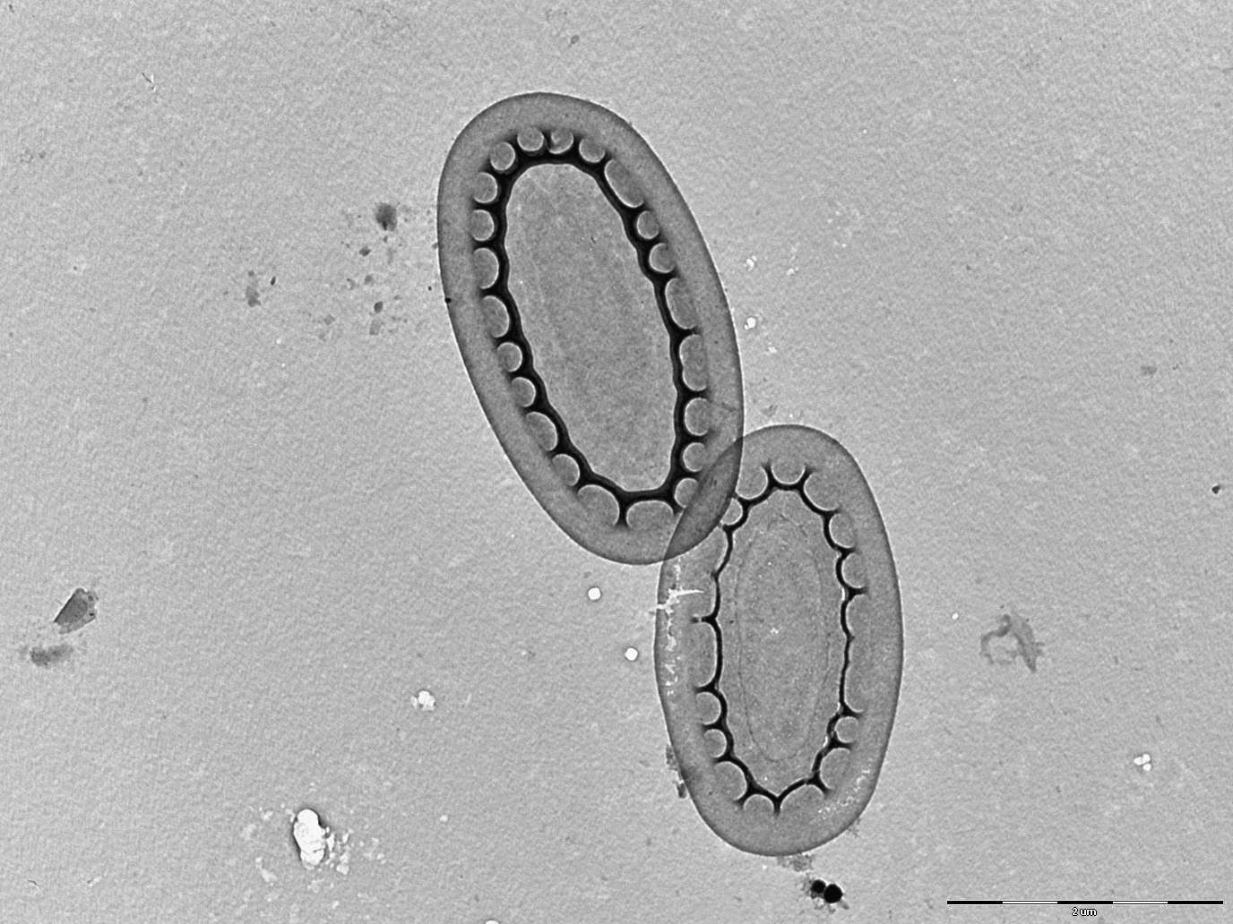
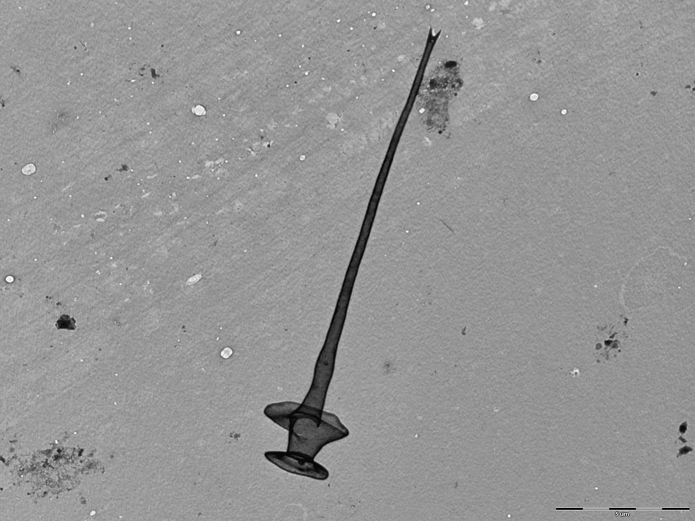
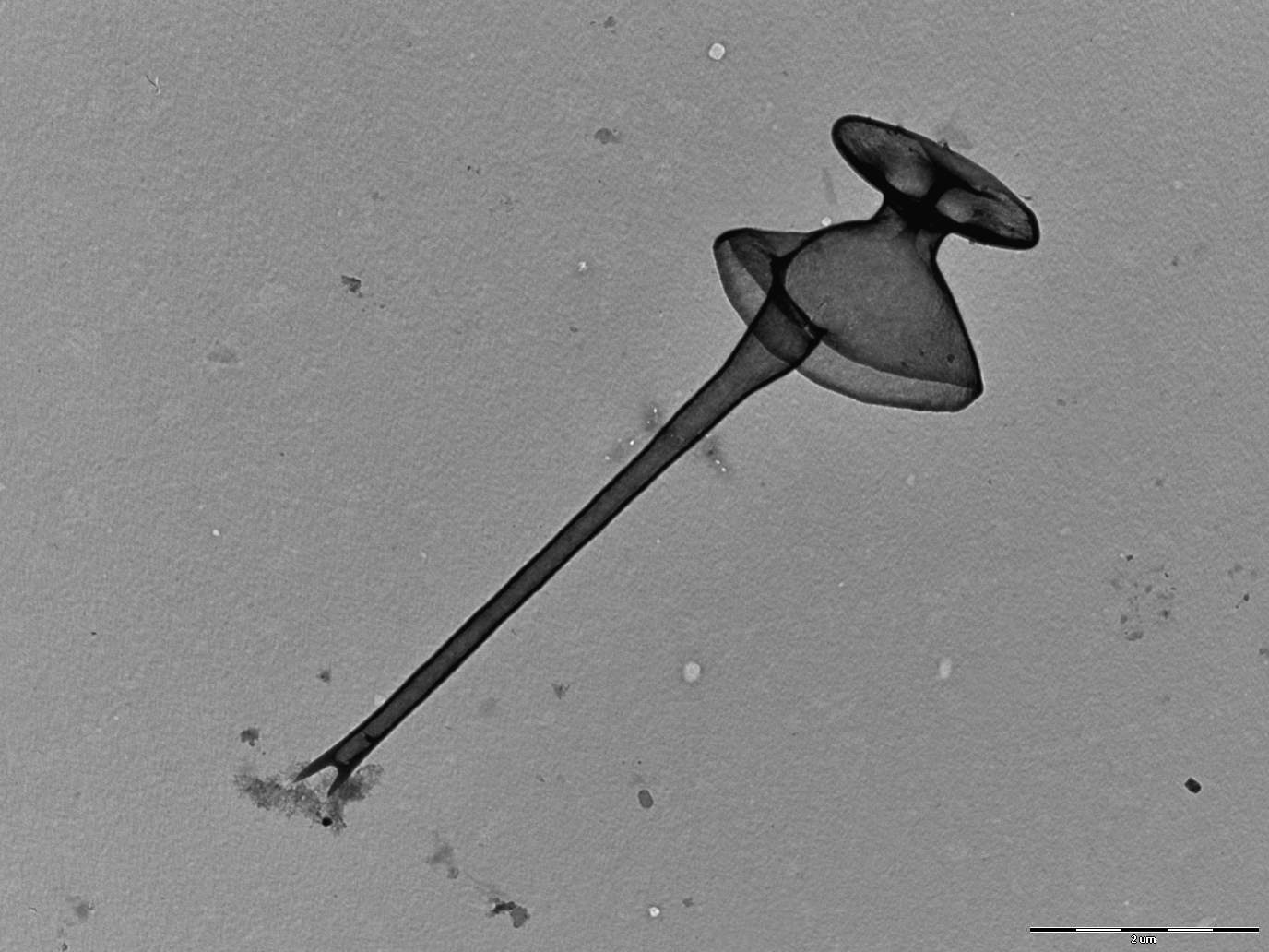
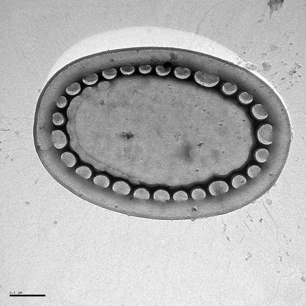
Description: Harris, K. & Bradley, D.E. (1958) Some unusual Chrysophyceae studied in the electron microscope. Journal of General Microbiology 18: 71–83.
Basionym: Korshikov, A.A. (1942) On some new or little known flagellates. Archiv für Protistenkunde 95: 22–44.
Autecology: pH indifferent to acidiphilic, temperature tolerant.
Distribution: cosmopolitan, widely distributed.
Image gallery
List of records
| Locality | Sampling date | pH | Conductivity (μS/cm) | Temperature (°C) | Coordinates | References |
|---|---|---|---|---|---|---|
| Lake Jaala | 2013 | 7.5 | 116 | 14.0 | 59.260322, 27.588356 | CERTNEROVA & SKALOUD (2020) |
| Lake Martiska | 2013 | 7.8 | 127 | 18.0 | 59.263996, 27.570443 | CERTNEROVA & SKALOUD (2020) |
| Kaisma jarv | 2013 | 7.9 | 268 | 20.0 | 58.692952, 24.689511 | CERTNEROVA & SKALOUD (2020) |
| Lake Karula jarv | 2013 | 6.9 | 458 | 15.0 | 58.398583, 25.59201 | CERTNEROVA & SKALOUD (2020) |
| Lake Auksi | 2013 | 7.2 | 483 | 16.0 | 58.462449, 25.59201 | CERTNEROVA & SKALOUD (2020) |
| lake Vaikejarv | 2013 | 6.5 | 71 | 16.0 | 58.490949, 25.755477 | CERTNEROVA & SKALOUD (2020) |
| Lake Vortsjarv (Estonia) | 2013 | 8.2 | 344 | 12.0 | 58.406375, 26.051744 | CERTNEROVA & SKALOUD (2020) |
| Amberger See | 2012 | 5.9 | 16 | 6.3 | 47.226, 10.8853 | PICHRTOVÁ et al. (2013) |
| Piburger See | 2012 | 7.5 | 71 | 8.3 | 47.1952, 10.8861 | PICHRTOVÁ et al. (2013) |
| Lottensee | 2012 | 4.9 | 47.325356, 11.129751 | PICHRTOVÁ et al. (2013) |
Distribution map
Five lakes in Kab-hegyi
Locality:
Five lakes in Kab-hegyi
Coordinates:
47, 17.6
Vltavský luh
Locality:
Vltavský luh
Coordinates:
48.82893, 13.937779
canal of Sutka river
Locality:
canal of Sutka river
Coordinates:
58.049256, 38.251608
Ängersfjärden
Locality:
Ängersfjärden
Coordinates:
63.593464, 19.836539
ephemeral pool
Locality:
ephemeral pool
Coordinates:
58.064468, 38.243574
Lake Rahumeri
Locality:
Lake Rahumeri
Coordinates:
58.18243, 25.052464
near Vanajarve
Locality:
near Vanajarve
Coordinates:
58.016358, 24.70521
Lake Saarde paisjarv
Locality:
Lake Saarde paisjarv
Coordinates:
58.143496, 24.970324
Ahja River
Locality:
Ahja River
Coordinates:
58.26853, 27.132563
pond Ahijarv
Locality:
pond Ahijarv
Coordinates:
58.306502, 27.182326
Lake Jaala
Locality:
Lake Jaala
Coordinates:
59.260322, 27.588356
Lake Martiska
Locality:
Lake Martiska
Coordinates:
59.263996, 27.570443
Kaisma jarv
Locality:
Kaisma jarv
Coordinates:
58.692952, 24.689511
Lake Karula jarv
Locality:
Lake Karula jarv
Coordinates:
58.398583, 25.59201
Lake Auksi
Locality:
Lake Auksi
Coordinates:
58.462449, 25.59201
lake Vaikejarv
Locality:
lake Vaikejarv
Coordinates:
58.490949, 25.755477
Lake Vortsjarv (Estonia)
Locality:
Lake Vortsjarv (Estonia)
Coordinates:
58.406375, 26.051744
Amberger See
Locality:
Amberger See
Coordinates:
47.226, 10.8853
Piburger See
Locality:
Piburger See
Coordinates:
47.1952, 10.8861
Lottensee
Locality:
Lottensee
Coordinates:
47.325356, 11.129751
Seefelder See (Wildsee)
Locality:
Seefelder See (Wildsee)
Coordinates:
47.3224, 11.192
Möserer See
Locality:
Möserer See
Coordinates:
47.3144, 11.1442
Baggersee Rossau
Locality:
Baggersee Rossau
Coordinates:
47.2653, 11.4458
Seerosenweiher
Locality:
Seerosenweiher
Coordinates:
47.243, 11.419
Brennersee
Locality:
Brennersee
Coordinates:
47.0171, 11.5037
Reintaler See
Locality:
Reintaler See
Coordinates:
47.4586, 11.8904
Buchsee
Locality:
Buchsee
Coordinates:
47.455603, 11.885319
Walchsee
Locality:
Walchsee
Coordinates:
47.651, 12.3252
Krummsee
Locality:
Krummsee
Coordinates:
47.456636, 11.883465
Schwarzsee
Locality:
Schwarzsee
Coordinates:
47.456155, 12.366958
Gieringer Weiher
Locality:
Gieringer Weiher
Coordinates:
47.4707, 12.3626
Längsee
Locality:
Längsee
Coordinates:
47.600492, 12.154999
pool near Pfrilsee
Locality:
pool near Pfrilsee
Coordinates:
47.597598, 12.151179
Pfrillsee
Locality:
Pfrillsee
Coordinates:
47.594791, 12.149076
Egelsee
Locality:
Egelsee
Coordinates:
47.613107, 12.170277
brackish water of Pojo Bay
Locality:
brackish water of Pojo Bay
Coordinates:
60.041875, 23.493462
Sysilampi
Locality:
Sysilampi
Coordinates:
63.27793, 24.672883
Valkeisenjärvi
Locality:
Valkeisenjärvi
Coordinates:
63.231095, 24.606578
Ladozskoye ozero, lake
Locality:
Ladozskoye ozero, lake
Coordinates:
60.802064, 31.513367
Konnevesi
Locality:
Konnevesi
Coordinates:
62.600846, 26.547575
Syamozero, Karelia
Locality:
Syamozero, Karelia
Coordinates:
61.962844, 33.083839
Urosozero, Karelia
Locality:
Urosozero, Karelia
Coordinates:
63.440993, 34.253883
Konchezero, Karelia
Locality:
Konchezero, Karelia
Coordinates:
62.138238, 33.978538
Galyezero lake, Karelia (approximate coordinates)
Locality:
Galyezero lake, Karelia (approximate coordinates)
Coordinates:
62.124942, 33.858312
Nikolassee
Locality:
Nikolassee
Coordinates:
52.424146, 13.192077
Stechsee
Locality:
Stechsee
Coordinates:
47.786634, 11.301842
Schluchsee
Locality:
Schluchsee
Coordinates:
47.817535, 8.151112
Windgfällweiher
Locality:
Windgfällweiher
Coordinates:
47.851816, 8.12597
Nonnenmattweiher
Locality:
Nonnenmattweiher
Coordinates:
47.794735, 7.798569
Feldsee
Locality:
Feldsee
Coordinates:
47.87105, 8.032036
Moorweiher in Bärnau
Locality:
Moorweiher in Bärnau
Coordinates:
49.81085, 12.433949
Moorweiher in Bärnau
Locality:
Moorweiher in Bärnau
Coordinates:
49.81085, 12.433949
Gaisweiher
Locality:
Gaisweiher
Coordinates:
49.74305, 12.341101
Silbersee
Locality:
Silbersee
Coordinates:
49.412481, 12.596984
Eixendorfer Speicher
Locality:
Eixendorfer Speicher
Coordinates:
49.339441, 12.445965
Perlsee
Locality:
Perlsee
Coordinates:
49.392849, 12.699208
Kis-Jusztus swamp, temporary
Locality:
Kis-Jusztus swamp, temporary
Coordinates:
47.57502, 21.022854
Kis-Balaton reservoir
Locality:
Kis-Balaton reservoir
Coordinates:
46.628221, 17.151604
Rókás, backwater of the Danube
Locality:
Rókás, backwater of the Danube
Coordinates:
47.094319, 18.922648
small groundwater pond before entering Szigetcsép, at the road coming from Tököl
Locality:
small groundwater pond before entering Szigetcsép, at the road coming from Tököl
Coordinates:
47.272561, 18.975512
small oligotrophic lake at Abisko
Locality:
small oligotrophic lake at Abisko
Coordinates:
68.345083, 19.114267
small oligotrophic lake at Abisko
Locality:
small oligotrophic lake at Abisko
Coordinates:
68.348233, 19.03925
small oligotrophic lake at Abisko
Locality:
small oligotrophic lake at Abisko
Coordinates:
68.349433, 19.023483
small oligotrophic lake at Abisko
Locality:
small oligotrophic lake at Abisko
Coordinates:
68.347048, 18.911247
Kuzty Lake
Locality:
Kuzty Lake
Coordinates:
67.6, 65.65
alluvial pools, Lužnice River
Locality:
alluvial pools, Lužnice River
Coordinates:
48.835123, 14.927174
Égeres, small temporary forest pond, Pilis/Visegrád Mountains, Király-valley (approx.)
Locality:
Égeres, small temporary forest pond, Pilis/Visegrád Mountains, Király-valley (approx.)
Coordinates:
47.74, 18.92
oligotrophic pool near lake Vassijaure
Locality:
oligotrophic pool near lake Vassijaure
Coordinates:
68.441939, 18.265586
Bastemose, Bornholm
Locality:
Bastemose, Bornholm
Coordinates:
55.126367, 14.942558
Kohullet
Locality:
Kohullet
Coordinates:
55.123005, 14.891299
Store Grydesø
Locality:
Store Grydesø
Coordinates:
55.083821, 15.096495
Vallensgaard mose
Locality:
Vallensgaard mose
Coordinates:
55.137959, 14.907705
Ølene
Locality:
Ølene
Coordinates:
55.100987, 15.014012
Kohullet
Locality:
Kohullet
Coordinates:
55.12303, 14.891188
Borresø, small lake at Lilleborg castle
Locality:
Borresø, small lake at Lilleborg castle
Coordinates:
55.118, 14.897633
various localities within 30 miles from Edinburgh, Scotland
Locality:
various localities within 30 miles from Edinburgh, Scotland
Coordinates:
55.953237, -3.188782
János Pond, Visegrád mountains
Locality:
János Pond, Visegrád mountains
Coordinates:
47.71364, 19.01981
small pond in mountain grassland, Visegrád mountains
Locality:
small pond in mountain grassland, Visegrád mountains
Coordinates:
47.72682, 19.01658
small bog pond in the Visegrád mountains
Locality:
small bog pond in the Visegrád mountains
Coordinates:
47.713521, 19.040333
small bog pond in the middle of an alder forest, Visegrád mountains
Locality:
small bog pond in the middle of an alder forest, Visegrád mountains
Coordinates:
47.707497, 19.040247
Kis-Balaton reservoir
Locality:
Kis-Balaton reservoir
Coordinates:
46.635294, 17.146111
undefined localities (approx. coord.)
Locality:
undefined localities (approx. coord.)
Coordinates:
61.543641, 25.422363
Store Grydesø
Locality:
Store Grydesø
Coordinates:
55.083821, 15.096495
Nydam
Locality:
Nydam
Coordinates:
55.220236, 14.763111
Hammersø
Locality:
Hammersø
Coordinates:
55.282879, 14.765267
Klemensker, pond
Locality:
Klemensker, pond
Coordinates:
55.181906, 14.818053
Södra Bergundasjön
Locality:
Södra Bergundasjön
Coordinates:
56.850192, 14.782519
Växjösjön - eutrophic polluted lake
Locality:
Växjösjön - eutrophic polluted lake
Coordinates:
56.867554, 14.809198
Trummen - eutrophic-polluted lake
Locality:
Trummen - eutrophic-polluted lake
Coordinates:
56.851225, 14.781218
Lammen - oligotrophic humic lake
Locality:
Lammen - oligotrophic humic lake
Coordinates:
57.164546, 14.602346
Langen - oligotrophic humic lake
Locality:
Langen - oligotrophic humic lake
Coordinates:
57.150396, 14.657078
Straken - oligotrophic humic lake
Locality:
Straken - oligotrophic humic lake
Coordinates:
57.09523, 14.59631
Gardsjön - oligotrophic humic lake
Locality:
Gardsjön - oligotrophic humic lake
Coordinates:
57.154306, 14.631672
Helgasjön - oligotrophic clear water lake
Locality:
Helgasjön - oligotrophic clear water lake
Coordinates:
56.962947, 14.728317
Fiolen - oligotrophic clear water lake
Locality:
Fiolen - oligotrophic clear water lake
Coordinates:
57.084038, 14.526443
near Reading - acid ponds without Sphagnum
Locality:
near Reading - acid ponds without Sphagnum
Coordinates:
51.455504, -0.9902
Malvaniemi, lake Puulavesi
Locality:
Malvaniemi, lake Puulavesi
Coordinates:
61.729005, 26.817598
Pääskynniemi II, shore of lake Puulavesi
Locality:
Pääskynniemi II, shore of lake Puulavesi
Coordinates:
61.722337, 26.897936
Sawmill, lake Kotkatvesi
Locality:
Sawmill, lake Kotkatvesi
Coordinates:
61.672934, 26.849699
Rehniöniemi, lake Ryökäsvesi
Locality:
Rehniöniemi, lake Ryökäsvesi
Coordinates:
61.627042, 26.845922
Etuniemi - beach beside Lake Liekune
Locality:
Etuniemi - beach beside Lake Liekune
Coordinates:
61.669839, 26.744442
lake Þingvallavatn and adjacent ponds
Locality:
lake Þingvallavatn and adjacent ponds
Coordinates:
64.197113, -21.137123
Tystrup Sø
Locality:
Tystrup Sø
Coordinates:
55.369356, 11.570606
small forest pond at biological station Husö, Åland, probably temporary
Locality:
small forest pond at biological station Husö, Åland, probably temporary
Coordinates:
60.278866, 19.83034
Kvarntrask, Åland
Locality:
Kvarntrask, Åland
Coordinates:
60.345978, 19.971743
Brantsböle Träsk, Åland
Locality:
Brantsböle Träsk, Åland
Coordinates:
60.26911, 19.925201
Kotjärnan, Åland
Locality:
Kotjärnan, Åland
Coordinates:
60.328902, 19.847903
Bergö träsk, Åland
Locality:
Bergö träsk, Åland
Coordinates:
60.300827, 19.833105
Långträsk, Åland
Locality:
Långträsk, Åland
Coordinates:
60.169183, 19.788237
St. Jansberg
Locality:
St. Jansberg
Coordinates:
51.737813, 5.922781
St. Jansberg
Locality:
St. Jansberg
Coordinates:
51.737813, 5.922781
Geuldert
Locality:
Geuldert
Coordinates:
51.737651, 5.929827
Erpewaai IV
Locality:
Erpewaai IV
Coordinates:
51.761054, 5.827293
Erpewaai III
Locality:
Erpewaai III
Coordinates:
51.761054, 5.827293
Erpewaai II
Locality:
Erpewaai II
Coordinates:
51.761054, 5.827293
pool near pond-Loampit near Udenhout
Locality:
pool near pond-Loampit near Udenhout
Coordinates:
51.608903, 5.182114
Loampit near Udenhout, pond
Locality:
Loampit near Udenhout, pond
Coordinates:
51.608903, 5.182114
ditch near Schijndel
Locality:
ditch near Schijndel
Coordinates:
51.620948, 5.433683
ditch I at Vortum Millum
Locality:
ditch I at Vortum Millum
Coordinates:
51.623452, 5.977764
Broekse Wielen IV., pond near the river Meuse
Locality:
Broekse Wielen IV., pond near the river Meuse
Coordinates:
51.728889, 5.763788
Broekse Wielen II., pond near the river Meuse
Locality:
Broekse Wielen II., pond near the river Meuse
Coordinates:
51.728889, 5.763788
moorland pool, Rolvennen I.
Locality:
moorland pool, Rolvennen I.
Coordinates:
51.171244, 6.107883
small ditch in Nijmegen
Locality:
small ditch in Nijmegen
Coordinates:
51.831322, 5.812454
moorland pools Hatertse and Overasseltse Vennen, Uiversnest
Locality:
moorland pools Hatertse and Overasseltse Vennen, Uiversnest
Coordinates:
51.78425, 5.805845
pond in Groenlanden
Locality:
pond in Groenlanden
Coordinates:
51.869946, 5.916524
pond E of the Oude Waal
Locality:
pond E of the Oude Waal
Coordinates:
51.855052, 5.897727
fishpond near Oude Waal
Locality:
fishpond near Oude Waal
Coordinates:
51.853912, 5.888844
Immerlooplas
Locality:
Immerlooplas
Coordinates:
51.955189, 5.91485
pond F of the Oude Waal, pH neutral to slightly alkaline
Locality:
pond F of the Oude Waal, pH neutral to slightly alkaline
Coordinates:
51.855847, 5.900259
pond D of the Oude Waal, pH neutral to slightly alkaline
Locality:
pond D of the Oude Waal, pH neutral to slightly alkaline
Coordinates:
51.853091, 5.896783
Szeremlei holtág, a sluice on backwater of the R. Danube at Baja city
Locality:
Szeremlei holtág, a sluice on backwater of the R. Danube at Baja city
Coordinates:
46.168874, 18.941966
peat bog Tau cu botile near Salicea, spring
Locality:
peat bog Tau cu botile near Salicea, spring
Coordinates:
46.678387, 23.527885
small eutrophic habitat near Salicea, under ice
Locality:
small eutrophic habitat near Salicea, under ice
Coordinates:
46.678387, 23.527885
eutrophic bog, Mestecănişul de la Reci
Locality:
eutrophic bog, Mestecănişul de la Reci
Coordinates:
45.822582, 25.926525
eutrophic bog, Mestecănişul de la Reci
Locality:
eutrophic bog, Mestecănişul de la Reci
Coordinates:
45.822582, 25.926525
Baláta-tó, bog lake complex, shallow waters among sedge humocks and floating peat islands, after ice melting
Locality:
Baláta-tó, bog lake complex, shallow waters among sedge humocks and floating peat islands, after ice melting
Coordinates:
46.311011, 17.207508
Hortobágy, small fishpond
Locality:
Hortobágy, small fishpond
Coordinates:
47.609404, 21.065254
Hortobágy, large fishpond
Locality:
Hortobágy, large fishpond
Coordinates:
47.609404, 21.065254
Debrecen-Hortobágy road (no. 33) 96th km section, reservoir
Locality:
Debrecen-Hortobágy road (no. 33) 96th km section, reservoir
Coordinates:
47.559905, 21.453209
Brehynsky pond
Locality:
Brehynsky pond
Coordinates:
50.579167, 14.703611
Vorkuta tundra, pond Vorgashor
Locality:
Vorkuta tundra, pond Vorgashor
Coordinates:
67.583333, 63.783333
Vorkuta tundra, pond, Vorkuta City
Locality:
Vorkuta tundra, pond, Vorkuta City
Coordinates:
67.5, 64.666667
Vorkuta tundra, pond Mulda
Locality:
Vorkuta tundra, pond Mulda
Coordinates:
67.383333, 63.75
Vash.-Kharbey, small pond
Locality:
Vash.-Kharbey, small pond
Coordinates:
67.8868, 62.196694
Vash.-Kharbey, small pond
Locality:
Vash.-Kharbey, small pond
Coordinates:
67.908328, 62.190278
Vash.-Kharbey, small pond
Locality:
Vash.-Kharbey, small pond
Coordinates:
67.952311, 62.001283
Kharbey, small pond
Locality:
Kharbey, small pond
Coordinates:
67.540614, 62.979672
Vashutkini, Vaniukti Lake
Locality:
Vashutkini, Vaniukti Lake
Coordinates:
67.969397, 61.533269
Vashutkini, small pond
Locality:
Vashutkini, small pond
Coordinates:
67.962981, 61.529667
Province of Gelderland, Molenwiel
Locality:
Province of Gelderland, Molenwiel
Coordinates:
51.770605, 5.754626
Coimbra
Locality:
Coimbra
Coordinates:
40.212441, -8.4375
Mondego Basin, Raiva
Locality:
Mondego Basin, Raiva
Coordinates:
41.274694, -7.510169
Lake Ladoga, Petrokrepost Bay, station C
Locality:
Lake Ladoga, Petrokrepost Bay, station C
Coordinates:
60.114145, 31.333008
Magleås Conference Centre, Høsterkøb, North Zealand
Locality:
Magleås Conference Centre, Høsterkøb, North Zealand
Coordinates:
55.855363, 12.468255
Madriz puddle
Locality:
Madriz puddle
Coordinates:
40.179431, -8.688576
a pool above the turbid pond at the road from Hřensko to Mezní L
Locality:
a pool above the turbid pond at the road from Hřensko to Mezní L
Coordinates:
50.875, 14.303056
a pond in a forest on the Suchá Bělá Stream
Locality:
a pond in a forest on the Suchá Bělá Stream
Coordinates:
50.881918, 14.260769
Prokopova pool
Locality:
Prokopova pool
Coordinates:
48.833894, 14.927651
T2 pool
Locality:
T2 pool
Coordinates:
48.835123, 14.927174
T2 pool
Locality:
T2 pool
Coordinates:
48.835123, 14.927174
T2 pool
Locality:
T2 pool
Coordinates:
48.835123, 14.927174
T2 pool
Locality:
T2 pool
Coordinates:
48.835123, 14.927174
T2 pool
Locality:
T2 pool
Coordinates:
48.835123, 14.927174
T2 pool
Locality:
T2 pool
Coordinates:
48.835123, 14.927174
Vezak pond
Locality:
Vezak pond
Coordinates:
50.515118, 15.188427
pond in Zizkuv Dvorec
Locality:
pond in Zizkuv Dvorec
Coordinates:
48.892381, 14.607171
Vezak pond
Locality:
Vezak pond
Coordinates:
50.514982, 15.188942
Vidlak pond
Locality:
Vidlak pond
Coordinates:
50.521759, 15.210732
Rokytnicky pond
Locality:
Rokytnicky pond
Coordinates:
50.530558, 15.221515
peat bog Vidlak
Locality:
peat bog Vidlak
Coordinates:
50.524524, 15.217851
Reka pond
Locality:
Reka pond
Coordinates:
49.671738, 15.848808
pool in Ranska jezirka Reserve
Locality:
pool in Ranska jezirka Reserve
Coordinates:
49.654745, 15.813156
Ransky pond
Locality:
Ransky pond
Coordinates:
49.683124, 15.83293
Sabrava brook
Locality:
Sabrava brook
Coordinates:
49.556966, 15.915574
Velke Darko pond
Locality:
Velke Darko pond
Coordinates:
49.632896, 15.902195
peat bogs near Meyrbach, Lipno
Locality:
peat bogs near Meyrbach, Lipno
Coordinates: