List of species
-
Mallomonas
-
a
- Mallomonas acaroides
- Mallomonas acaroides var. inermis
- Mallomonas actinoloma
- Mallomonas actinoloma var. maramuresensis
- Mallomonas actinoloma var. nadiensis
- Mallomonas adamas
- Mallomonas akrokomos
- Mallomonas alata
- Mallomonas allorgei
- Mallomonas alphaphora
- Mallomonas alpina
- Mallomonas alveolata
- Mallomonas annulata
- Mallomonas areolata
-
b - c
- Mallomonas balonovii
- Mallomonas bangladeshica
- Mallomonas calceolus
- Mallomonas canina
- Mallomonas caudata
- Mallomonas clavus
- Mallomonas conspersa
- Mallomonas corcontica
- Mallomonas corymbosa
- Mallomonas costata
- Mallomonas crassisquama
- Mallomonas crassisquama var. papillosa
- Mallomonas cratis
- Mallomonas cristata
- Mallomonas cucullata
- Mallomonas cyathellata
- d - g
- h - k
-
l - m
- Mallomonas labyrinthina
- Mallomonas leboimei
- Mallomonas lelymene
- Mallomonas lychenensis
- Mallomonas lychenensis f. symposiaca
- Mallomonas maculata
- Mallomonas mangofera
- Mallomonas mangofera var. gracilis
- Mallomonas mangofera var. reticulata
- Mallomonas matvienkoae
- Mallomonas multisetigera
- Mallomonas multiunca
- Mallomonas munda
- o - ph
-
pi - pu
- Mallomonas pillula
- Mallomonas pillula f. exannulata
- Mallomonas pillula f. latimarginalis
- Mallomonas pillula f. valdiviana
- Mallomonas portae-ferreae
- Mallomonas prora
- Mallomonas pseudocoronata
- Mallomonas pseudocratis
- Mallomonas pugio
- Mallomonas pumilio
- Mallomonas pumilio var. dispersa
- Mallomonas punctifera
- Mallomonas punctifera var. brasiliensis
- r - s
- t - z
-
a
-
Synura
- a - g
- h - m
- n - u
- Neotessella
-
Paraphysomonas
- a - ci
- co - h
- i - q
- r - v
-
Lepidochromonas
- c - i
-
m - u
- Lepidochromonas manubriata
- Lepidochromonas morchella
- Lepidochromonas poteriophora
- Lepidochromonas quadrispina
- Lepidochromonas runcinifera
- Lepidochromonas sigillifera
- Lepidochromonas stelligera
- Lepidochromonas stephanolepis
- Lepidochromonas subquadrangularis
- Lepidochromonas subrotacea
- Lepidochromonas takahashii
- Lepidochromonas undulata
-
Spiniferomonas
- a - c
- m - t
- Chrysosphaerella
- Polylepidomonas
Search
General information
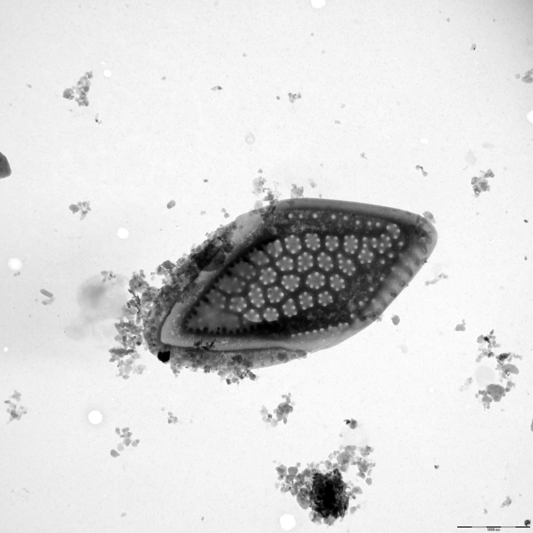
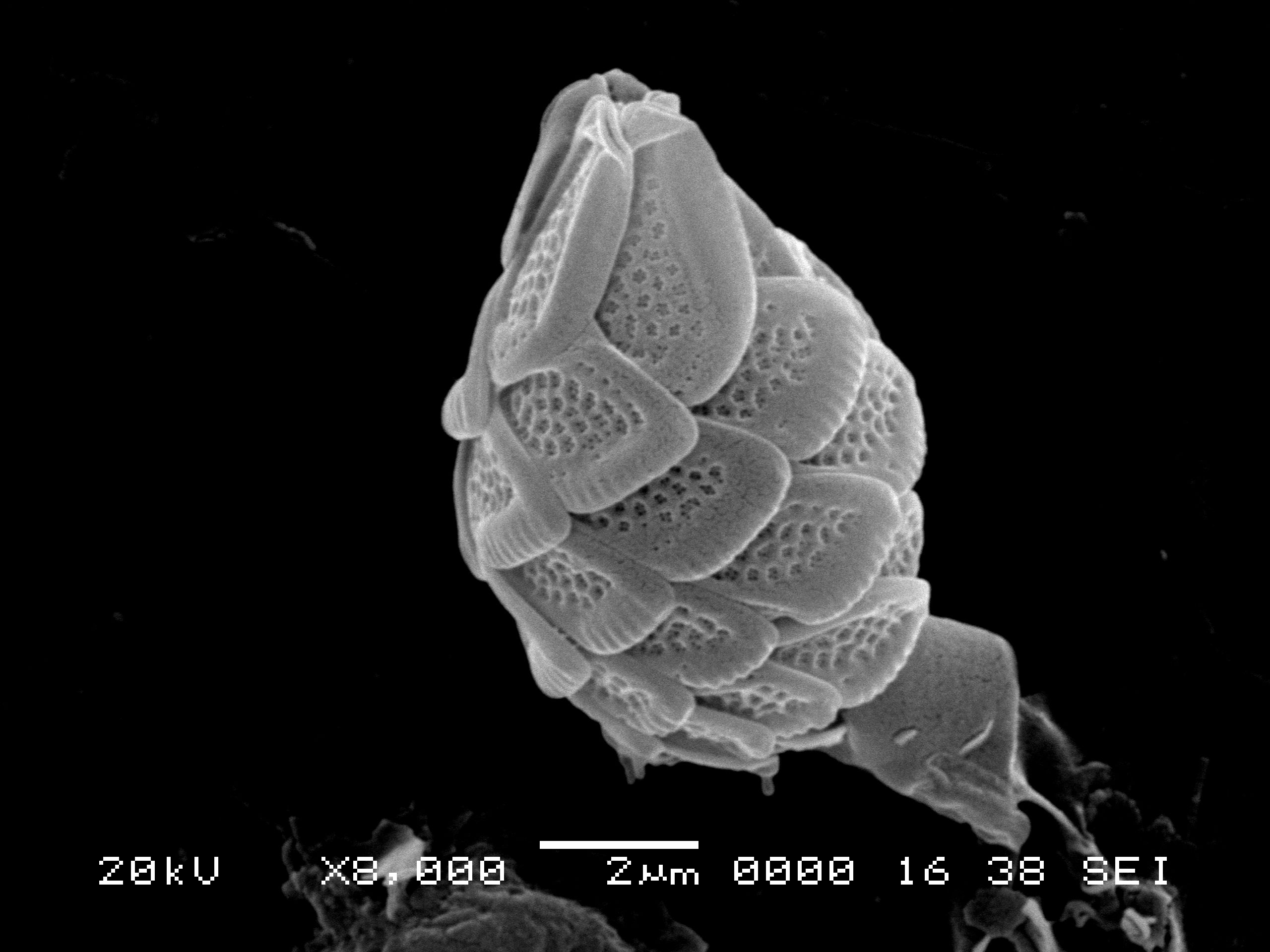
Description: Asmund, B., Cronberg, G. & Dürrschmidt, M. (1982): Revision of the Mallomonas pumilio group (Chrysophyceae). - Nordic Journal of Botany 2: 383-395.
Autecology: mesotrophic to moderately eutrophic.
Distribution: widely distributed.
Image gallery

List of records
| Locality | Sampling date | pH | Conductivity (μS/cm) | Temperature (°C) | Coordinates | References |
|---|---|---|---|---|---|---|
| léon-Soustons region, small lake between Étang du Houa and Étang de Léon | 2010 | 7.2 | 123 | 17.5 | 43.894222, -1.303278 | NEMCOVA et al. (2012) |
| Bousquet region, Marais du Cla, small pool | 2010 | 5.6 | 126 | 23.9 | 44.515806, -0.607528 | NEMCOVA et al. (2012) |
| Cazaux-Biscarrosse region,Grand Étang de Biscarrosse | 2010 | 7.4 | 239 | 44.387111, -1.188583 | NEMCOVA et al. (2012) | |
| Cazaux-Biscarrosse region, small pool near eastern bank of Étang de Cazaux | 2010 | 7.6 | 241 | 9.1 | 44.469303, -1.126964 | NEMCOVA et al. (2012) |
| Lacanau region, Étang de Lacanau | 2010 | 6.8 | 193 | 19.4 | 44.971583, -1.098028 | NEMCOVA et al. (2012) |
| 1981 | 5.9 | 183 | 6.3 | DÜRRSCHMIDT (1984) | ||
| 1981 | 6.1 | 190 | 4.0 | DÜRRSCHMIDT (1984) | ||
| Rohrpfuhl | 52.597678, 13.161263 | GUTOWSKI (1997) | ||||
| Nikolassee | 52.424198, 13.192077 | GUTOWSKI (1997) | ||||
| Kuhlake, ditch | 52.572959, 13.171098 | GUTOWSKI (1997) |
Distribution map
Five lakes in Kab-hegyi
Locality:
Five lakes in Kab-hegyi
Coordinates:
47, 17.6
Lužnice oxbow lake, Suchdol
Locality:
Lužnice oxbow lake, Suchdol
Coordinates:
48.9088967, 14.8907903
Lake Rahumeri
Locality:
Lake Rahumeri
Coordinates:
58.18243, 25.052464
near Vanajarve
Locality:
near Vanajarve
Coordinates:
58.016358, 24.70521
Lake Saarde paisjarv
Locality:
Lake Saarde paisjarv
Coordinates:
58.143496, 24.970324
Ahja River
Locality:
Ahja River
Coordinates:
58.26853, 27.132563
pond Ahijarv
Locality:
pond Ahijarv
Coordinates:
58.306502, 27.182326
Emajoe-Suursoo sookaitseala/maastikukaitseala
Locality:
Emajoe-Suursoo sookaitseala/maastikukaitseala
Coordinates:
58.335374, 27.263844
Lake Jaala
Locality:
Lake Jaala
Coordinates:
59.260322, 27.588356
Kaisma jarv
Locality:
Kaisma jarv
Coordinates:
58.692952, 24.689511
River Emajogi
Locality:
River Emajogi
Coordinates:
58.396362, 26.310943
Locality:
Coordinates:
58.396362, 26.310943
Lake Karula jarv
Locality:
Lake Karula jarv
Coordinates:
58.398583, 25.59201
fishpond near Mauschlhütte
Locality:
fishpond near Mauschlhütte
Coordinates:
47.275415, 10.808101
Seefelder See (Wildsee)
Locality:
Seefelder See (Wildsee)
Coordinates:
47.3224, 11.192
Buchsee
Locality:
Buchsee
Coordinates:
47.455603, 11.885319
Schwarzsee
Locality:
Schwarzsee
Coordinates:
47.456155, 12.366958
Gieringer Weiher
Locality:
Gieringer Weiher
Coordinates:
47.4707, 12.3626
Bufernoe lake, Vorkutinskaya tundra, Russia
Locality:
Bufernoe lake, Vorkutinskaya tundra, Russia
Coordinates:
67.519926, 64.35585
Léon-Soustons region, Étang de Léon
Locality:
Léon-Soustons region, Étang de Léon
Coordinates:
43.894556, -1.307472
léon-Soustons region, small lake between Étang du Houa and Étang de Léon
Locality:
léon-Soustons region, small lake between Étang du Houa and Étang de Léon
Coordinates:
43.894222, -1.303278
Bousquet region, Marais du Cla, small pool
Locality:
Bousquet region, Marais du Cla, small pool
Coordinates:
44.515806, -0.607528
Cazaux-Biscarrosse region,Grand Étang de Biscarrosse
Locality:
Cazaux-Biscarrosse region,Grand Étang de Biscarrosse
Coordinates:
44.387111, -1.188583
Cazaux-Biscarrosse region, small pool near eastern bank of Étang de Cazaux
Locality:
Cazaux-Biscarrosse region, small pool near eastern bank of Étang de Cazaux
Coordinates:
44.469303, -1.126964
Lacanau region, Étang de Lacanau
Locality:
Lacanau region, Étang de Lacanau
Coordinates:
44.971583, -1.098028
Rohrpfuhl
Locality:
Rohrpfuhl
Coordinates:
52.597678, 13.161263
Nikolassee
Locality:
Nikolassee
Coordinates:
52.424198, 13.192077
Kuhlake, ditch
Locality:
Kuhlake, ditch
Coordinates:
52.572959, 13.171098
Kuhlake, pond
Locality:
Kuhlake, pond
Coordinates:
52.564404, 13.194144
ditch between Rathjensdorf and Kossau
Locality:
ditch between Rathjensdorf and Kossau
Coordinates:
54.194634, 10.440345
meadow pond north of Trammer See
Locality:
meadow pond north of Trammer See
Coordinates:
54.181501, 10.42074
Lebrader Teich
Locality:
Lebrader Teich
Coordinates:
54.220536, 10.428421
Grosser Binnensee
Locality:
Grosser Binnensee
Coordinates:
54.325434, 10.622821
Plusssee inlet, west
Locality:
Plusssee inlet, west
Coordinates:
54.182267, 10.440969
Schmarksee
Locality:
Schmarksee
Coordinates:
54.183359, 10.487001
Nikolassee
Locality:
Nikolassee
Coordinates:
52.424146, 13.192077
Mathislesweiher
Locality:
Mathislesweiher
Coordinates:
47.884953, 8.084214
Eixendorfer Speicher
Locality:
Eixendorfer Speicher
Coordinates:
49.339441, 12.445965
swamp in Vindornyaszölös
Locality:
swamp in Vindornyaszölös
Coordinates:
46.905832, 17.167211
Kis-Jusztus swamp, temporary
Locality:
Kis-Jusztus swamp, temporary
Coordinates:
47.57502, 21.022854
Kis-Balaton reservoir
Locality:
Kis-Balaton reservoir
Coordinates:
46.628221, 17.151604
small pond, 2.5 km south from Sármellék, at the road towards Balatonmagyaród
Locality:
small pond, 2.5 km south from Sármellék, at the road towards Balatonmagyaród
Coordinates:
46.682892, 17.169714
Rókás, backwater of the Danube
Locality:
Rókás, backwater of the Danube
Coordinates:
47.094319, 18.922648
small oligotrophic lake at Abisko
Locality:
small oligotrophic lake at Abisko
Coordinates:
68.347048, 18.911247
Usvaty lake
Locality:
Usvaty lake
Coordinates:
67.733333, 65.983333
Usvaty lake
Locality:
Usvaty lake
Coordinates:
67.733333, 65.983333
Sidiyambtosio Lake
Locality:
Sidiyambtosio Lake
Coordinates:
68.116667, 65.5
Ochetivis River
Locality:
Ochetivis River
Coordinates:
68.103889, 65.844444
alluvial pools, Lužnice River
Locality:
alluvial pools, Lužnice River
Coordinates:
48.835123, 14.927174
alluvial pools, Lužnice River, Mallomonas in years 2000-2003
Locality:
alluvial pools, Lužnice River, Mallomonas in years 2000-2003
Coordinates:
48.810255, 14.930763
Égeres, small temporary forest pond, Pilis/Visegrád Mountains, Király-valley (approx.)
Locality:
Égeres, small temporary forest pond, Pilis/Visegrád Mountains, Király-valley (approx.)
Coordinates:
47.74, 18.92
lake Pamvotis
Locality:
lake Pamvotis
Coordinates:
39.671785, 20.877056
János Pond, Visegrád mountains
Locality:
János Pond, Visegrád mountains
Coordinates:
47.71364, 19.01981
small bog pond in the Visegrád mountains
Locality:
small bog pond in the Visegrád mountains
Coordinates:
47.713521, 19.040333
small bog pond in the middle of an alder forest, Visegrád mountains
Locality:
small bog pond in the middle of an alder forest, Visegrád mountains
Coordinates:
47.707497, 19.040247
Kis-Balaton reservoir
Locality:
Kis-Balaton reservoir
Coordinates:
46.635294, 17.146111
flooded meadows near Malmö
Locality:
flooded meadows near Malmö
Coordinates:
55.564369, 13.072357
Tystrup Sø
Locality:
Tystrup Sø
Coordinates:
55.369356, 11.570606
Zeller Loch, Fulda
Locality:
Zeller Loch, Fulda
Coordinates:
50.513392, 9.620998
Erpewaai I
Locality:
Erpewaai I
Coordinates:
51.761054, 5.827293
Oisterwijkse Vennen, group of moorland pools, Staalbergsven
Locality:
Oisterwijkse Vennen, group of moorland pools, Staalbergsven
Coordinates:
51.57301, 5.222797
pond F of the Oude Waal, pH neutral to slightly alkaline
Locality:
pond F of the Oude Waal, pH neutral to slightly alkaline
Coordinates:
51.855847, 5.900259
pond D of the Oude Waal, pH neutral to slightly alkaline
Locality:
pond D of the Oude Waal, pH neutral to slightly alkaline
Coordinates:
51.853091, 5.896783
Baláta-tó, bog lake complex, shallow waters among sedge humocks and floating peat islands, after ice melting
Locality:
Baláta-tó, bog lake complex, shallow waters among sedge humocks and floating peat islands, after ice melting
Coordinates:
46.311011, 17.207508
Brehynsky pond
Locality:
Brehynsky pond
Coordinates:
50.579167, 14.703611
Swamp-Northern portion
Locality:
Swamp-Northern portion
Coordinates:
50.580053, 14.667992
Vorkuta tundra, pond Vorgashor
Locality:
Vorkuta tundra, pond Vorgashor
Coordinates:
67.583333, 63.783333
Vorkuta tundra, pond Sovetsky
Locality:
Vorkuta tundra, pond Sovetsky
Coordinates:
67.516667, 64.366667
Vorkuta tundra, pond Mulda
Locality:
Vorkuta tundra, pond Mulda
Coordinates:
67.383333, 63.75
Vash.-Kharbey, small pond
Locality:
Vash.-Kharbey, small pond
Coordinates:
67.908328, 62.190278
Kharbey, small pond
Locality:
Kharbey, small pond
Coordinates:
67.538475, 62.745544
Vashutkini, Vaniukti Lake
Locality:
Vashutkini, Vaniukti Lake
Coordinates:
67.960497, 61.519275
Prokopova pool
Locality:
Prokopova pool
Coordinates:
48.833894, 14.927651
T2 pool
Locality:
T2 pool
Coordinates:
48.835123, 14.927174
T2 pool
Locality:
T2 pool
Coordinates:
48.835123, 14.927174
T2 pool
Locality:
T2 pool
Coordinates:
48.835123, 14.927174
Vezak pond
Locality:
Vezak pond
Coordinates:
50.515118, 15.188427
Rokytnicky pond
Locality:
Rokytnicky pond
Coordinates:
50.530558, 15.221515
pond near Svetnov
Locality:
pond near Svetnov
Coordinates:
49.626888, 15.95254
forest pool near Stare Ransko
Locality:
forest pool near Stare Ransko
Coordinates:
49.673669, 15.832329
Sabrava brook
Locality:
Sabrava brook
Coordinates:
49.556966, 15.915574
Velke Darko pond
Locality:
Velke Darko pond
Coordinates:
49.632896, 15.902195
Hradcansky pond
Locality:
Hradcansky pond
Coordinates:
50.617313, 14.710093
Macha lake
Locality:
Macha lake
Coordinates: